~ Route Overviews ~


~ Grand Teton Trip Reports ~
Live feed may be off if CC is closed, etc
~~~~~~~~~~~~~~~~~~~~~~~


Summer 2026 Notes
TCSAR's 2025 Rescue Report included several climbing missions in GTNP - plenty of 4th class, snow slopes, scrambles, and weather related accidents. Snow was a common problem in the North and South Forks of Garnet Canyon—as always.
JL Climbing Rangers ~ Teton Backcountry Rentals ~
Bridger Teton Avalanche Forecast ~ BTAC 24hr Weather Big Sheet ~ * Lower Saddle Forecast *
~ Saddle's Detailed Hourly Forecast ~ Aurora Forecast ~ Night Sky ~ BackcountryZero
~ TCSAR ~
TCISAR
Just because it was a mild winter doesn't mean May and June can't dump snow up high. At the moment, it's looking like the approach to the Lower Saddle will burn off early, just like last year—maybe mid-June but that's a wild guess. The outlook for the wildfire season is also a wild guess but it's already started in Wyoming.
~~~~~~~~~~~~~~~
Advanced
backcountry camping permits for the peak season (May 1–October 31,
2026) may be available at Recreation.gov. They fill up quickly. The high season is looking busy for campgrounds & hotels too. Unused backcountry slots might become available during the summer due to cancellations. Most permits are set aside for Walk-ins which can be picked up 1 day before your trip begins (assuming the park hasn't run out of space for your destination).
The Teton Park Rd opens between the
Taggart Lake Trailhead
& Signal Mountain Lodge on May 1. There are parking spots at the Taggart Lake trailhead that are set aside for people on overnight off-season backcountry camping
trips. Look for the sign.
Non-peak season (November 1–April 30) winter backcountry camping permits can be obtained at the Visitor Center in Moose. They're free. The visitor center is open.
If you're planning to go climbing in Death Canyon this summer, the Death Canyon Trailhead will be closed for construction. We're not sure if that means the entire dirt road is off limits to hikers and vehicles but that would seem likely, at least past the junction to the White Grass housing area. There may be temporary access for hikers that bypasses construction but that's unknown. Expect multiple construction projects in Grand Teton National Park in 2026, especially in the southern end of the park. Keep this in mind if you plan to use the Moose-Wilson Rd.
The Lower Saddle's weather station data wasn't available to the public last year. That might be an issue this year too. Speaking of weather stations, the latency of valley stations is an issue (hour behind, etc). If you try accessing stations from a Mesowest map, they may not show up unless you add a latency variable to your search string, usually: &within=x where "x" is minutes. We'll update our links before June rolls into town. The problem is on the BTAC/GTNP side for stations like the two Surprise Lake stations and the Lower Saddle one. They push the data out late. Rumors about lost code and upgrades as the cause may be true, or not. The Saddle's station used to update on the web every 15 minutes. The missing map data can happen on MesoWest and Synoptic sites. You might need to try a number over 90 minutes. The parameter workaround did have a bug on the Synoptic side that's being addressed.
~ Quick Weather Links ~
Lower Saddle Forecast 11,600ft
LS Hourly Forecast 11,600ft
Forecast Discussion - WY
Mountain-Forecast Summit Forecast 13,775ft **
(change units to °F)
(** often very different, so-so accuracy)
Pivotal - Northern Rockies
Moose, WY Forecast GTNP 6510ft
Togwotee Pass Forecast
Cont. Divide 9500 ft

Radar from Riverton, WY
does a poor job of covering the Tetons. The
Pocatello, ID radar
is usually better suited to tracking weather headed for the
Tetons. Inside Jackson Hole, the mountains can hide
localized weather events.
The Grand Teton probably got precipitation if the next two
weather stations show precipitation on the same day.
Precipitation @ 6430 ft
(11.5 miles west of Grand)
(11.5 miles west of Grand)
Precip during the last 31 days
Precipitation data from MesoWest isn't always available for the
Driggs, ID
and
Jackson, WY
airport weather stations. If it's available, precipitation at those two stations also indicates that the Grand probably got
precipitation during the summer. Summer showers can be highly
localized. This
NWS portal for the JH Airport
often has precip data on a drop-down menu when MesoWest
doesn't. The
Idaho
&
Wyoming
DOT travel maps show webcams along with road & weather
conditions. If the roads are wet on both sides of the Tetons, then
the Grand probably got precipitation.
FYI: In years past, the National Weather Service called into question
the accuracy of the airport's weather data. Not every station is
built and maintained to a high standard in the Tetons. Even the
posted elevation data of a few stations is incorrect. It's not
unusual for any weather station to go offline in the Tetons.
Sometimes it's back online in 24 hours; sometimes it's a week, sometimes months. Some weather data from stations is delayed an hour or more before it's passed to the web—check the time.
~ Streaming Webcams ~
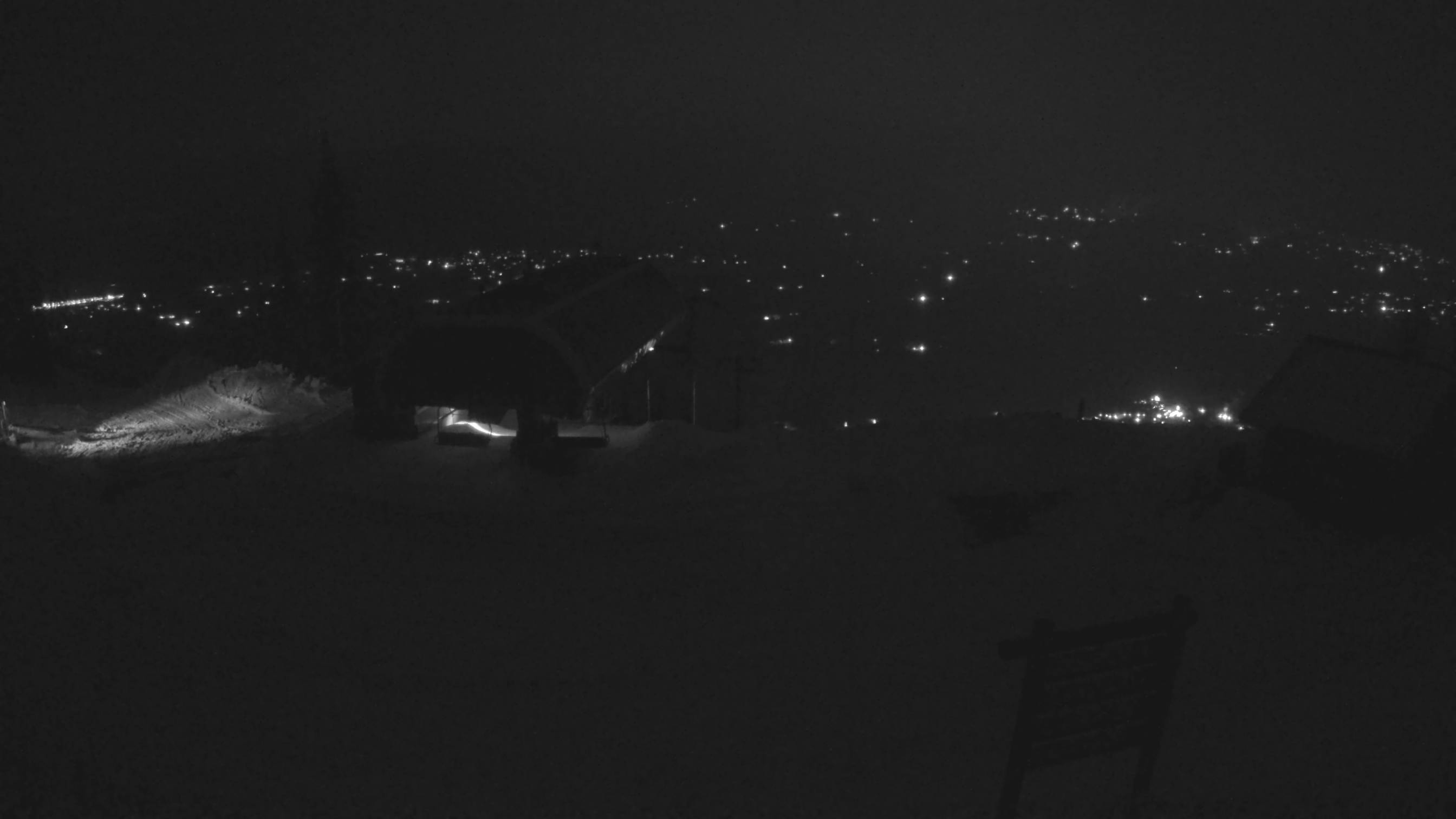
Snow King Mountain
(all SK Cams^ - sometimes offline)
The ● (red dot) should be seen at the "LIVE" feed indicator. You
may wish to change the resolution to HD if it doesn't default to
that. The YouTube address for live feeds is sometimes changed by
SeeJH.
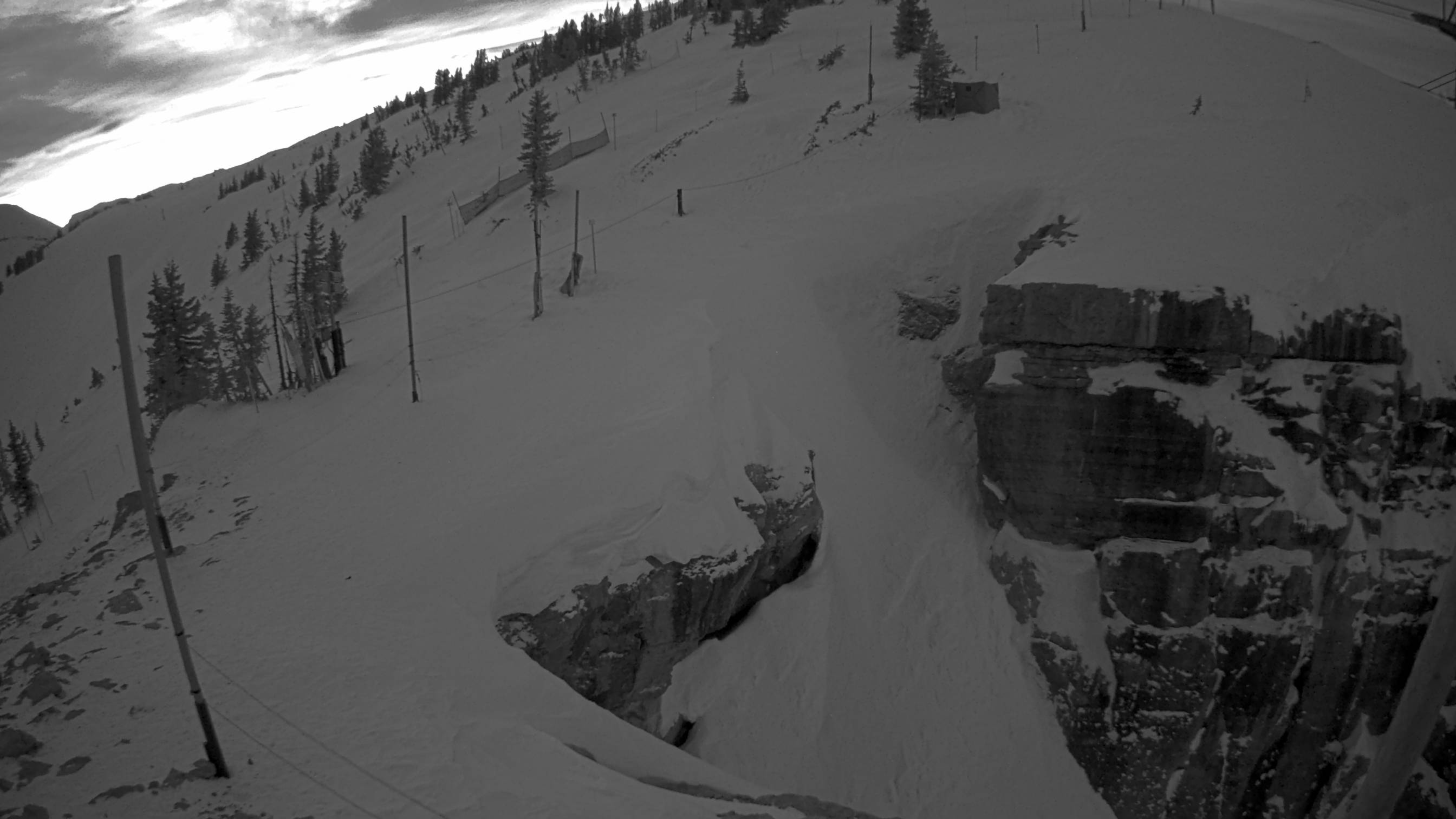
Grand Targhee Cam pans the Grand Teton
The TetonCam shows the Exum Ridge and Glencoe Spire — more of the SW
side of the Grand Teton than the Grand Targhee summit webcam. Both show the OS aspect.
~ Jenny Lake ~
Climbing Rangers
_____________________
Ranger Station Location
Ranger Station
(Summer)
307–739–3399 General Info
(GTNP's General Information)
Backcountry & Trail Conditions
Backcountry & Trail Conditions
(GTNP page is rarely updated)
Older Climbing Stuff
Older Climbing Stuff
AAC Accident & Trip Reports
(Search for "Grand Teton" in AAJ & Accidents)
(Search for "Grand Teton" in AAJ & Accidents)
The Jenny Lake Ranger Station is where you'll find the park's
climbing rangers. The station opens in early June and closes in early
September. It's operating hours are from 8:00 AM to 5:00 PM every day. We suggest calling to confirm
operating dates and hours
for any GTNP service. Dates and hours are subject to change and
sometimes the park has incorrect information on their website.
The Jenny Lake Ranger Station can be an invaluable resource for
information about mountaineering routes, conditions and backcountry hikes. The rangers don't always have the newest beta on conditions.
Their
Instagram channel might get feedback from climbers who have more recent beta. You
could also try
Mountain Project's Forums, or other social media accounts with a hashtag search. You can check
the current snow cover via Copernicus if you're climbing during the shoulder seasons.
The ranger station is the only place for climbers to get backcountry camping permits during the summer. The rangers also provide search & rescue operations for the park. Most are law enforcement officers.
The climbing rangers are supported by many generous donations from
our community and outside of it. You can make
donations through GTNP
or through the non-profit
Grand Teton National Park Foundation.
Besides GTNP's climbing rangers, the
Teton County Search & Rescue
volunteers and Yellowstone's SAR team operate in Teton County, WY. And there's the
Teton County Idaho Search & Rescue
team on the western side of the Tetons.
Beginning in 2024, the JLCR started using the TCSAR helicopter and
integrating personnel on some missions. Jackson's TCSAR gets millions of dollars in donations from the community. As
with the JLCR, TCSAR does not charge for rescue services. Donations
can be made online to the
TCSAR Foundation.
Teton County
SAR
and their partners (NPS rangers,
BTAC, BackcountryZero, etc) often host
events for backcountry users. You may find them useful.
~ Backcountry Camping ~
Grand Teton National Park
Backcountry Camping
Permits
(Reservations & Info and has ALL ZONES)
(Reservations & Info and has ALL ZONES)
(GTNP's General Information)
Safety in Bear Country
(No direct links from GTNP website, but still around)
(Old Ranger blog post)BC Trip Planner & Map
(Old GTNP pdf- no Garnet Canyon camping)
(npsmaps.com)
One-third of all summer backcountry campsites
and all group sites in Grand Teton National Park may
be reserved in advance, online, beginning in early January. Certain bivi sites located outside of camping zones are also
available for reservation.
First-come, first-served, walk-in permits are available
during the summer. Requests for those walk-in permits is often high.
Permits can be issued one day before your trip begins and no sooner. You must arrive in
person. Sometimes walk-in permits are not available for your destination. It might be that parties on multi-day trips
snapped them up over the previous days, or camping zones have
reached their occupancy limit. It helps if you're first in line the
day before your trip begins. You can try making a reservation two
days before your trip - something new in 2024, according to
Recreation.gov.
Once the Jenny Lake Ranger Station opens in June, all permits for
backcountry camping for climbers must be picked up at the
Jenny Lake Ranger Station. This includes walk-in permits and
those previously reserved online. Once the station closes in September, permits can be picked up at select visitor
centers until they close for the winter.
Winter backcountry camping permits are usually free and available
over the phone. The park's visitor centers are closed over the
winter. Come May 1, all backcountry camping permits can be picked up at the
Craig Thomas Discovery & Visitor Center
until the Jenny Lake Ranger Station reopens for the summer season in
early June.
Climbers on overnight trips must have a backcountry camping permit
to camp or bivouac; however, permits are not required for climbing.
We suspect that climbing permits have been a target of
discussion.
~ GTNP Emergency Dispatch ~
307-739-3301*
~ * 24/7 June 1 - Sept. 31 ~
~ * 6 a.m. - 10 p.m. Oct 1 - May 31 ~
* Please Confirm Hours/Dates
GTNP Emergency Procedures
For Climbers
911 works for texting in Teton County, WY & ID
307-739-3301*
~ * 24/7 June 1 - Sept. 31 ~
~ * 6 a.m. - 10 p.m. Oct 1 - May 31 ~
* Please Confirm Hours/Dates
GTNP Emergency Procedures
For Climbers
911 works for texting in Teton County, WY & ID
~
Smoke & Fire
~
~ Regional NWS Offices ~
(307) 857-3898
YouTube
NWS Jackson Weather Radio: 162.525
NWS Grant Village Yellowstone: 162.450
NWS Driggs, ID: 162.450
NWS Grant Village Yellowstone: 162.450
NWS Driggs, ID: 162.450
~ Aurora Forecast ~
Latest Aurora Forecast
- NOAA -
- UofA -
The
darkest sky
is N-NE of Jackson Lake
~ General Park Information ~
GTNP App
Climbing Information
Basic Info
307-739-3399 (or 3300)
Email:
grte_info@nps.gov
GTNP Air Quality & Live Weather
GTNP Lost and Found
307.733.3350
~ Why Free-Solo ~
For those who can safely solo this mountain on a fast and light
trip, it brings many advantages. It's faster. You can climb on
any day that fits your schedule instead of someone else's. It's
easier to make a round-trip in single day if you're soloing. You
can go at your own pace. You can leave later in the day. You can
travel further when you're carrying less weight. You'll feel stronger while climbing. You might recover more
quickly. You can focus on the rock and not on the mechanics of roped
climbing. You can skip the expensive camping permit, gear and
guide. Older, injured or physically weaker climbers may not be
able to carry gear or travel on time-lengthy trips. Stronger
climbers may not have the time for multi-day climbing
activities. You'll move faster then protected climbers and that
is often a safety advantage when the weather window is short, or
a quick escape is necessary. It's unlikely that free-soloing
climbers are delaying other climbers in a significant way and
that helps keep all climbers moving in a timely manner. It's
easier to pass other climbers when you're soloing so that you're
not delayed. You might have a smaller environmental impact in
the backcountry if you're just out for the day. You can enjoy some solitude. There's a freedom that you can't get from being tied to the
mountain or other climbers. And it's a far more enjoyable
experience for many.
To quote
Anton Krupicka: "It’s about, of course, having fun, covering a wide variety of
ground efficiently, emphasizing the movement and the
activity."
Free-soloing has its inherent,
objective dangers
as does any activity but it's relativity safe if you're climbing
within your comfort zone and taking obvious precautions like
avoiding bad weather and poor conditions. For a time, back in the
old days, solo climbing was illegal in the park but the rule was
often broken by climbers like
John Gill
who was soloing 5.10s in the Tetons. Many climbers, guides and
rangers soloed routes in the early days of Teton climbing. Today
is no different.
The best investment you can make if you wish to solo these
routes and don't mind spending some money might be buying
or renting a pair of climbing shoes. They will boost your
confidence & safety on the rock. You don't need super sticky
big wall climbing shoes for the Owen-Spalding or Upper Exum
routes. Most
approach shoes made for climbing
work fine as do several
trail running
and
mountain biking shoes. The wrong shoes will ruin a trip so if your clunky work boots
keep your feet happy on 15-mile mountain hikes, you might prefer
those over something else. Preferably boots with non-slip soles.
Most
Vibram soles
work well. There are others. Choose wisely given the objective,
your skill set and preferences. Climbing-specific approach shoes usually edge better than runners. Of course, wearing a helmet doesn't hurt.
~
Miscellaneous
~
Below are a few online resources of historical interest
connected to the Tetons. Books cover much of our climbing
history but some great mementos are down the rabbit hole,
especially visual. New history is always being written on
the web but it often disappears if left unattended.
Googler:
Noah Howell
or
Website
(^Sadly, website in poor shape)
George Gardner Scholarship Fund
George Bell
George Gardner Scholarship Fund
Alpinist Teton Women
Taylor Glenn
Miscellaneous Links
~ Water Resources ~
Taylor Glenn
Miscellaneous Links
~ Water Resources ~
FYI: The above graphic has been using Pacific Time, not
Mountain Time for the "latest" temp reading.
Time.gov
Water temps at Jenny Lake might be available by calling the Jenny Lake Boating team. They have a water thermometer by the boat dock (webcam). Summer only. Climbers engaged in The Picnic (AKA the Grand Teton Triathlon) like to track water temps for their swim across Jenny Lake. A few climbers like to take a refreshing dip after their climb. A dirt road splits off of the Lupine Meadows Road immediately after passing the bridge over Cottonwood Creek. It goes north to the Jenny Lake Boat Launch area. You can take a quick dip to cool off or clean up but it's not for swimming.
Water temps at Jenny Lake might be available by calling the Jenny Lake Boating team. They have a water thermometer by the boat dock (webcam). Summer only. Climbers engaged in The Picnic (AKA the Grand Teton Triathlon) like to track water temps for their swim across Jenny Lake. A few climbers like to take a refreshing dip after their climb. A dirt road splits off of the Lupine Meadows Road immediately after passing the bridge over Cottonwood Creek. It goes north to the Jenny Lake Boat Launch area. You can take a quick dip to cool off or clean up but it's not for swimming.
@ Jackson Lake Dam ↑ - 6777'
Inside GTNP
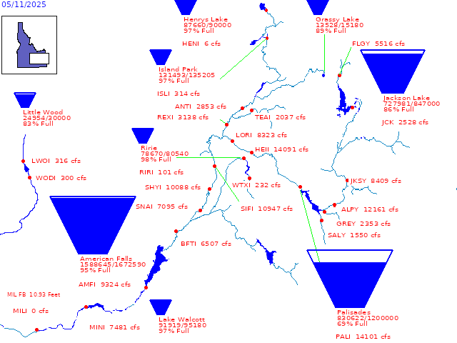 Snake River Reservoirs
Upper Snake River BasinInside GTNP
~~~~~~~
Gros Venture River
Buffalo Fork
Pacific Creek
Green River at Warren Bridge
Salt River
Hoback River below Camp Cr
MESONET
Gros Venture River
Buffalo Fork
Pacific Creek
Green River at Warren Bridge
Salt River
Hoback River below Camp Cr
Snow/SWE/Water↑
~~~~~
If Jackson Lake is really low, the western banks of the lake
can be used to access some of the trailless bushwhacking
areas north of Mt Moran. Bring bear spray and a mountain man
sensibility.
~River Webcams~

Enjoy Safe Climbing