Camping Guide
for Public Lands

• Grand Teton National Park
(307) 739-3399
GTNP's Moose Visitor Center
Moose, WY 83012
• Yellowstone National Park
Home Page
Home Page
Office & Visitor Center
340 N. Cache
Jackson, WY 83001
(307) 739-5400
BTNF Blackrock Ranger District
Jackson, WY 83001
(307) 739-5400
Office Hours
Monday - Friday
8:00 am - 4:30 pm
BTNF Blackrock Ranger District
Office & Visitor Center
Moran, WY 83013
(307) 543-3900
(307) 543-2386
(307) 543-2386
Office Hours
Monday - Friday
8:00 am - 4:30 pm
Monday - Friday
8:00 am - 4:30 pm
NEW OFFICE IN 2025
Driggs, Idaho
(208) 354-2312
Office Hours
Monday - Friday
8:00 am - 4:30 pm
(208) 354-2312
Office Hours
Monday - Friday
8:00 am - 4:30 pm
Monday - Friday
8:00 am - 4:30 pm
~~~~~~~~~~~~~~
• Jackson Hole
532 N. Cache St.
Jackson, WY 83001
Jackson, WY 83001
(No listed phone number)
Many websites and apps cover every camping and lodging option in the valley.
Travel Maps


 A few of the many
airports surrounding Jackson Hole
A few of the many
airports surrounding Jackson Hole Distances are driving distances
There are at least 9 airports within 60 or so miles of Jackson Hole and many
more non-commercial airstrips. Some nearby airports with instrument
procedures are shown below.
KDIJ -
Driggs-Reed Memorial Airport (18 nm NW, ID)
KRXE - Rexburg-Madison County Airport (48 nm W, ID)
KAFO - Afton's Municipal Airport (55 nm S, WY)
KIDA - Idaho Falls Regional Airport (58 nm W, ID)
KPNA - Pinedale's Ralph Wenz Field Airport (63 nm SE, WY)
KRXE - Rexburg-Madison County Airport (48 nm W, ID)
KAFO - Afton's Municipal Airport (55 nm S, WY)
KIDA - Idaho Falls Regional Airport (58 nm W, ID)
KPNA - Pinedale's Ralph Wenz Field Airport (63 nm SE, WY)
^distances are flight line^
Apparently, The Greater Green River Intergalactic Spaceport
is the closest
accredited facility for Intergalactic visitors.
Let's look at some maps that show campground options in each National Forest. We will look at free dispersed camping options later.
Bridger-Teton National Forest

Bridger-Teton National Forest Campgrounds
Older Map
The BTNF's Box Creek, Angles, and Red Hills campgrounds were not in service in 2024.
The Bridger-Teton National Forest has first-come, first-served
options at almost all fee-based campgrounds, and at ALL of their free dispersed camping
locations. Usually, the large-group sites, and cabins, can be reserved in advance. There are at least 260 road-accessed and authorized Forest
Service campsites north of Jackson on the Bridger-Teton. Many
other camping spots (free
or
fee-based) are outside of the valley.
There's a Forest Service website with an
interactive USFS map
that is a nice portal for maps and information. There's also the
Forest Service App
& the very nice Avenza Mapping App
for viewing GeoPDFs — download free
FS MVUM maps from inside the app.
Shoshone National Forest

Shoshone National Forest
Southern District Campgrounds
There are several dirt parking lots just off highway 26/287 heading to Jackson. One is near the Brooks Lake turnoff and another is further west. One has a pit toilet. Both are located in the SNF just before you cross over into Teton County and the BTNF. They're mostly used by snowmobiling sledheads during the winter but you can car camp overnight if need be. There's a picture of one parking lot further down the page. And they show up on Google Maps.
Caribou-Targhee National Forest

NW Wyoming & SE Idaho Campgrounds
Yellowstone National Park

Grand Teton National Park

BTNF, GTNP & CTNF Campgrounds
Click or tap to enlarge
You'll find
the main visitor center, administration offices, park housing, a Snake River boat launch, a post
office, and the Dornan's shopping and dining area at the Moose entrance to the park, just north of the
Jackson Hole Airport.
Grand Teton National Park
~ Backcountry & Lake Camping ~
(Newer but no Garnet Canyon Zones in early 2025)
(Old Ranger's Blog)
Old BC Trip Planner & Map
(pdf - no Garnet Canyon)
(pdf - no Garnet Canyon)

First-come, first-served, walk-in permits are available during the summer. Requests for those walk-in permits is often high. Permits can be issued one day before your trip begins and no sooner. You must arrive in person. Sometimes walk-in permits are not available for
your destination. It might be that parties on multi-day trips snapped
them up over the previous days. Or camping zones have reached their
occupancy limit. It helps if you're first in line the day before your
trip begins.
Advanced reservations can be made up to two days before the start of a backcountry trip. If you have any questions about permits or require trip planning assistance, please contact a ranger at Grand Teton National Park (307) 739-3309.
Winter
backcountry camping permits are usually free and available over the
phone. The park's visitor centers are closed over the winter. All backcountry camping permits can be picked up at
the
Craig Thomas Discovery & Visitor Center once it reopens in the spring. Climbers must pick up permits at the Jenny Lake Ranger Station once it reopens for the summer season in early June.
Climbers
on overnight trips must have a backcountry camping permit to camp or
bivouac; however, permits are not required for climbing.
Here's another look at Lake Camping options and the Headwaters area.
Here's another look at Lake Camping options and the Headwaters area.

GTNP Lakeside Campsites & Campgrounds map
Grassy Lake road campsites are still free, first-come, first-served as of 2026 - see top of map. They are in short supply and they're usually filling up quickly if someone leaves a campsite. Natural water sources are by the Grassy Lake camping
spots and they may need filtering. Hot springs
aren't too far away either (see GTNP rules). Carry bear spray - prime grizzly country. The road conditions can
be 4X4-Truck-Worthy the further west you travel on the Grassy Lake
Road (summer-travel only).
The
Flagg Ranch & Headwaters area
is the inside the GTNP-managed JD Rockefeller Memorial Parkway. It has a campground, lodging and free showers for campers staying at their campground. The fee-based
Sheffield Creek camping site
in the Teton National Forest is just south of Flagg Ranch. It's not
shown on the map. Campers' cars must ford a creek to reach the
campground. The creek is very passable with dry weather and low water levels by small cars.
The backcountry and frontcountry lake sites are popular in GTNP.
Try booking a reservation in January.
~ More Information - Valley Camping ~

 The "Large RV spot" is the free Moran Vista RV camping location

Free Camping close to GTNP
On the BTNF
Click or tap to enlarge

Click or tap to enlarge
• The free Blackrock Meadows Trailhead & RV Camp is a dirt parking lot that is located
15 miles east of Moran junction, or ½ mile west of Togwotee Mountain
Lodge on the north side of HWY 26/287.
• The free Spread Creek gravel pit is a big dirt parking area
at the Forest Service boundary with GTNP. It is good for big RVs. The
Spread Creek road is south of Moran between the Moose Head Ranch and
the Cunningham Cabin historical site. It's an east turn onto the dirt road off of HWY
26/89/191.
It's wise to check with the BTNF about road conditions and how
well your large vehicle will manage the challenges at any camping location. Even 'recommended'
places are often unsuitable for travel under some circumstances. BTNF message boards are located near the entrances to dispersed
camping areas. They show maps and rules for dispersed areas
The camping sites along the Toppings and Spread Creek roads can be approached via different ways. The Spread Creek Rd goes
to the Moran Vista gravel parking area. Beyond the Moran Vista RV site, the road is not very suitable for large RVs. Large RVs may also have trouble on parts of the Toppings Lake Road.
Free
camping locations fill up quickly during the summer. You may
get lucky. It's not always super crowded. A 5-day stay limit is in
effect from May 1st through Labor Day on the Bridger-Teton's Jackson Ranger District and parts of the Blackrock Ranger District (Moran area). Call 307-739-5500 for updated details.
As
of winter 2025, no user permits are required to use the national forest
for dispersed camping but that may change. The BTNF has a radio
broadcast on 1710 AM to broadcast pertinent travel information but the
broadcast is often worthless for travel updates, hazards, closures, etc.
~ Showers ~
Inside the park, showers are available at Colter Bay Village and the Signal Mountain Lodge RV Park. They start around $5 or so (2025). Headwaters/Flagg Ranch has showers for tent campers that are free if you stay at the campground. In the Town of Jackson, the Teton County recreation center has a pool, showers, climbing wall, etc. You could always take a summer dip in a river, creek, lake or pond. In 2026, the Climbers' Ranch said that they aren't providing showers for non-guests.


Prices may have changed for some camping options. Blackrock & Moran Vista are just big dirt parking lots.
On the above list is a campground number for each location. A map with the campground number is shown below....

There are many great places to see some beautiful public lands but it takes effort, and often local knowledge gained from experience, to nail down your
best options for any given time of day, time of year, type of vehicle and desired location. If you want to avoid crowds, good luck. It's busy during the high season.


BTNF Campgrounds in Jackson & South of Jackson - Fee Charged
Developed Campgrounds
Atherton
(Gros Ventre)
Crystal Creek (GV)
Pacific Creek Via GTNP & North of Moran
Sheffield Via GTNP & North of Moran
Crystal Creek (GV)
Pacific Creek Via GTNP & North of Moran
Sheffield Via GTNP & North of Moran
Hatchet
(East of Moran)
Turpin Meadows (East of Moran)
East Table (Snake River Canyon)
Station Creek (SRC)
Hoback (Hoback Canyon)
Turpin Meadows (East of Moran)
East Table (Snake River Canyon)
Station Creek (SRC)
Hoback (Hoback Canyon)
Kozy Campground
(HC)
~~~~~~~~~~~
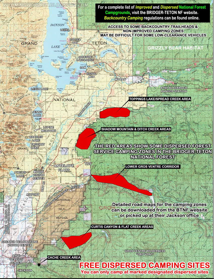
Many free dispersed camping areas in the valley have designated sites
for camping. You can't camp anywhere you want. There are specific
sites for each vehicle. Again, they fill up quickly.
BTNF Motor Vehicle Use Maps
The Bridger-Teton MVUM Maps
The maps below are Motor Vehicle Use Maps we edited. If you click on the map, you can download the enlarged
version. It's best to download the actual unedited newest maps from the Forest Service website.
Those FS maps have more information about each Forest
Service road and regulations, and have embedded GPS coordinates to
help you track your location. They're
GeoPDFs. The MVUMs are updated fairly often so be sure to get the latest map
(always free - printed or pdf). The free Avenza software for using the GeoPDFs is available for download through Avenza System Inc: www.avenza.com/pdf-maps or your app store.
Again, signage is usually placed at dispersed camping
locations.

BTNF JACKSON RANGER DISTRICT MVUM
Click or tap to enlarge all MVUM maps

BTNF BLACKROCK RANGER DISTRICT MVUM
Click or tap to enlarge all MVUM maps
BTNF Remote Camping & other quirks
These are trails in the BTNF that can be used to access more remote
camping. The
BTNP List Of Backpacking Trails. And here is the
BTNF List Of Horse Camping Locations.
West of the Continental Divide along the Togwotee Pass highway is a BTNF National Forest parking area called Vista View
which,
currently, has no signs prohibiting overnight parking.
They're handy if you don't have a suitable car for off-road travel on
Forest Service roads. The "scenic view" highway pullout with pit toilets just above Togwotee Mountain Lodge
doesn't allow overnight camping. Just below the lodge is the previously mentioned
snowmobile dirt parking lot (the Blackrock Meadows camping area) with a pit toilet. You'll see a big sign for the
parking area. You can get a meal at the lodge.
CTNF Motor Vehicle Use Maps
The Caribou-Targhee MVUM Maps
 CTNF - TETON BASIN RANGER DISTRICT MVUM
Click or tap to enlarge all MVUM maps
Popular Campgrounds in the CTNF's
Teton Basin District
Teton Basin District

Fee-based Campgrounds in the CTNF
Notice that the CTNF's Teton Basin Ranger District is in Wyoming & Idaho. And on the western side of the Tetons.
The CTNF's Mike Harris camping area is in Idaho and near the WY-ID
border. It is just off the highway that takes you to Jackson via
Teton Pass. A little further east of that camping area but on the Wyoming side is the CTNF's Trail
Creek Campground. They're the closest CTNF campgrounds to access the eastern side of the
Tetons via car and Jackson Hole.
You can make a reservation for several
CTNF campgrounds.
Here's a camping tip for private plane owners: The Driggs-Reed Memorial Airport (KDIJ), located on the Idaho side of the Grand Tetons and by the CTNF, has a grass tie-down area for under-wing camping.

..not everyone owns a jet, and one hundred low lead is expensive
SNF Motor Vehicle Use Maps
Shoshone National Forest MVUM Maps
 Shoshone National Forest MVUM
(near Teton & Fremont County Boundary)
Click or tap to enlarge all MVUM maps
The Shoshone National Forest (America's first national forest)
has
5 Ranger Districts. If you look on their website, you'll see
north & south zone maps. The north zone map shows the Clarks Fork, Greybull, and Wapiti
Ranger Districts. And the south zone map (side 2 seen above)
shows the Washakie and Wind River Ranger Districts. The Wind River
Ranger District is administered from Dubois, Wyoming (maybe 1 hour from GTNP). The Washakie Ranger District is administered from Lander, Wyoming.
SNF Ranger Districts Tele Numbers.
We'll mention once again an option along the highway in the Shoshone National Forest between the top of Togwotee Pass and Dubois. WY....
We'll mention once again an option along the highway in the Shoshone National Forest between the top of Togwotee Pass and Dubois. WY....

Typical snowmobile parking lot next to the Togwotee Pass highway
~~~~~~~~~~~~~~~
More info on
Campgrounds In GTNP
Campgrounds In GTNP

2025 Campground Opening Dates
(click on the links below to see 2025+ dates)
(click on the links below to see 2025+ dates)
Gros Ventre Campground, April 26 - October 10
Jenny Lake Campground, July 1 - September 28
Signal Mountain Campground, May 9 - October 12
Colter Bay Campground, May 22 September 28
Colter Bay RV Park, May 3 - October 10
Colter Bay Tent Village, May 23 - September 1
Lizard Creek Campground, June 13 - September 8
Headwaters Campground, June 7 - October 1
Headwaters RV Park, June 7 - October 1
The campgrounds in GTNP require reservations
Lodges in GTNP
Dornans
(private inholding)
(Run by
Vail Resorts)
(Jackson Lake Lodge, Jenny Lake Lodge, Colter Bay Village, Headwaters Lodge and Cabins)
(Jackson Lake Lodge, Jenny Lake Lodge, Colter Bay Village, Headwaters Lodge and Cabins)
Triangle X Dude Ranch (private inholding)
Moose Head Ranch (private inholding)
The AAC Climbers' Ranch
in GTNP has rustic cabins with bunk beds. The ranch is south of the
Lupine Meadows trailhead. You might get a last-minute reservation there
but you might not get much sleep in a shared bunk cabin.
GTNP Backcountry Camping Policies & Details
The latest policies and details can be found on Recreation.gov
Permit Fee: $20 flat fee per permit (non-refundable) plus...
Nightly Fee: $7 per person, per night (refundable until five days before the permit start date)
Change Policy
Once a reservation has been made no changes can be made by the
customer. Contact the Grand Teton National Park Permits Office at
(307) 739-3309 for assistance.
Cancellation Policy
Once a permit reservation is completed, it is non-refundable. As a
courtesy to others, please notify the park as soon as possible if
you decide not to use your reservation.
No Show Policy
If the permit is not picked up by 10:00 a.m. MT the day of arrival,
the customer will be considered a "no show." The permit will be
canceled and is not refundable.
You may call to inform us, (307) 739-3309, if you'll be late to collect your permit.
You may call to inform us, (307) 739-3309, if you'll be late to collect your permit.
Permit and Season Information
A permit is required for all backcountry camping
trips in Grand Teton National Park. All persons who intend to sleep
overnight, camp, or bivouac in the backcountry, or who are in
possession of equipment designed for overnight use in the
backcountry, must obtain a backcountry permit and carry it with
them. Permits are used to minimize the impact on park resources, and
backcountry camping permits are limited.
One permit can include up to 10 consecutive nights of stay in
multiple campsite zones. Once you have determined the areas you
would like to visit during your backcountry trip you'll need to
reserve a campsite for each night. One-third of all
backcountry campsites and all of the group sites may be reserved in
advance, online, beginning the first Wednesday in January through
May 15. The remaining sites are filled on a first-come, first-served
basis in person at park permit offices no more than one day before
the trip begins.
The permit is valid only for the number of people, dates and
locations indicated. Campers must use all nights on a permit for the
permit to remain valid.
Important Dates
Advance backcountry permit reservations can be acquired in early January for the coming season.
Backcountry camping permits are only available in person on a first-come first-serve basis. All summer permits for backcountry camping while climbing must be picked up from the Jenny Lake Ranger Station during the summer. You can pick up permits during the summer one day ahead of your trip (if available). Call to check on availability the afternoon before your arrival. Starting in 2024, the option to make a last-minute reservation 2 days before your trip began if unused permits were still available — permits previously set aside for advanced reservations only.
Backcountry camping permits not involving climbing are available at
the Craig Thomas Discovery and Visitor Center in Moose, the Colter
Bay Visitor Center, and the Jenny Lake Ranger Station. Check
location for hours and seasonal dates. Visitor centers are closed
during the winter
Quotas For Backcountry Permits
Within Grand Teton National Park, backcountry camping is managed
with quotas for designated sites and camping zones. The party size,
length of stay, and the number of people or parties allowed in a
camping zone per night, have been calculated and regulated to
provide for resource protection and visitor enjoyment.
Individual parties consist of one to six people,
and may use lakeshore campsites, designated mountain campsites and
mountain camping zones. Zones are marked with a sign on each end and
hikers with a valid permit have the freedom to choose where they
wish to camp once arriving at the zone, although occupying
previously used campsites is strongly encouraged.
Groups consist of
seven to 12 people and must
camp in designated group site. Large groups may not split into
smaller groups and camp in the same zone together.
Early Season Snow Conditions
Snow usually melts from valley trails by
mid-June but remains in parts of the high country through much of
the summer, especially shaded areas. Safe travel over Paintbrush, Static Peak and Moose Basin
Divides, and Hurricane, Mt. Meek and Fox Creek Passes requires an
ice axe and knowledge of its use as late as August. Snow conditions
vary from year to year. If you are planning to cross any divides
before late July, and do not have the skills for safe use of an ice
axe on steep snowfields, consider an alternate route. Crossing a
divide or pass is essential when traveling on the Teton Crest Trail
and for loop trips. However, there are still opportunities for a
rewarding "in and out" trip utilizing any of the major canyons.
Weather can be extreme and change rapidly, impacting climbing trips
to the Teton Range. It's important to check current local weather
and mountain conditions prior to your visit.
Bear Country
All backcountry campers are required to carry Interagency Grizzly
Bear Committee approved bear canisters unless a bear proof metal box
is installed at the campsite. Canisters can be checked out at all
permit issuing stations free of charge with a backcountry
permit.
Plan Your Backcountry Trip Carefully
Consider how many miles you want to go each day, how much elevation
change, and keep in mind the skill levels of all the members of your
group. Use the Backcountry Planning Map to examine each night of
your trip's point to point mileage (Garnet Canyon mileage was still absent in 2025). Elevation high points are
indicated on this map. For more specific information, consult a
topographic map or hiking guide. Review the Backcountry Camping
Areas for a description of camping zones and sites.
We encourage all backcountry users to pack out what they pack in
including packing out human waste from this fragile alpine
environment. Bags are made available to those who are camping at the
Lower Saddle and the Caves campsites in Garnet Canyon from the JLCR.
Permits are subject to review and violations may result in the
permit being revoked.
Additional Information
Recreation.gov GTNP Permits
Reserve
Backcountry Planning Map (pdf)
Grand Teton National Park Website
Ranger's Teton Climbing Blogspot
Jenny Lake Ranger Station
Interagency Grizzly Bear Committee
Backcountry Planning Map (pdf)
Grand Teton National Park Website
Ranger's Teton Climbing Blogspot
Jenny Lake Ranger Station
Interagency Grizzly Bear Committee
If you have any questions about permits or require trip planning
assistance, please contact a ranger at Grand Teton National Park
(307) 739-3309.
GTNP Backcountry Camping Areas
Jackson Lake Camping: The sites along the shores of Jackson
Lake, many are accessible only by boat.
Leigh Lake Camping: The sites along the shores of Leigh Lake,
accessible by canoe, kayak, or foot.
Mountain Group-Camping: All individually marked group sites for 7 to 12 people within the major camping zones.
Northern Canyons Camping: The areas within Webb Canyon/Moose Basin, Berry Creek Canyon, and Owl Canyon.
South Fork Garnet Canyon: The climber/bivy camping zone for accessing climbs in the South Fork of Garnet Canyon (Middle & South Tetons)
Meadows & Platforms: The climber/bivy camping zones in the main fork of Garnet Canyon.
Lower-Saddle, Moraines, and Caves: The climber/bivy camping zones for accessing the Grand Teton and other nearby climbs. The camping zones are in the north fork of Garnet Canyon.
Technical Climbing Sites: The climber/bivy sites for technical mountaineering objectives.
Food Storage Notice
(For Leigh Lake/Bearpaw Lake/Trapper Lake and Jackson Lake permit
holders)
The Leigh Lake and Jackson Lake areas are very popular destinations for campers and day hikers and are also home to black and grizzly bears. Occasionally campers arrive at their Lakeshore campsite with more food than the provided bear-resistant food storage devices can accommodate. As a result, bears in the area have received human food rewards from improperly stored food. This has led to food conditioned and often habituated behavior by bears, and aggressive actions that make them dangerous to people. When this occurs, bears must be destroyed.
Bear conservation, your safety and that of others are at stake. Please help us in our efforts to protect bears by adhering to the following rules and guidelines:
All food, garbage, drinks, and any item with an odor must be stored in a bear-resistant food storage locker (bear box) or Interagency Grizzly Bear Committee (IGBC) approved canister when not in immediate use. Grand Teton National Park provides IGBC approved bear canisters at no charge.
Coolers, cans, bottles, etc., are not bear-resistant and must be stored properly.
The bear boxes provided measure approximately 48 x 20 x 20 inches and can typically accommodate one medium-sized cooler and enough food for several days.
Food items may not be hung in trees or left in boats. Light items can be hung on bear poles where provided and must be a minimum of 10’ from the ground.
Items that cannot be properly secured must be returned to your vehicle. Remember to secure food items in the provided bear boxes when portaging between String and Leigh Lake. Secure all food items immediately upon arrival at your campsite.
Backcountry Camping
In Garnet Canyon
In Garnet Canyon

Garnet Canyon water & camping zones
(water only shown along the climbers' trail to Lower Saddle)
Check our webpage covering the approach to the Lower Saddle for more information.
OLD Published Distance
(GPS values differ on distance)
4.1 miles to Platforms Camping Zone at Garnet Creek
4.7 miles to Meadows Camping Zone
5.5 miles to Petzoldt's Caves Camping Zone
6.2 miles to Morainal Camping Zone
7.0 miles to Lower Saddle
GPS Tracks Distances
First Junction: 1.7 miles
Second Junction: 3 miles
Platforms Camping Zone: 4.1 miles
Platforms Camping Zone: 4.1 miles
Meadows Camping Zone: 4.5 miles
Caves Camping Zone: 5.2 miles to spring water
Moraines Camping Zone: 5.9 miles to sign
Lower Saddle: 6.4 miles
GPS tracksCaves Camping Zone: 5.2 miles to spring water
Moraines Camping Zone: 5.9 miles to sign
Lower Saddle: 6.4 miles

Common Backcountry Camping Sites for Grand Teton Climbers - 2024
The above map is from the recreation.gov website where you can book a reservation and examine backcounry permit rules.

Popular sites in Garnet Canyon for climbers heading up the Grand Teton
The interactive backcountry camping map on the GTNP website does NOT include Garnet Canyon as of 2025. The recreation.gov site does: List of GTNP Backcountry Permit Sites
Special Rules for Garnet Canyon
Garnet Canyon Stay Limits
Parties are limited to two nights per fork of the canyon (Lower
Fork, South Fork, North Fork), with a maximum stay of six nights per
outing. Between June 1 and September 15, campers may stay in
the backcountry of Grand Teton National Park a maximum of 10 nights.
Party Size
All camping in Garnet Canyon is limited to parties of 1 to 6 people. Call for information about group camping involving more than 6 people.
Human Waste Disposal
All overnight campers at the Lower Saddle & Caves Camping Zones are required to take "Rest Stop" bags to pack out their human waste. Campers are also encouraged to use "Rest Stop" bags when staying elsewhere in Garnet Canyon. Bags are available for issue with a camping permit at the Jenny Lake Ranger Station. Semi-permanent plywood structures on the west side of the Lower Saddle help to facilitate use of the bags. Chemical polymers breaking down the solid waste allow for the bags to be deposited in any garbage can back on the valley floor. Additional information on proper use can be obtained at the Jenny Lake Ranger Station. We also request that people urinate on the west side of the Lower Saddle to help maintain a clean and pristine camping area and to prevent contamination of the water source on the east side.
Food Storage
All food, garbage, toiletries, and any other odorous item that may attract bears or other wildlife MUST be stored in a bear-resistant food storage canister or box when not in immediate use, day or night. Bears, marmots, ravens, and other scavengers frequent Garnet Canyon and can cause significant damage to tents, sleeping bags, packs, and other camping equipment if food and garbage is not properly stored. Approved bear-resistant food storage canisters are required at the Moraine and South Fork Camping Zones. Canisters can be checked out with a camping permit for free at the Jenny Lake Ranger Station.
Bear-resistant food storage boxes are available at the Platforms (1), Meadows (3), Caves (1), and Lower Saddle(1).
~~~~~~~~~~~~~~~~~~~~~~~
Winter Camping
Park campgrounds are closed during the winter. Primitive winter
camping is allowed on the parking lot next to the Colter Bay Visitor
Center from December 1 to April 15, with a $5 per night fee which
can be paid at the Moran Entrance Station. They used to have a fee
deposit box next to the Visitor Center restroom in case you arrived
late. It may still be there.
~~~~~~~~~~~~~~~
Miscellaneous Stuff

USGS 7.5 min
Quad Map Index
for the Tetons
GTNP Trail Maps
Granite Canyon Trailhead
Death Canyon Trailhead
Taggart Lake Trailhead
Lupine Meadows Trailhead
Jenny Lake Trailhead
String Lake Trailhead
Leigh Lake Trailhead
Hermitage Point Trailhead
Two Ocean Lake Trailhead
Death Canyon Trailhead
Taggart Lake Trailhead
Lupine Meadows Trailhead
Jenny Lake Trailhead
String Lake Trailhead
Leigh Lake Trailhead
Hermitage Point Trailhead
Two Ocean Lake Trailhead
Other Maps

Click or tap to enlarge
This map is free to download and is free at many visitor centers. It
is one of the better off-road maps. The downloadable map is in
a GeoPDF format for use with your smartphone's GPS to locate your
position on the map even when cellular service is not available.
There's also a plain PDF map available.

Click or tap to enlarge
Older Map.
The Popular Dispersed Areas


Enjoy Safe Climbing