
** Ranger's Updates on Conditions
Wyoming Whiskey Trip Reports
~ A few trip reports ~
April through October
April through October
~~~~~~~~~~~~
Travel Maps

Google has the distance from the Town of Jackson to the Lupine Meadows Trailhead at 21 miles.

(Trailhead and Grand Teton)
Click to Enlarge
The road to the Lupine Meadows Trailhead is just south of the entrance to the South Jenny Lake visitor area. There's a sign for the Lupine Meadows Junction. Google Map

The Grand Teton rises about 7035 ft above the valley floor.
During the winter season, climbers and skiers start at the Taggart Lake Trailhead instead of the Lupine Meadows Trailhead. They use backcountry skis to access Garnet Canyon. There are other ways to get into Garnet Canyon but those are the most common.
Water

Water availability along trail & by camping sites
 Water @ Jenny Lake Store
 S. Jenny Lake Area
It's about 2.5 miles by car from the trailhead to the store. There's a shortcut trail by the Exum office if you're on foot. You can access water from the creeks flowing through Lupine Meadows but they may need filtering or chemical treatment.
 A Snowy Garnet Canyon Click to Enlarge

The following times are approximate for free-soloing athletes who are moving fast (speed walking) & packing next to nothing (or very light) under good conditions....
These
are estimated times for those who truly move fast while walking. The average hiker could take much longer to get to the Lower Saddle. Everyone's different.
Trekking poles might speed up the ascents. Kilian Jornet used poles when attempting the Fastest Known Vertical Kilometer (3281 feet elevation gain—about two Snow Kings high). He took just under 29 minutes or about 14 minutes per Snow King. By comparison, his Grand Teton ascent time (without poles) from the trailhead took about 1 hour 51 minutes to rise just over 7000 ft (2147 meters). Of course, the approach is longer.

The Lupine Meadows Trailhead is named after the purple colored Silver Lupine flowers which are a common sight in the adjacent meadows. Besides being the most popular trailhead for Grand Teton climbers it's also a popular trailhead to several lakes. There's also an unmarked trailhead for Teewinot Mountain that's north of the vault toilet. Besides climbers and hikers, you may see elk and antelope in the morning. Maybe a moose or fox. Possibly deer or a bear. The garter snake is the only snake that most people ever see in Jackson Hole. It's highly unlikely you'll see one while climbing. According to Grand Teton National Park, the wandering garter snake, the valley garter snake and the rubber boa are the only snakes hanging out in the park, usually near waterways.


The parking area starts getting busy around 5 a.m. during the peak climbing season. It will be busier on the weekends. It's often overflowing with cars parked along the access road by noon. The dirt road to the trailhead is sometimes a washboardy, potholy mess that will eat your suspension.
The trail departing the trailhead is part of The Valley Trail that runs along the base of the Tetons.
 First Junction
 Burned Wagon Gulch Trailhead
Back to our standard trail....
 Water above 1st Junction

After a bunch of switchbacks, you'll find yourself at another junction which is 3 miles from the trailhead. You'll get here in an hour or less from the trailhead if you're moving quickly (most aren't). Head southish on the Garnet Canyon Trail. The trail starts to flatten with no more switchbacks until you're further inside the Garnet Canyon.

Early in the climbing season, and about 3.6 miles from the trailhead, you'll find a strong flow of water crossing the trail before you reach Garnet Creek. It's flowing from the unseen Surprise Lake. We drink it unfiltered when the flows are strong but animals can still contaminate it. The water eventually stops running during the summer. The dates change yearly.
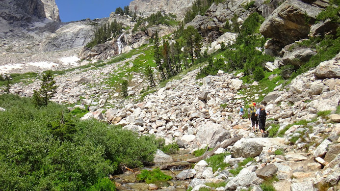
 On the approach with JHHS Mountaineering Club

 General direction of guided travel when dry

 The slabs here can be very slick when wet, or if your soles are wet
 Exiting the 1st Boulder Field - ascent
 Looking back
.JPG) Entrance to the Meadows Camping Zone
Entrance to the Meadows Camping Zone
 Break time by the Meadows
 Head for the switchbacks by Spalding Falls


Free potable water is available at the South Jenny Lake Store 24/7 during the
summer. The Jenny Lake Ranger Station is also near the store. The station issues all camping permits for climbers. It's staffed by the Jenny Lake Climbing Rangers.

It's about 2.5 miles by car from the trailhead to the store. There's a shortcut trail by the Exum office if you're on foot. You can access water from the creeks flowing through Lupine Meadows but they may need filtering or chemical treatment.


Approach to the Lower Saddle
(shows total distance near 6.3 miles)
This hiker was jogging or walking very quickly when they started. It looks like they petered out after 4 miles of hiking.
Strava's webpage for the hike to the Grand's Lower Saddle shows the distance to the saddle at 6.1 miles. They have downloadable GPS tracks, as does GAIA GPS. Teton tracks used to be on Suunto's MovesCount.com website before the website was discontinued. Their app may have shared routes. We haven't tried it. Mountain Project has its map. And there's AllTrails, Trailforks, CalTopo, OpenStreetMap, etc. The major hiking apps cover the trail too.
Do you need a GPS track to find your way? Not so much during the day. It can be helpful at night.
~ Hiking Times ~
The following times are approximate for free-soloing athletes who are moving fast (speed walking) & packing next to nothing (or very light) under good conditions....
First Junction: 30 minutes, 0.5 hrs total, 1.7 miles
Second Junction: 30 minutes, 1 hr total, 3 miles
Platforms Camping Zone: 4.1 miles
Platforms Camping Zone: 4.1 miles
Meadows Camping Zone: 30 minutes, 1.5 hrs total, 4.5 miles
Caves Camping Zone: 5.2 miles to spring water
Moraines Camping Zone: 5.9 miles to sign
Lower Saddle: 60 minutes, 2.5 hrs total, 6.4 miles
Caves Camping Zone: 5.2 miles to spring water
Moraines Camping Zone: 5.9 miles to sign
Lower Saddle: 60 minutes, 2.5 hrs total, 6.4 miles
Trekking poles might speed up the ascents. Kilian Jornet used poles when attempting the Fastest Known Vertical Kilometer (3281 feet elevation gain—about two Snow Kings high). He took just under 29 minutes or about 14 minutes per Snow King. By comparison, his Grand Teton ascent time (without poles) from the trailhead took about 1 hour 51 minutes to rise just over 7000 ft (2147 meters). Of course, the approach is longer.
~ Lupine Meadows Trailhead ~
The Lupine Meadows Trailhead is named after the purple colored Silver Lupine flowers which are a common sight in the adjacent meadows. Besides being the most popular trailhead for Grand Teton climbers it's also a popular trailhead to several lakes. There's also an unmarked trailhead for Teewinot Mountain that's north of the vault toilet. Besides climbers and hikers, you may see elk and antelope in the morning. Maybe a moose or fox. Possibly deer or a bear. The garter snake is the only snake that most people ever see in Jackson Hole. It's highly unlikely you'll see one while climbing. According to Grand Teton National Park, the wandering garter snake, the valley garter snake and the rubber boa are the only snakes hanging out in the park, usually near waterways.

Hanging out in Lupine Meadows below Teewinot
Car break-ins happen inside the park. As with any
trailhead, you should hide and lock up valuables. Also, it's common to run into black bears and deer on the trail if you're up here often. Most will ignore you or move away.
The typical winter approach from the Taggart Lake
Trailhead is discussed near the very bottom of this webpage. The rarely used Burned Wagon Gulch trailhead is discussed shortly.

The Lupine Meadows trailhead parking lot
The parking area starts getting busy around 5 a.m. during the peak climbing season. It will be busier on the weekends. It's often overflowing with cars parked along the access road by noon. The dirt road to the trailhead is sometimes a washboardy, potholy mess that will eat your suspension.
The trail departing the trailhead is part of The Valley Trail that runs along the base of the Tetons.
~ Heading Out ~
It's about 1.7 miles to reach the first junction after leaving Lupine Meadows. Maybe 30 minutes or less if you're walking quickly.

Don't follow the Valley Trail to Bradley Lake at the first junction. And don't go toward the lakes at the second junction either! Happens way too often. The trail above the first junction is the Garnet Canyon Trail. You're heading for Garnet Canyon.
On the north side of this junction is Glacier Gulch. On the south side is the Burned Wagon Gulch. An unmarked trail runs down the Burned Wagon Gulch. It's location is highlighted above and below.....

The Burned Wagon Gulch trail starts along the
road leading to the Climbers' Ranch. You'll see the very small pullout just
after crossing the bridge over Cottonwood Creek. Maybe 4 parking spaces. The Burned Wagon Gulch trail takes you within 500 feet of the Lucas Homestead. It also takes you right next to the Geraldine Lucas Memorial Gravesite (you'll see a plaque atop a large boulder in an open field). She was the 2nd woman to climb the Grand Teton, and the first local woman to do so.
We prefer the Burned Wagon Gulch trail during May & early June when it's free of snow and the lower Lupine Meadows trail is still melting out. The trail is sometimes overgrown and you may get soaked if dew is on the vegetation. Perhaps there's a greater chance of ticks.
The Park Service doesn't maintain the BWG trail very often but it's a good usable trail. It takes slightly more time to reach the first junction from the BWG trailhead compared to the Lupine Meadows trailhead. There's always the possibility of some flooding near the mouth of the gulch as snow melts off (head north to circle around it). The trail starts along the north slope (south face) of the gulch and avoids the low lands down the center.
You may want bear spray along the BWG trail early in the season because the trail sees less foot traffic and it goes by Cottonwood Creek which grizzly bears occasionally visit.
Back to our standard trail....

Just above the first junction are three sources of water which cross the
trail. The first source dries up after the snow melts at
elevations above it. It should probably be filtered. It
has the strongest flow in June (time varies yearly) and it has a modest cascade during its peak. It completely dries up before the summer high season.
The next two sources are tiny trickles of seepage water that run all summer long. Many people drink the water unfiltered. Both sources are just above the grade of the trail along the first switchback. You can't miss them. They have their uphill 'tanks' exposed during the spring season (super-saturated to the surface) and animals often congregate directly above the location you plan to drink from so you may wish to avoid these water sources early in the season.
The next two sources are tiny trickles of seepage water that run all summer long. Many people drink the water unfiltered. Both sources are just above the grade of the trail along the first switchback. You can't miss them. They have their uphill 'tanks' exposed during the spring season (super-saturated to the surface) and animals often congregate directly above the location you plan to drink from so you may wish to avoid these water sources early in the season.
Between the first and second junction is an old climbers' trail which is closed for rehab (there's a sign). There's barely a 60-second difference on the ascent between the two trails if you're in a hurry so there's usually no good reason to poach the old trail. There are several other shortcuts on the approach. One is just past this junction (no sign). They have been used for decades but......
The National Park Service has emphasized that cutting
switchbacks on the maintained route is a violation of the park service regulation
36 CFR 2.1(b), "Shortcutting a switchback along a trail is prohibited"
Park regulations require you to stay on a maintained trail when one's available to your destination. There's less of an issue if you're scrambling over talus or snow. Some shortcuts are not safe or efficient. Short-cutting during an emergency or for safety reasons may be a necessity. You might need to move past a bear. Some unmarked, unmaintained or unmapped trails are considered social trails which are acceptable for use. The trail into Glacier Gulch that goes up to Delta Lake is one of them (you're not headed there).

2nd Junction
After a bunch of switchbacks, you'll find yourself at another junction which is 3 miles from the trailhead. You'll get here in an hour or less from the trailhead if you're moving quickly (most aren't). Head southish on the Garnet Canyon Trail. The trail starts to flatten with no more switchbacks until you're further inside the Garnet Canyon.

Water crossing climbers' trail


GTNP Trail Crew working in Garnet Canyon 2022
The crew shown here was fixing a small slide that crossed the trail. Our unsung heroes do some masterful work.

The trail disappears for over 200 feet at the boulder field next to Garnet Creek. The Platforms Camping Zone is to your south on the other side of the creek (there's a sign). You're about 4.1 miles from the trailhead. This First Boulder Field is often called the Platform's Boulder Field. The entire canyon is a boulder & talus field but this is the first boulder field you come to where the trail momentarily disappears. The trail restarts next to the creek and you're always on the north side of the creek.
If you're camping at the Platforms Camping Zone, you'll find that the best location to cross the creek varies with its flow and ground conditions. There's a common scramble to the camping site from the sign at the
temporary end of the trail. Head slightly southwest from the sign and
scramble up to an elevated boulder and jump across Garnet Creek from
there. Or near there. Other approaches are available further up the creek. The camping zone used to have wood platforms for camping.
The trail to the Platforms was one of the first trails to be constructed in Grand Teton National Park. It was built by Civilian Conservation Corps laborers around the mid-1930's. The trail beyond there was initially scratched into the earth in 1977 by climbing ranger George Montopoli and another ranger. The guidebook says it's unmaintained past the Platforms; however, some very rare maintenance has taken place on the trail to Spalding Falls. As of 2025, Montopoli was still a climbing ranger after 48 years of service. He used to solo 5.10s in the park and set FKTs before anyone knew what an FKT was.
The trail to the Platforms was one of the first trails to be constructed in Grand Teton National Park. It was built by Civilian Conservation Corps laborers around the mid-1930's. The trail beyond there was initially scratched into the earth in 1977 by climbing ranger George Montopoli and another ranger. The guidebook says it's unmaintained past the Platforms; however, some very rare maintenance has taken place on the trail to Spalding Falls. As of 2025, Montopoli was still a climbing ranger after 48 years of service. He used to solo 5.10s in the park and set FKTs before anyone knew what an FKT was.

There will be a bootpack over snowy boulders early in the season. It's sometimes sketchy.

Typical guided path


The trail past the Platform's Boulder Field disappears in a few locations for a short distance. You'll get back on the trail quickly. It usually restarts right in front of you. Take the path of least resistance.
.JPG)
At the Meadows Camping Zone, the trail splits toward the South Fork of Garnet Canyon. Do not cross the creek like Kilian Jornet and Anton Krupicka who headed toward the Middle Teton's South Col thinking it was the Lower Saddle. A common mistake. Stay on the creek's north side.
It's about 1.5 hours from the Lupine Meadows Trailhead to the sign at the Meadows Camping Zone if you're moving quickly but not running. The Lower Saddle is about an hour away from the Meadows if you maintain a strong pace.
It's about 1.5 hours from the Lupine Meadows Trailhead to the sign at the Meadows Camping Zone if you're moving quickly but not running. The Lower Saddle is about an hour away from the Meadows if you maintain a strong pace.

The Meadows area used to be bigger. It was buried in rockfall.


View of the Meadows Camping Zone from the summer switchbacks
Let's look at some snow routes on the Meadows' Headwall before we continue with the summer trail.
Feel free to scroll past this next section if you're climbing under dry conditions.
Early-Season Snow Hazards
Hazards are everywhere with snow underfoot. A mountaineering axe is recommended for high-consequence travel over snow on the approach. Crampons may be needed with icy snow. The trail into Garnet Canyon during the spring can become a hazard for hikers unaccustomed to the conditions.
Deadly avalanches can happen throughout May. During June, snow avalanches can still happen but flushing is more common as a mix of snow, water, dirt, rocks, and ice all lose cohesion, helped along by very active freeze and thaw cycles.
Deadly avalanches can happen throughout May. During June, snow avalanches can still happen but flushing is more common as a mix of snow, water, dirt, rocks, and ice all lose cohesion, helped along by very active freeze and thaw cycles.

Sections of snow routes can be undercut by running water. And rock-snow interfaces are likely to hold unstable snow.
In June of 2013, Gary Miller was on a guided climb and descending the more-northern snow route
on the Meadows' headwall when he slipped and slid into a moat. He was consumed by freezing water. The location is highlighted below. Mark Anderson, 29, did the
same thing
in 1994. And others have done it elsewhere in the Tetons.
On June 23, 1956, "Miss Patricia King (18) made an attempt to control her glissade on the headwall when the sudden jerking of her ice axe dislocated her right shoulder. After losing control, she bounced and rolled some 70 feet through the rocks causing multiple bruises and lacerations to her entire body, particularly her head and face."
The number of snow-travel accidents that have occurred on the North Fork's slopes is high. The South Fork's slopes are no better.

Ranger examining the moat where Gary lost his life
During the
spring, we usually head by the pinch point shown above. Conditions dictate our travel path. And the path we take up the headwall may differ from the path we take
down it. It helps to have an understanding of how the snow shapes up on various
aspects as the day warms and cools. A few climbers get caught off guard
by the changing conditions.
The large elevated rock outcroppings on the headwall are not recommended as travel paths. They usually slow down climbers.
"On June 9, 2015, Charlie Emerson, 31, of Marietta, Georgia was solo climbing a 4th class rock slab above the Meadows when he slipped and slid approximately 150-200 feet before coming to rest in a snowfield at the base of the rock feature. As these rock slabs melt out, they can be covered with slippery silt or sand, which makes good traction more challenging." NPS
"On June 9, 2015, Charlie Emerson, 31, of Marietta, Georgia was solo climbing a 4th class rock slab above the Meadows when he slipped and slid approximately 150-200 feet before coming to rest in a snowfield at the base of the rock feature. As these rock slabs melt out, they can be covered with slippery silt or sand, which makes good traction more challenging." NPS
.JPG)
.JPG%20june%2023%202013.JPG)
The
climbing guides start their group trips up the Grand around mid-June. They will use the winter approach until the summer approach is safer. If you time it right, June's snow can be firm &
punchy for a speedy approach without gear. You may need gear for the climb or descent.
Spring skiers heading for the Grand Teton usually start very early in the morning to avoid hazards associated with warming weather. Those looking for corn skiing tend to wait for warming temps but waiting too long can increase the odds of avalanches. Skiing off the Grand starts gaining traction near the end of March or early April and continues through June. Activity rates vary with conditions and weather.
Factoids: 16-year-old Fred Brown and chief park ranger Allen Hanks were the first to ski into Grand Teton National Park in 1931 or '32. Paul Petzoldt, his brother Curly and Fred Brown enjoyed the first-known decent of Rendezvous Mountain in 1935, which would later become the Jackson Hole Mountain Resort. Ski industry pioneer Earl Ervin Clark cut his teeth climbing in the Tetons with the Chicago Mountaineering Club and helped set up the first ski camp in GTNP's Alaska Basin in 1941.
In 1938, the National Forest's Intermountain Region listed the following ski areas in western Wyoming: Teton Pass, Hoback Canyon, Star Valley Divide, and Jackson (on the Town Hill which became Snow King). The Forest Service indicated that Jackson's Town Hill offered three ski jumps of various sizes in addition to a 150-yard slalom run and a 300-yard downhill run. Ski instructions were provided by Fred Brown who used to haul mail over Teton Pass on skis.

Bill Briggs' ski line from June 15, 1971
1971 was also the year that Sylvain Saudan skied Mount Hood in Oregon, and Fritz Stammberger dropped in on the North Maroon Peak in Colorado. It took 42 years after Bill Briggs first skied the Grand Teton before the first woman, Kit Deslauriers, skied it solo (June, 2013). Kit also skied off Everest (to the degree possible) with her husband Rob and Jimmy Chin while successfully becoming the first person to ski the highest peak on every continent.
FYI: Some areas in the Tetons have winter closures to protect wildlife
that extend into early spring (usually reopen May 1). Know what places to
avoid.
Let's get back to our summer approach

There are a series of switchbacks by Spalding Falls and even more switchbacks above the falls. Don't cut the lower switchbacks. Shortcutting causes erosion which leads to loose rocks which leads to rockfall. Leave no trace by the vegetation.
This next picture is looking toward the South Fork of Garnet Canyon from the switchbacks. The South Fork is the most common approach taken to reach the easiest route on the Middle Teton: the SW Couloir. The lingering snow hazards on the approach are sometimes challenging and underestimated.
This next picture is looking toward the South Fork of Garnet Canyon from the switchbacks. The South Fork is the most common approach taken to reach the easiest route on the Middle Teton: the SW Couloir. The lingering snow hazards on the approach are sometimes challenging and underestimated.

South Fork Garnet Canyon
Back to the North Fork route to the Lower Saddle....

The picnic rock atop Spalding Falls
The photographer is by the spring water feeding Spalding Falls and its arteries.
Spalding Falls (and Spalding Bay) is named after Bishop Franklin S. Spalding who was on the first verified ascent of the Grand Teton in 1898 along with William O. Owen, John Shive and Frank Petersen. Spalding led the climb.

There's more water further up the trail but this is the best place for filling up. Almost everyone drinks this water unfiltered. We have no idea how well it gets filtered or diluted but it tastes great.
The top of the falls is next to the Caves Camping Zone (AKA Petzoldt's Caves). Paul Petzoldt, original founder of today's Exum Mountain Guides spent many nights camping at the caves.

There's a bear box at the Caves. Trees and rock provide some protection from sun and wind. Temperatures are usually comfortable. It's closer to good water and it hosts fewer climbers. It's also a reasonable distance to various objectives. All human waste must be packed out.
It isn't just the snow that's dangerous. Back in September of 2013, Edward Tom, 40, of Boulder Colorado died after slipping over a cliff by the Caves Camping Zone following a summer hailstorm.

Robert Martin, 70, from Birmingham, Alabama
was hiking down a
snowfield near Spalding Falls on Saturday August 6, 2011 when he slipped
and tumbled into a pile of
rocks. An emergency medical technician and emergency room
nurse encountered Martin and provided initial
care until rangers arrived on scene. On September 6, 2025, a 55-year-old was rescued from the Caves area after sustaining a knee injury. It was the second rescue for a knee injury on the approach in 2025.

Early-Season Conditions and Shortcuts
You're heading for some stunted trees below the southwest side of Watchtower. You'll
pass some large rock outcroppings by those trees before the switchbacks
come to an end at a drainage. The early-season snow can be sketchy. The guides sometimes cut a path through snowy sections
of the summer trail if it's slow to burn off.
In the marked-up photo are the words "Elevated Rib Shortcut". Some trail spurs are going off in different directions near the lower end of the rib. The trail running up the rib is only used to avoid early-season snow. Another spur runs toward the Middle Teton. And yet another heavily-braided spur is running toward the Lower Saddle but petering out along the way. You can see the approximate path on several web platforms that have GPS tracks.
Some hikers confuse the spurs for the actual trail which is unmarked. This is common when snow covers some of the switchbacks.

Looking back from the switchbacks below Watchtower
You're getting closer to the end of the switchbacks after passing the big outcroppings.

Switchbacks end here. Water flows early in the season. Flowers are common.
At the end of the switchbacks, the trail will parallel a drainage for a short distance just before you cross it. The trail across the drainage might not stand out early in the climbing season due to avalanches, spring runoff or rockfall. It helps to have a reference marker for the crossing. The East Face of the Grand Teton will be seen between two large boulders at the eastern edge of the drainage as you near the crossing point. A small bushy tree is just to the east of the two large boulders. Look for the trail rising out of the west side of the drainage.
A short distance past this drainage is another drainage with water that flows throughout the climbing season.
If you find yourself on a trail that keeps ascending up the slope toward the East Face of the Grand, you're most likely on a trail that runs to the Jackson Hole Mountain Guides high camp. Don't go there. Look for a trail below you that traverses the slope. Or just head for the Lower Saddle. You'll eventually regain the trail atop the lateral moraine running along the north side of the Middle Teton Glacier.

The 2nd drainage along the talus slope (below Corbet High Camp)
You may wish to fill your water jugs here if you're camping at the Moraines. Rock slides can cause the water to lose clarity and increase particulate matter (like in 2022)
but it tends to run clear. It's exposed to activity by people and
critters so its purity is open to debate. Having said that, we have been
drinking this water for decades without treatment. How you drink it is
up to you.
The Corbet High Camp is at the top end of this drainage. It's named after one of the more fascinating characters in mountaineering & skiing, Barry Corbet.
There are several spots to pitch a tent around this area. This is not a regulated camping zone. In the past, the rangers didn't seem to care if you pitched a tent around here assuming you have a camping permit for the some place nearby. Nonetheless, one never knows how any individual ranger will express their authority and carry out their mission to protect the talus from human activity so don't be surprised if you're asked to move. One concern would be people using the drainage area as a bathroom. The slightly elevated rockfall threats by the drainage should cross your mind.
The trail past this drainage becomes rockier and narrower. It doesn't stand out like a neon sign but most people can recognize the trail. The trail goes uphill for a very short distance after passing this drainage and then continues west. With two or three inches of snow, the trail might be difficult to follow.

If you manage to stay on the trail to the Lower Saddle, you'll soon encounter the 2nd Boulder Field where the trail disappears for over 200 feet. It's just before entering the signed Morainal Camping Zone.

Overview

Closer look
The location where the lateral moraine flattens is just below the 2nd Boulder Field.

View from the climber's trail
If you get off trail, visually follow the lateral moraine to your south and you'll find the trail and a sign as you get closer to the camping zone. The moraine runs into the first camping spot.

Just before you reach the 2nd Boulder Field, the trail runs toward the north aspect of a "Giant boulder with the cave under it". The boulder is about the size of a 2-car garage - see above. That alignment will help you re-find the trail during the descent.


Some people don't regain the trail on a descent. They forget
where it is or they're trying a more direct line over talus and
boulders. It's best to stay on the trail if you don't know the area.
Many boulders are unstable so exercise care if you're rock hopping.
Campers in the Morainal Camping Zone can get water from the Middle Teton Glacier. The water from the glacier is not always exposed along its length. You may need to search for a good tap.

Camping sites at the moraine will take some effort to find under darkness. They blend in with the surroundings. Most of the camping sites are a short distance off the trail to your left & right. The elevated camping spots provide some protection from rockfall and avalanches. One large camping spot is to the northwest in a depression.
In September of 2007, a large rockslide fell from the Stettner Couloir and cascaded across
the western end of the moraine. The dust cloud could be seen from the valley floor. Rocks, some chest high, flew by two climbers who took shelter behind a large boulder. Their camping site took direct shots. The Park Service has shortened the Morainal Camping Zone because of such hazards. The Stettner will sometimes flush snow and debris as everything warms up. That can happen during the climbing season.
Skiers often use the Stettner (very early in the morning when it's colder) to get up the Grand throughout the spring. If the couloirs are busy with people above you, it might be wiser to travel together as one big group. Or exit the Ford Couloir up a narrow passage to your right to avoid traveling below them. The Owen-Spalding route is another option but it's pretty awkward with skis.
Approved bear-resistant food storage canisters are required at the Morainal Camping Zone. Canisters can be checked out for free at the Jenny Lake Ranger Station with the purchase of a camping permit. There are bear boxes at the other camping sites. The park service has talked about eliminating bear boxes in the backcountry.
Side note:
Side note:
It's easy to lose a bet with the weather. Aaron Gams, who wrote Teton Rock Climbs, decided to climb the Class 5.4 to 5.5 Middle Teton Glacier Route by the Lower Saddle.
He went off route and got caught in a fast moving ice & snow
storm. He was unable to retreat and spent two nights on the
mountain encased in verglas before being recused. He lost his toes to
frostbite. He wrote about the ordeal in Alpinist back in 2007. Respect the slightest instability in the weather if you're climbing. NOTE: the story is no longer on Alpinist but we keep the link.
Speaking of frostbite, in 2024, the FDA approved the country's first medication to treat severe frostbite. Iloprost (sold as Aurlumyn in US) has been available in other parts of the world for years. In one trial, all of the patients given iloprost avoided having their digits amputated.
Back to our hike:

Mid-June approach at the moraine above 10,400'
The summer trail runs along the crest of the moraine. When encountering
multiple trails, we usually stay on the highest path while
heading for the saddle. Sometimes we're rock hopping. Take any path you want.
The sign for the western end of the Morainal Camping Zone is along the high path.
Snow fields may prove faster and safer than the trail under good snow conditions (usually during the early season). Some climbers use the entire glacier drainage to reach the Meadows Camping Zone. We don't recommend it outside of the snow season.
A bootpack up the Lower Saddle's headwall is used until enough snow has burned off the headwall to make the Fixed Rope the better option. The snow on the Saddle's headwall can be icy, stable or a sloppy mess all in a single day. It's the sight of many accidents.
Wait for a dry climbers' trail if you want to eliminate your exposure to snow. Usually around mid-July but it varies. Sometimes it's early July, sometimes it's....August........

The bootpack on Aug. 7th
One person is glissading in the photo. In
1985, a climber accidentally gave himself a lethal self-inflicted axe
wound while on the headwall.
On July 6, 1989, Ralph Trover (40) and Joe Kelsey (50) with Exum Mountain Guides were descending the snowfield on the Lower Saddle headwall with clients Tamara Martin and Wesley Jones. Kelsey was leading, followed by Jones, then Martin, with Trover last. The snow was soft. The entire party was roped, with short sections of rope separating each climber. Martin fell. Her momentum jerked the other members of the rope team off their stances. All slid a hundred meters down the snowfield. Kelsey sustained a fracture/dislocation of his ankle in the fall.
On July 6, 1989, Ralph Trover (40) and Joe Kelsey (50) with Exum Mountain Guides were descending the snowfield on the Lower Saddle headwall with clients Tamara Martin and Wesley Jones. Kelsey was leading, followed by Jones, then Martin, with Trover last. The snow was soft. The entire party was roped, with short sections of rope separating each climber. Martin fell. Her momentum jerked the other members of the rope team off their stances. All slid a hundred meters down the snowfield. Kelsey sustained a fracture/dislocation of his ankle in the fall.
Paul Petzoldt and Glenn Exum sometimes took a standing glissade and jog down the saddle's headwall. The guides favor a bootpack across the headwall for the ascent. Some glissade with clients on a descent. Some use the bootpack. It all depends on conditions and the clients.

The semi-usable hiking paths
below the Fixed Rope get decimated by rockfall, traffic and landslides. It's a common place to slip. A man from Plano, TX, had to be rescued after severely injuring his left ankle below the headwall back in 2006. And on August 6, 2010. a 31-year-old employee of J.H. Mountain Guides fell approximately 20 feet while hiking just below the Lower Saddle and had to be rescued.

Fixed Rope
Rockfall Zone
Rockfall Zone
Many people get up and down the headwall without using the rope when it's dry. The guides will belay all their clients.
The headwall is a good place to put on a helmet if you came with one. On July 5th, 2012, David Perlman sustained significant injury from rockfall while hiking from the Fixed Rope to the top of the Lower Saddle. On August 17th, 2004, a falling rock injured the leg of one of Exum's clients while he was near the lower end of the fixed rope.
A small landslide started near the Fixed Rope in 2022 and blew past guides sending debris directly over the rope. In 2023, a large rockfall event flew down the Fixed Rope's drainage early in the season when everything was super-saturated.
~~~~~~~~~~~~~~~~~~
*** Never
travel directly west or northwest of the Fixed Rope during peak
season. The area is full of very unstable rocks which are a serious
danger to climbers below you. You're heading southwest toward the Middle Terton. ***
~~~~~~~~~~~~~~~~~~

Rockfall Zone
Early-season snow is usually slick & unstable below the Fixed Rope. Water undercuts snow forming weak snow bridges. A temporary auxiliary rope is sometimes used to help climbers navigate a snowy approach to the Fixed Rope.
This is the only fixed rope in the park. There used to be fixed ropes on the Owen-Spalding route during the early days of guided climbing.
This is the only fixed rope in the park. There used to be fixed ropes on the Owen-Spalding route during the early days of guided climbing.
.jpg)
Lower Saddle's headwall above the fixed rope
The first documented trip to the Lower Saddle was on July 29, 1872. Native Americans made it to the saddle way before then. They probably made many first ascents of the easier peaks in the Tetons.
.jpg)

Looking back
In
2023, the park installed a camera atop the saddle's North Buttress to monitor the
Middle Teton Glacier and they dropped more than a few rocks in the
process.
Many sloppy trails are encountered as you leave the Fixed Rope and head toward the saddle's SE corner. The best trail is usually the last one to burn off the winter snow. Take any.


Many sloppy trails are encountered as you leave the Fixed Rope and head toward the saddle's SE corner. The best trail is usually the last one to burn off the winter snow. Take any.

The saddle's SE corner
The sign faces toward the saddle's water source which is about 50 feet southeast of the sign:

Location of the water hose
.JPG)
Water hose
A short section of a garden hose helps direct water into your container. The water hose will occasionally collect a few particulates. Most people drink the water unfiltered including us but it's exposed to people and wildlife. Sometimes you need to fiddle with the "collection" end of the hose to get a good flow.
This water source can dry up late in the summer. Precipitation usually brings it back to life.
Water does flow between between the Grand's lower and upper saddles as the snow melts off and after rainstorms. Sometimes an unexpected trickle of water runs for much of the summer. It just depends upon the weather so don't count on it.

The Rules!!
.JPG)
The Middle Teton rising above the Lower Saddle
.JPG)
Camping at the saddle
If you're climbing the Grand, it's worth acclimating to the elevation & the effort if you're not
used to long approaches and high elevations. Camping overnight is one way to do that. If you do camp, consider selecting a location that's
suited to your fitness level. Carrying a heavy pack all the way to the
wind-blown Lower Saddle is a burden if you're not in excellent shape.
You might be better off camping at a lower elevation and starting earlier the following day with much less weight.
.JPG)
It's a good idea to check the weather forecast & radar at the saddle if you have a smartphone. In the past, you could also check the Saddle's weather station data to see current temperatures and wind speeds. The Saddle's data used to be updated every 15 minutes. In 2023, data was updated about every hour, backfilling the 15-minute increments with an hour's worth of data. That pattern continued into 2024, unfortunately. Sometimes the data is well over an hour behind schedule. Sometimes it near 30 minutes. The cause was not known; however, a climbing ranger suggested that the original programming code was recently lost (destroyed) due to human error. That might be related to the delay.
NWS's Saddle page
(both summer only)
Synoptic's Weather Station Map
(both summer only)
Synoptic's Weather Station Map
These folks provide services to MesoWest & will replace them in 2026
.JPG)
Do not count on using the 2 huts at the Lower Saddle for shelter. They're not public shelters. Sometimes they accommodate climbers during emergencies. The rangers & guides usually assemble their huts by mid-June and take them down by mid-September. It varies. The guides pretty much shut down operations the weekend following Labor Day. The last big trip for Exum Mountain Guides is usually with the Jackson Hole High School mountaineering club.
There's a 'rest stop' on the western side of the saddle that can be used for privacy but it's not an outhouse. You're required to pack human waste off the saddle. Disposable zip-lock Mylar bags are often used (Wag-Bags). Wag bags are required everywhere in Garnet Canyon. In less traveled areas of the park you can bury waste 6-8 inches and 200' away from wetlands.
Bags were available
with a camping permit at the Jenny Lake Ranger Station. It's unknown if that will continue. They're available at some stores within the park and in Jackson.

There are camping spots on the western slope of the saddle (and caves) so choose a location to relieve yourself -or expose yourself- carefully if you're not using the rest stop.
A couple notes about lightning: Keep in mind that the shallow caves on the saddle's western aspect do not provide protection from lightning and might increase your odds of being hit. According to the CDC: "Small caves, overhangs, and wet stream beds are likely to be more dangerous than open areas."
Also, ropes, especially wet ones, are great conductors of electricity. And metal objects like biners are likely to cause severe burning. Generally speaking, a climbing party should spread out during lightning events so that a strike doesn't disable everyone. It may be difficult to spread out in a meaningful manner on a ridgeline in part because people are usually zapped by ground currents and not direct hits in the Tetons. And most are roped together.
The CEO of Jackson's hospital was once zapped at the Jackson Hole Airport. Almost everyone gets caught outside in a thunderstorm at some point. While the odds of a lightning strike hitting you are low, the odds certainly increase if you're high in the mountains with unstable weather. BTW: If it starts hailing, lightning is right around the corner. Mountain hail hurts. It's another good reason to wear a helmet.
The CEO of Jackson's hospital was once zapped at the Jackson Hole Airport. Almost everyone gets caught outside in a thunderstorm at some point. While the odds of a lightning strike hitting you are low, the odds certainly increase if you're high in the mountains with unstable weather. BTW: If it starts hailing, lightning is right around the corner. Mountain hail hurts. It's another good reason to wear a helmet.
~~~~~~~~~~~~~~~~~
If you're heading for the Grand Teton's Upper Saddle, its Enclosure, or the Upper Exum or Owen-Spalding climbing routes, you'll be hiking north along the saddle's crest toward the Black Dike and the Central Rib's "Needle".....

The Black Dike below the Needle
The scrambling begins after passing the Black Dike. The
dike's igneous rock is made of diabase which is harder than the
surrounding rock. The dikes seen on Mt. Moran and the Middle Teton are
also diabase. On the Middle Teton, the diabase is softer than the
surrounding granite and it forms a slot. On Mt. Moran, the diabase is
harder than the gneiss and the dike sticks out from the face. Moran's
relatively easy CMC route runs right by it.

Overview
Most climbers are trying to access the Central Rib's bench from the Lower Saddle ("CR Bench" in photo). The most common ways to gain the Central Rib's Bench are via the Chockstone Chimney or the Briggs' Slab.

Overview as seen from the Middle Teton
CLICK TO ENLARGE
Visit our respective webpages for information on the Owen-Spalding route or the Upper Exum route. They cover the approach to the summit from the Lower Saddle in detail.
~~~~~~~~~~~~~~~~~~~~~~

Looking back toward the saddle

Overview - another look

Winter Access to Garnet Canyon

The above map shows Voluntary Closures around the high peaks to protect bighorn sheep during the winter. It also shows suggested travel lines for skiers to minimize impacts on bighorns if you need to cross a "closure" zone. GTNP has other closures during the winter that are
mandatory (see links below).
Winter Closure Maps
Grand Teton National Park Seasonal Closures
(For details, Superintendents Compendium)
JH Conservation Alliance (Additional Agency Maps)
(For details, Superintendents Compendium)
JH Conservation Alliance (Additional Agency Maps)

Another look
A skin track might be seen if there's no fresh snow covering it.
The interior Teton Park Rd (AKA: the TPR)
is closed between November 1st & May 1st between the Taggart Lake
Trailhead and Signal Mountain Lodge. There's a section of the Taggart
Lake parking area that's set aside for overnight backcountry travelers
during this time. Look for the signs.
Most
folks use backcountry skis to access Garnet Canyon in the winter. The
most common
winter route runs across a frozen Bradley Lake and up Garnet Canyon
along the southern side of Garnet Creek. You can find skin tracks on
both sides of the creek, however.
Remember
to take extra water during the winter when sources are frozen or buried
at higher elevations. Usually, Spalding Falls has a trickle of water
under its icy exterior and the creek pokes through the snow in spots
below 9000'. The American Alpine Club has a nice basic review of snow travel techniques for climbers if you're interested. Many others are online. Avalanche mitigation skills are needed in the spring.
If you're winter camping, be sure to pick a camping spot out of avalanche zones. Tall standing trees tend to be standing in areas where avalanches aren't common. In April of 2011, backcountry skiers Gregory Seftick (31) and Pannell Kuhl (27) were killed in an avalanche in Garnet Canyon while sleeping.

Another look: winter approach
You'll have a couple of options for accessing Garnet Canyon after the
Teton Park Road closes to vehicles at the end of October and before everything is covered in snow, or freezes over.
A fairly quick option involves biking up the Teton Park Road (or adjacent pathway) to the Burned Wagon Gulch trailhead.
From there you can take that trail to the 1st junction along the traditional climbers' trail from Lupine Meadows. Biking
is also a common option in the spring after the road is plowed but still closed to cars. You can
always use the trails from the Taggart Lake area but that's a long hike.

On the approach to Garnet Canyon in early April - one variation
There's a slight ridgeline between Bradley & Taggart lakes that runs up Shadow Peak which can be used to access Garnet Canyon but it's not necessarily your best option (it can be a faster option). That route needs plenty of compacted stable snow on the NE slopes and you'll need to know the route otherwise you'll end up in some messy terrain (downfall, etc). Stick to the traditional skin track route if this is your first rodeo.
Garnet Canyon Camping

You have two options for acquiring backcountry camping permits:
1) First-come, first-served walk-in permits
1) First-come, first-served walk-in permits
2) Online reservations (The website covers every backcountry option in GTNP)
Camping zones are not always free of snow early in the season. The camping zones above the Meadows' Camping Zone can burn off at a faster rate than the Meadows. In 2018, the Meadows was covered in snow all summer long due to a large winter avalanche. It was nice and green on July 4th, 2016. Varies every year.
The park has over 1200 campground spots and over 800 lodging units. And there are bunk cabins at the American Alpine Club's Grand Teton Climbers' Ranch. The Dornan's shopping & dining area is a private inholding in the park and they have one and two-bedroom cabins. The Moose Head Ranch is another private inholding with lodging. There are some free campsites along the Grassy Lake Road in the GTNP-managed JDR Parkway. Many camping locations are available in the Bridger-Teton National Forest. We have our own webpage for campers but it isn't updated on a regular basis. Many camping apps & websites are available and they are a great resource.

~ Supplies ~
Make
sure you have the appropriate supplies if you're unsure about the
amount of time it will take you to hike to the Lower Saddle or other
destinations. Food & water. Sunscreen. Fully charged phone. Tissue
paper and WAG
bags. Proper clothing. Gloves. Mosquito or bear spray. A headlamp with
new batteries. Appropriate, comfortable shoes. Route map. Hiking
poles. Backpack. Hand warmers. Whatever. Having said all that,
overpacking is what
free-soloing climbers try to avoid. Excess weight
slows you down and causes prolonged unnecessary suffering. The faster you can go, the more experience you have, the less you'll need.

The trailhead does trap cold air overnight. You may be pulling off layers before you get a quarter-mile up the trail. It can be hard to guess the proper amount of clothing to take unless you do this often. Clothing selection depends upon the forecast, time of year, how fast you plan to go, what route you're climbing, time you leave the trailhead, etc. The Lower Saddle can get pretty chilly with a cold front. High winds make it worse. Temperatures can fall below freezing at the saddle during the summer.
Some run up the Grand Teton with next to nothing. Shoes and shorts. Like these guys. Unlike protected climbers, most free-soloing climbers are always moving and not exposed to cold weather for extended periods. Because they're moving quickly they also can start later and enjoy warmer weather.
~ Weather ~
A definitive mountain forecast can be hard to pin down during the summer. And most summer forecasts go stale after 6 hours. You'll want to keep a close eye on the weather no matter the forecast.
If the Tetons are in the center of a massive, stable high pressure system then you're probably fine for an extended period, sometimes days. None can say with certainty if a forecast showing modest instability will be a real threat or harmless. Highly localized and scattered afternoon showers are common. They're often not in a forecast.
It's wise to make conservative choices in regards to the weather. All the more so if you can't move quickly, don't know the mountain well or you're responsible for the safety of others. Failure to do this has caused serious weather-related injuries and deaths in the Tetons.
You might want to reconsider your plans if the forecast or forecast discussion mentions monsoon moisture, a cold front, or a low pressure system moving in.
Modest temperature inversions at the 11,600 ft Lower Saddle are possible during the summer. Winter inversions can be more extreme, sometimes producing a 40° difference during the day. For example, during the first "winter" ascent on December 19, 1935, Paul Petzoldt, Fred Brown and Eldon Petzoldt had a splendid jacket-free day on the summit above a valley floor frozen at -20°F. Most people say winter starts with the Winter Solstice so maybe it wasn't "the first winter ascent". For meteorologists, the winter season starts on Dec. 1 so maybe they get a pass.
Modest temperature inversions at the 11,600 ft Lower Saddle are possible during the summer. Winter inversions can be more extreme, sometimes producing a 40° difference during the day. For example, during the first "winter" ascent on December 19, 1935, Paul Petzoldt, Fred Brown and Eldon Petzoldt had a splendid jacket-free day on the summit above a valley floor frozen at -20°F. Most people say winter starts with the Winter Solstice so maybe it wasn't "the first winter ascent". For meteorologists, the winter season starts on Dec. 1 so maybe they get a pass.
Actual wind speeds at the saddle are often 2x the forecast speeds or higher
* Forecast Discussion *
Windy.com
Jackson KJAC Dashboard
* Forecast Discussion *
Windy.com
Jackson KJAC Dashboard
Weather radio forecast: 162.525.
~ Weather Stations ~
** Lower Saddle's Weather Station **
(summer only)
Synoptic's Weather Station Map
NWS Weather Station Map
Mesowest Weather Station Map
BTAC Map of Valley Weather Stations
List of stations within 50 miles
(Additional on a map here)
Current Conditions
The Jenny Lake Climbing Rangers use Instagram (@jennylakerangers) to post information about backcountry conditions. You can also try calling them:
Summer conditions & information: 307-739-3343
(might be hard to contact)
(might be hard to contact)
Winter/Off-Season conditions & information: 307-739-3309
More information on conditions is often available on social media platforms. That beta can be misleading, totally incorrect or outdated. And one person's horrible conditions may be easy pickings for you. If you live here, ask around. Many climbers live in the valley. The Rec Center's climbing gym may prove useful. And the trailhead is usually full of returning climbers during high season. Climbers at GT Climber's Ranch will be helpful if you're staying there.
~ Accidents ~
According to the American Alpine Club,
85 percent of the accidents involving Grand Teton climbers took place
during the summer, and the single most frequent contributing factor was a
fall on snow. Mostly during descents in three areas: the Meadows
headwall, the Lower Saddle headwall, and the area between the Grand's
Lower Saddle and Upper Saddle. A large percentage of accidents involved
guided climbers. Here's a list of many GTNP accidents between 1989 & 2024. The AAC's website has accident reports going back even further. Not all accidents in GTNP
are reported. In case you're looking for some solitude, the day of the
week with the fewest accidents was Wednesday, not sure if that's changed but mid-week is not as busy as the weekends.
~ Overnight Parking ~
Camping is not allowed at the
trailhead. Rangers do, occasionally, check the parking lot for campers.
You can find various park proclamations about parking and backcountry use during the evening such as: "Overnight parking at trailheads is only permitted with a backcountry permit" and "You must obtain a permit when staying overnight in the backcountry." The definition of "overnight" in regards to use of park resources usually refers to an entire night and not a subset of the evening. And "overnight stays" in the backcountry usually refers to camping like an overnight stay at a hotel.
You can find various park proclamations about parking and backcountry use during the evening such as: "Overnight parking at trailheads is only permitted with a backcountry permit" and "You must obtain a permit when staying overnight in the backcountry." The definition of "overnight" in regards to use of park resources usually refers to an entire night and not a subset of the evening. And "overnight stays" in the backcountry usually refers to camping like an overnight stay at a hotel.
The park also says that "Permits are not required for day climbs" which seems to imply that night climbs might require a permit; except, the park also says that "a permit is not required for climbing in Grand Teton National Park."
For the record, people are parking at the Lupine Meadows Trailhead at all hours of the day and night to go climbing. A large
percentage of climbers are on single-day, round-trip climbs in the Tetons. Parties taking protection
on those trips often leave the trailhead between midnight and 2 a.m. Some before, some after.
Everyone has a different pace. Most are aiming to get off the mountain before afternoon showers might develop. By the way, the climbing guides often start their group trips between 3 and 4 a.m. from the Lower Saddle. Departure times for soloing climbers vary with current conditions, time of year, weather, fitness, personal preferences, etc. Many can reach the summit in under 4 hours so they have greater flexibility in scheduling a climb.
~ Bears ~
Bear activity in the park has increased. You'll want
to stay alert and know how to deal with a bear encounter. Grizzly
bears with young cubs or protecting a carcass are a greater
threat to humans. The odds of getting hurt by a bear are very low but bears have injured and
killed more than a few humans in the Greater Yellowstone Ecosystem.
We never carry bear spray into Garnet Canyon during the climbing
season unless there's a known threat. We have run into grizzly and black
bears on the trail (grizzlies tend to stay closer to the valley floor).
"During interactions with humans, most bears exhibit considerable
tolerance and restraint, consequently, interactions between people and
bears often have no negative consequences for either, particularly if
people act appropriately around bears. Habituated bears generally
tolerate people in close proximity without being aggressive toward
people. However, even habituated bears have a personal space that they
monitor and may defend, so there are numerous examples of habituated
bears injuring people when those people have pushed the bear’s tolerance
too far. In 2007 one person was injured in GRTE by an otherwise
well-habituated grizzly bear that perceived a threat to itself or its
cubs." Grant MacHutchon
Grant has been a wildlife biologist at A. Grant MacHutchon Consulting for 28 years. You can read his 'Human-Bear Interaction Risk Assessment' study on bears in the Moose-Wilson corridor which cost the NPS $21,700 and didn't tell them anything worthy of that fee (the park's bear managers could have written it).
~
Local VHF Radio Frequencies (MHz)
~
Two-way radios are best used for communications
between members of a climbing party. It's easy to lose sight of your
alpine partners and/or lose the ability to clearly communicate while
climbing. Assuming you don't mind schlepping them up the Grand,
they can come in handy. Plenty use them.
For winter skiers with a
BCA radio:
Channel 2.2: inter-group talk. Channel 2.1: Teton Pass Ambassadors
skiers. Channel 9.11: TCSAR during rescues. More
info here.
If you're wondering where frontcountry bears are hanging out, tune in to
the park's dispatch channel: 171.675. They handle the radio
traffic for bear jams.
According to a news release: "The park bolstered its radio program in 2023, enhancing communication capabilities across operations. The hiring and training of a new electronics technician strengthened the technical expertise of the team. Establishment of a permanent Signal Mountain tower, alongside utility integration, laid a foundation for improved coverage and reliability. Testing and development of encryption protocols underscored the commitment to secure communications, and separation of radio traffic between general operations and law enforcement and emergency medical services streamlined communication efficiency.
According to a news release: "The park bolstered its radio program in 2023, enhancing communication capabilities across operations. The hiring and training of a new electronics technician strengthened the technical expertise of the team. Establishment of a permanent Signal Mountain tower, alongside utility integration, laid a foundation for improved coverage and reliability. Testing and development of encryption protocols underscored the commitment to secure communications, and separation of radio traffic between general operations and law enforcement and emergency medical services streamlined communication efficiency.
Some public safety communication channels may no longer be available as the agencies transition to digital encryption methods, and cellular technology.
Listed below are the old radio channels. Many are still in use.
Jackson Hole Airport (JAC)
Control Tower: 118.075
JAC Ground: 124.550
JAC
CTAF: 118.075
JAC
UNICOM:
122.95
Driggs Airport has no tower:
CTAF/UNICOM: 122.7
155.22, Tx/Rx Tone 100.0
151.1975, Tx/Rx Tone 127.3
Many agencies use....
they can be found online
GTNP DIR: Tx/Rx 171.675
GTNP PRI: Tx 164.95 - Rx 171.675
GTNP SAR: Tx/Rx 172.425 Tone 123.0
155.415
TC Fire
155.715
155.340
~ Guide Services ~
AMGA: tx/rx 151.625 Tone –
151.4
JHMG: tx/rx 151.880 Tone – 151.4
Exum : tx/rx
151.940 Tone – 151.4
~ Weather ~
NOAA
Jackson Weather Radio: 162.525
NOAA Yellowstone Weather Radio: 162.45
Driggs, Idaho Weather Radio 162.450
Weather: 162.400 - 162.550 MHz
~ Frequency Ranges & Distress Ch.~
Aviation
118.000 - 136.975 MHz
Marine: 156 - 162.025 MHz
International Distress: 406 MHz
Marine Distress Channel: 156.8
Aviation Distress Channel: 121.5
Speaking of the airport....
UNMANNED AIRCRAFT
Launching, landing or operating an
unmanned aircraft, such as a
drone, within
Grand Teton National Park is prohibited.
See the
Laws & Policies of GTNP
~ Teton Climbing Links ~
Below are a few online resources of historical interest connected to
the Tetons. Books cover much of our climbing history but some great
mementos are down the rabbit hole, especially visual. New history is
always being written, of course. Pass it along.
NOLS Thirty Days to Survival

~ Climbing Shops ~
...sells & rents BC gear
Skinny Skis -
(Google)
...clothes, packs, etc
Sells some BC gear
Sells some BC gear
...rents BC gear
~~~~~~~~~~~~~~~~~~~~~~~~~~
------------
Overview - Upper Exum
Overview - Owen-Spalding
Photos of Specific Route Features
Wyoming Whiskey Home Page
~~~~~~~~~~
Another photo was captured from the top of Table Mountain on the western side of the Tetons by Hayden Expedition photographer William H. Jackson in August of 1872.
 Trails surrounding the Grand Teton
Cascade Canyon approaches, etc
Click to see the larger version
The custom topographical map seen above was created on the USGS topo website (or here).
The USGS Grand Teton topo maps
(7.5 min, etc) from 1899 to 2021, are available for a free download in
many formats. The formats include GeoPDF and GeoTiff files for tracking your location in
real time from a smartphone app like Avenza while offline.


~~~~~~~~~~~~
We would like to thank everyone who tolerated our photography, who climbed with us, and who help make this mountain more accessible to those who carry the dream to climb it.

Another photo was captured from the top of Table Mountain on the western side of the Tetons by Hayden Expedition photographer William H. Jackson in August of 1872.

Cascade Canyon approaches, etc
Click to see the larger version
The custom topographical map seen above was created on the USGS topo website (or here).
^ Standard 7.5 min maps ^
Interactive Forest Service Map
USFS Topo Maps for Teton County (quad 43110 1-deg) **
^ Like the 7.5 min USGS maps ^
Interactive Forest Service Map
USFS Topo Maps for Teton County (quad 43110 1-deg) **
^ Like the 7.5 min USGS maps ^
** Or - Try Here
Others: USFS Quad Index
USFS Map Viewer
Standard Map Products USDA
USGS Orthoimagery Viewer
Others: USFS Quad Index
USFS Map Viewer
Standard Map Products USDA
USGS Orthoimagery Viewer

Trails along WY-ID border - access to GTNP, etc
Click to Enlarge

Trails west of Lower Saddle
Alaska Basin
GTNP Boundary is marked
Click to Enlarge
Click to Enlarge
~~~~~~~~~~~~
Our climbing images may be used without permission or attribution for all not-for-profit educational purposes.
~~~~~~~~~~~~
We would like to thank everyone who tolerated our photography, who climbed with us, and who help make this mountain more accessible to those who carry the dream to climb it.
Enjoy Safe Climbing