The Grand Teton's Approach
All images may be used without permission or attribution for all not-for-profit purposes.
The Burned Wagon Gulch is not the most common trailhead into Garnet Canyon. Lupine Meadows is the most common trailhead for Grand Teton climbers. It is the closest trailhead to the AAC Climber's Ranch. Most climbers at the ranch will use the Lupine Meadows Trailhead.
You can reach the BWG trailhead by turning west off the Teton Park Road and onto the the road which takes you to the Climbers' Ranch. There's a sign for the Climber's Ranch on the interior Teton Park Road during the summer. There is no sign saying End Highlands Road as far as we know. Drive past the GTNP employee housing and cross over the Cottonwood Creek bridge. Park at the pullout on the northwest side of the bridge.

Click on 'View Larger Map' to see the big picture.You can reach the BWG trailhead by turning west off the Teton Park Road and onto the the road which takes you to the Climbers' Ranch. There's a sign for the Climber's Ranch on the interior Teton Park Road during the summer. There is no sign saying End Highlands Road as far as we know. Drive past the GTNP employee housing and cross over the Cottonwood Creek bridge. Park at the pullout on the northwest side of the bridge.
Overview of access to the unmarked but maintained Burned Wagon Gulch Trail

Click on the map to see a larger image.
 An overview of the TPR (interior Teton Park Road)

Employee housing by the Cottonwood Creek bridge.
After crossing the bridge, park on the northwest side by the trailhead.

Trailhead parking - 3 or so parking spaces.

Parking Area

The approach to the Burned Wagon Gulch runs by cottonwood creek, past
the Lucas homestead, and across an open meadow. It's a beautiful approach but a little longer (10 to 15
minutes, maybe) than the approach from the Lupine Meadows trailhead. If you start at the Climbers' ranch parking area, it's an even longer hike. The Burned Wagon Gulch trail meets up with the Valley Trail at the Garnet Canyon & Valley Trail junction.
The BWG trail can be overgrown early in the summer season. Morning dew can soak your clothes. The trail is maintained by the park service every so often, but it doesn't get cleared of downfall on a regular basis. It's a narrow trail that is a nice break from the heavy traffic found on the lower Lupine Meadows trail.
The BWG trail can be overgrown early in the summer season. Morning dew can soak your clothes. The trail is maintained by the park service every so often, but it doesn't get cleared of downfall on a regular basis. It's a narrow trail that is a nice break from the heavy traffic found on the lower Lupine Meadows trail.
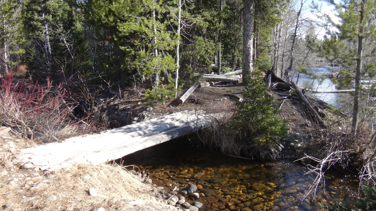
One of the bridges you will cross by Cottonwood Creek

Trail by Cottonwood Creek

Lucas Homestead - far right. Trail on left.

Do not head for the homestead.

Meadows with Lucas Monument.
 View of the Grand on the approach in June
That big rock contains the ashes of Geraldine Lucas, the 2nd woman to climb the Grand. The Lucas
Monument is on an obvious boulder in the middle of the meadow. The trail takes you
right to it.
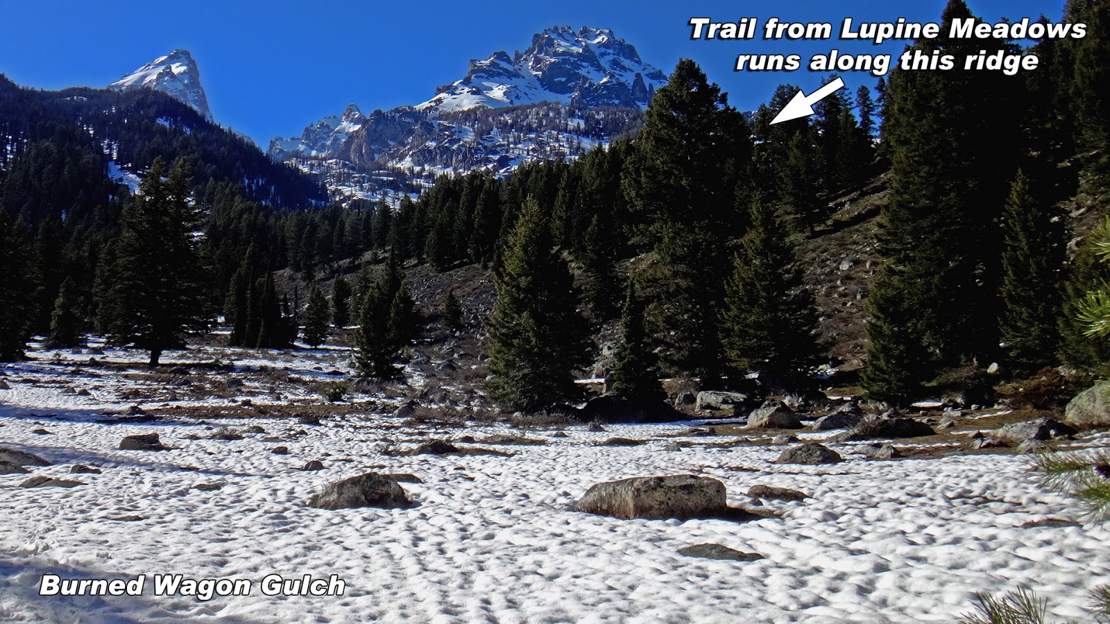
Head for the right side of the gulch (north side). The trail runs up the south-facing slope.
To get around the swampy area early in the season, it is often best to head north to go around it. Head back to the gulch and find the trail near the NE corner of the gulch. The trail immediately leaves the valley floor and starts up the north side of the gulch.
To get around the swampy area early in the season, it is often best to head north to go around it. Head back to the gulch and find the trail near the NE corner of the gulch. The trail immediately leaves the valley floor and starts up the north side of the gulch.


Lucas Monument next to the trail.


Just inside the gulch and just west of the open meadows

Looking back at the meadows. The Lucas Monument is center-right.

The trail inside the gulch stays on the northern slope (south-facing aspect) for much of the ascent. It goes off the slope as you enter a meadow and then back up the slope as you approach the Valley Trail. You'll hike up the NW "corner" of the gulch to reach the Valley Trail Junction. Just follow the trail.
Perhaps June.

The trail parallels the trail from Lupine Meadows once you are further inside the gulch.


Looking back down at the Valley Trail Junction
The BWG trail IS NOT MARKED.
If you're headed for the Grand, then you're headed for Garnet Canyon, not Bradley and Taggart Lakes. Follow the signs for Garnet Canyon.

Looking up the Valley Trail Junction
Further up the Garnet Canyon trail is another junction for Surprise Lake, etc. You'll head south at that point and follow the trail into Garnet Canyon. Don't go to Surprise Lake.
In the picture above, there was a black bear a few feet off the trail and several deer next to the trail. The bear, the deer, and the human just went about their business like none were around.
In the picture above, there was a black bear a few feet off the trail and several deer next to the trail. The bear, the deer, and the human just went about their business like none were around.
Alternative Route to reach the BWG trail
You can park at the Teton Glacier Pullout along the Teton Park Road or drive north past the turnout to a small dirt parking area on the west side of the road. It's next to the bike pathway. From there, a dirt trial leads to the Lucas Homestead. You'll cross a footbridge over Cottonwood Creek and soon see the Lucas Homestead. We don't recommend this route. It's an option if you want to explore the Lucas Homestead. There is no marked hiker's trail from the homestead to the gulch but you can start hiking toward the gulch and gain the trail.

Do not block the Service Road gate. The parking area isn't for long-term parking, only use it for day trips.

This pathway takes you to the Lucas Homestead.

Bridge over Cottonwood Creek
Follow the trail to the homestead and then hike toward the gulch just west of the homestead to reach the BWG trail.
A few trip reports for April through October
July 17th, 2016 (UXM) PNG Variation
Enjoy Safe Climbing