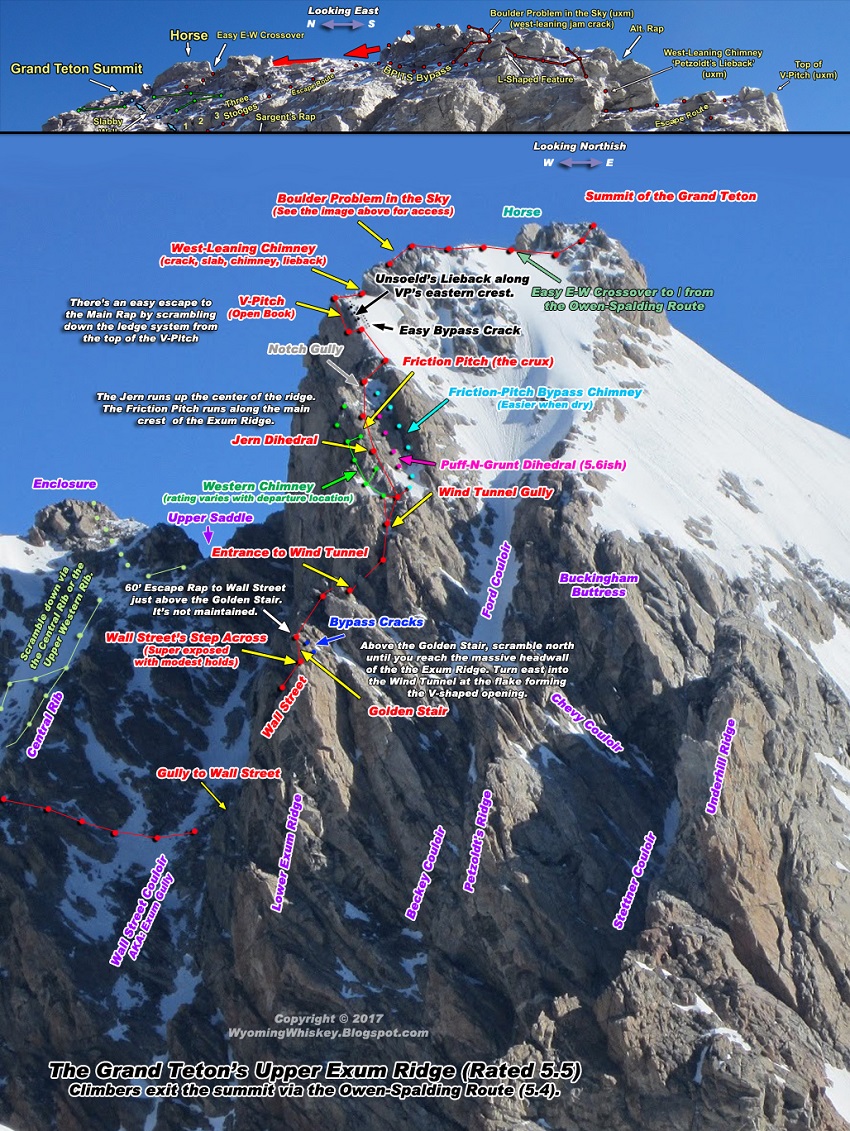
Upper Exum Route
Owen-Spalding on way down
August 10th and an update for August 17th & 24th.
 One last pretty picture.

 Weather Forecast for Wed. August 20th through Sunday the 24th.

FINAL UPDATE Sunday the 24th:
Sunday afternoon was a beautiful day for climbing but rain arrived in the evening. It was calm, temperatures were cool and there was no precipitation. We left Lupine Meadows around 7 a.m. There was more snow than ice on the OS route but there's plenty of ice. The conditions will slow you down. Crampons were taken but not used. An ice axe was also taken but not used - it's good for cleaning holds. Snow is covering ice in many spots and that sometimes makes it easier to traverse the ice. As the snow melts, more ice may form overnight. Early morning climbers will probably want crampons or shoe cleats. The snow is slippery as the day warms up. It's not a very safe place but it can be soloed by climbers familiar with the Grand and who are comfortable soloing with mixed conditions. Of course, conditions are constantly changing.
No climbers were camping Sunday evening at the Lower Saddle, the Moraines, or Petzoldt's Caves. It was a pretty quiet place. Some climbers were at the Meadows in Garnet Canyon. Exum packed up and left for the day. Exum had clients on the mountain but they bailed or went to the Enclosure.
UPDATE Aug. 20th:
Expect dangerous conditions over the next week. Heavy rains soaked the Teton Range on Thursday and snow fell at higher elevations. Snow will fall on Friday and Saturday. Thick ice is possible on all climbing routes. Rockfall will become a greater hazard. The temperatures will get back to normal by Thursday, the 28th - upper 70's. The mountain is slow to drain so low overnight temperatures will form new patches of ice. Weather Story in JH N&G.
Expect dangerous conditions over the next week. Heavy rains soaked the Teton Range on Thursday and snow fell at higher elevations. Snow will fall on Friday and Saturday. Thick ice is possible on all climbing routes. Rockfall will become a greater hazard. The temperatures will get back to normal by Thursday, the 28th - upper 70's. The mountain is slow to drain so low overnight temperatures will form new patches of ice. Weather Story in JH N&G.
FORECASTS FOR SELECT LOCATIONS 20th - 22nd:
               WED|   WED|   THU|   THU|   FRI|
                  | NIGHT|      | NIGHT|      |
---------------------------------------------------------------------
LOWER SADDLE            43|    39|    41|    36|    40| TEMP(F)
  11600 FT              W 13| SW 18| SW 18| SW 17| SW 16| WIND(MPH)
                         60%|   70%|   80%|   70%|   60%| PRECIP(%)
---------------------------------------------------------------------
GRAND TETON SUMMIT      35|    31|    33|    28|    32| TEMP(F)
  13775 FT              W 13| SW 18| SW 19| SW 17| SW 17| WIND(MPH)
                         70%|   70%|   80%|   70%|   70%| PRECIP(%)
---------------------------------------------------------------------
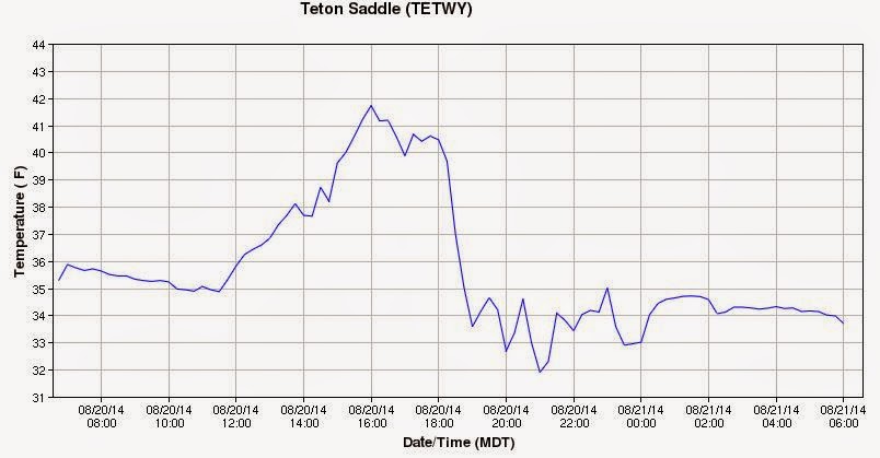
How accurate is the NWS Recreational Forecast for Select Locations? The graph below shows the actual temperature readings from the Lower Saddle's weather station for Wednesday the 20th and early Thursday morning the 21st. The forecast low for Wednesday night was 39. The actual low was 32. That's a difference of 7 degrees.
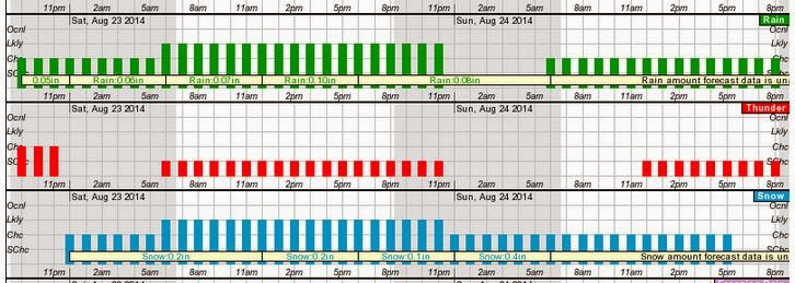
Wednesday's Hourly Forecast for the Weekend: 23rd & 24th. SNOW
UPDATE Aug 17th:
New ice was on the Owen-Spalding route. Most of it was in the Owen Chimney. It's not like September ice that really slows you down but it demands your attention. The Catwalk had ice on the eastern wall and small patches on the ledge below. Minor patches were in the Double Chimney & Sargent's Chimney. In deeper recesses of Sargent's, you'll usually find thick patches of ice all year long. Running water continues to flow in many drainage areas. We didn't leave Lupine Meadows until after 10:30 a.m. so it's hard to say if ice was at lower elevations in the morning. Other climbers said the summit was windy and very cold in the early hours. It was comfortably warm and fairly calm when we arrived.
The water temperature in Jenny Lake was just below 60° mid-morning and just above 60° at 6 p.m on Sunday. Both readings were taken in the shade in 3 ft of water near the shore. At 6 p.m., the temperature in Jackson was 79°. Yesterday's high was 81° and the low was 43° according to the NWS data.
If you're planning a visit over Labor Day, expect large crowds in Jackson and a busy mountain if the weather is nice. A free Lynyrd Skynyrd concert is planned for Jackson's 100th birthday.
.JPG)
.JPG)
.JPG)
UPDATE Aug 14th:
Jupiter and Venus will be seen close together in the sky between the 17th and 18th on the northeastern horizon near 75° early in the morning. The two planets will be separated by 0.2 degrees, roughly 40 percent the diameter of a full Moon. The time they become visible will depend upon your location - valley or mountain top. Climbers on the Grand may see the planets just before dawn.

Jupiter and Venus will be seen close together in the sky between the 17th and 18th on the northeastern horizon near 75° early in the morning. The two planets will be separated by 0.2 degrees, roughly 40 percent the diameter of a full Moon. The time they become visible will depend upon your location - valley or mountain top. Climbers on the Grand may see the planets just before dawn.

FORECASTS FOR SELECT LOCATIONS - Thursday Aug 14th - Saturday Aug 16th:
                       THU|   THU|   FRI|   FRI|   SAT|
                          | NIGHT|      | NIGHT|      |
---------------------------------------------------------------------
LOWER SADDLE            45|    42|    49|    40|    49| TEMP(F)
11600 FT              W  7|  W 11|  W 15|  W 11|  W 16| WIND(MPH)
                       60%|   60%|   30%|   20%|   10%| PRECIP(%)
---------------------------------------------------------------------
GRAND TETON SUMMIT      37|    34|    41|    32|    41| TEMP(F)
13775 FT              W  7| SW 12|  W 15|  W 12| SW 16| WIND(MPH)
                       60%|   60%|   30%|   20%|   10%| PRECIP(%)
---------------------------------------------------------------------
THIS PRODUCT IS ISSUED AROUND 3 AM DAILY. FOR THE MOST UP-TO-DATE
INFORMATION CALL 1-800-211-1448 OR VISIT WWW.WEATHER.GOV/RIVERTON

5-day Forecast Thursday August 14th - Monday Aug. 18th.
Trip Report: August 10th:
Moisture and low overnight temperatures from earlier in the week contributed to minor icy conditions on the Owen-Spalding route - specifically on the Catwalk & in the Owen Chimney. Wet rock was found in many drainages. The Upper Exum was mostly dry. Small patches of ice were in the nooks of the chimney variations like the Friction-Pitch Bypass and the Western Chimney.
It was another crowded day at the Lupine Meadows parking lot. It was also very warm. Most of the thin layers of new ice should burn off quickly. The mountain is slow to drain and low overnight temps will refreeze what's flowing during the day.
It was another crowded day at the Lupine Meadows parking lot. It was also very warm. Most of the thin layers of new ice should burn off quickly. The mountain is slow to drain and low overnight temps will refreeze what's flowing during the day.
Climbing Rescue Friday August 8th:
.JPG)
.JPG)
.JPG)
Last week's rain storms and below-freezing overnight temperatures on the summit block did create new patches of ice. Recent freeze & thaw cycles do increase the chances of rockfall. The area between the Friction Pitch and the V-Pitch is one of the easier sections to navigate during this time of year. It's a mix of walking, low-grade climbing, and scrambling. It seems very unlikely that Mr. Markusen had trouble with the terrain. Perhaps Mr. Markusen will remember things more clearly after he recovers. For all anyone knows, he slipped on ice, or had a stroke.
The News & Guide story said the Mr. Markusen was free-soloing and that he had climbed the Grand perhaps "20 times". Initial reports said he was not wearing a helmet. Mr. Markusen arrived at St. John's Medical Center about five hours after the accident. If it wasn't for parting clouds that allowed a helicopter to move into place for a short-haul rescue, it could have been many more hours before Mr. Markusen reached a critical care center.
The good news is that "there’s no rule against" climbing alone according to Grand Teton National Park spokeswoman Jackie Skaggs. And, Mr. Markusen seems to be doing well.
The founder and managing director of Northern Natural Resources, Minneapolis businessman Steve Markusen, 60, was found injured by two climbers at about 11 a.m. on Friday, August 8th. He was between the Friction Pitch and V-Pitch on the Upper Exum route. According to Grand Teton National Park spokeswoman Jackie Skaggs, “He didn’t know what had happened.” Rangers concluded that Markusen had fallen about 50 feet after tumbling over granite slabs and loose rock. He suffered “extensive, dramatic injuries.” As is typical of news releases from the Grand Teton National Park, the location details are hard to come by and the story line may change as days pass. GTNP News Release.
Looking down the slope from just below the V-Pitch.
Looking up the slope from just above the Notch.
Mr. Markusen could have been at the slabby area above the Notch and below the V-Pitch. If so, he may have tumbled into the gully that runs between the Friction Pitch and the Notch, or he may have tumbled toward the Ford Couloir. The slabby area is not known for rockfall unless other climbers cause it. The wind can block many sounds but tumbling rocks are pretty hard to muffle. If he was injured in the gully below the Notch, then he could have been hit from above with little warning depending upon his location.
The gully above the Friction Pitch.
The V-Pitch is at the very top of the photo - off center to the left.
The News & Guide story said the Mr. Markusen was free-soloing and that he had climbed the Grand perhaps "20 times". Initial reports said he was not wearing a helmet. Mr. Markusen arrived at St. John's Medical Center about five hours after the accident. If it wasn't for parting clouds that allowed a helicopter to move into place for a short-haul rescue, it could have been many more hours before Mr. Markusen reached a critical care center.
The good news is that "there’s no rule against" climbing alone according to Grand Teton National Park spokeswoman Jackie Skaggs. And, Mr. Markusen seems to be doing well.
August 10th Trip Report Photos
Click to see a larger size.


.JPG)
Lupine Meadows Trailhead

.JPG)
Snow covers a patch of the Climbers' Trail
.JPG)
Sign at the Meadows Camping Zone in Garnet Canyon
.JPG)
Garnet Creek
.JPG)
Flower near the Meadows in Garnet Canyon
.JPG)
.JPG)
.JPG)
View down toward the Meadows Camping Zone.
.JPG)
.JPG)
.JPG)
The spring that feeds Spalding Falls - next to sign for the Petzoldt's caves Camping Zone.
.JPG)
.JPG)
.JPG)
.JPG)
Petzoldt's Caves Camping Zone - PCCZ.
.JPG)
View back down toward the Meadows' Camping Zone from the switchbacks by Spalding Falls.
.JPG)
.JPG)
.JPG)
Switchbacks above Spalding Falls / PCCZ.
.JPG)
.JPG)
Climber at the cliff where another climber died last year. This is next to the PCCZ.
.JPG)
PCCZ.with the Meadows in the background.
.JPG)
S. Fork Garnet
.JPG)
Snow covers some of the route to Middle Teton from the Meadows - South Fork.
.JPG)
PCCZ by clump of trees
.JPG)
Red stripe in rock
.JPG)
Switchbacks above Spalding Falls / PCCZ.
.JPG)
Switchbacks above Spalding Falls / PCCZ.
.JPG)
Clump of trees to right is by PCCZ.
.JPG)
Switchbacks above Spalding Falls / PCCZ.

Flowers by the first drainage above Spalding Falls
.JPG)
This 1st drainage can dry up during the climbing season. A second drainage further up the trail runs all summer.
.JPG)
Corbets High Camp - JHMG

Moraines Camping Zone

The 2nd Boulder Field
The trail restarts by the sign near the most-eastern camping location at the start of the Morainal Camping Zone.
The trail restarts by the sign near the most-eastern camping location at the start of the Morainal Camping Zone.
.JPG)
Lower Saddle's headwall & Middle Teton Glacier
.JPG)
Camping Spot at the MCZ
.JPG)
Moraines
.JPG)
Fixed Rope
.JPG)
View toward the toe of the Middle Teton from the Fixed Rope.
.JPG)
Fixed Rope.
.JPG)
MCZ - Middle Teton Glacier
.JPG)
Lower Saddle
.JPG)
Sign by most eastern camping spot and near the water hose in a small drainage to the SE.
.JPG)
LSCZ


.JPG)
Wall Street
.JPG)
View from WS toward Crossovers on the Central Rib
.JPG)
Wall Street shelf
.JPG)
Golden Stair
.JPG)
Cracks Variation to NE of GS.
.JPG)
Little 'Boulder' Problem above GS.
.JPG)
Lower Saddle
.JPG)
Wind Tunnel Gully
.JPG)
Wind Tunnel Gully
Jern Dihedral is at center top. Friction Pitch above there.
Jern Dihedral is at center top. Friction Pitch above there.
.JPG)
Jern Dihedral top left of center.
F-P Bypass Chimney far right.
Puff-N-Grunt opposite FPBC.
Western Chimney unseen to far left.
Friction Pitch at VERY TOP CENTER

Puff-N-Grunt opposite FPBC.
Western Chimney unseen to far left.
Friction Pitch at VERY TOP CENTER

.JPG)
View down entire Friction Pitch and into the Wind Tunnel Gully
.JPG)
The Notch above the FP and Below the V-Pitch
.JPG)
Slabby area above the Notch and below the V-P.
.JPG)
Approach to V-P. Above the Notch.
.JPG)
Approach to V-P
.JPG)
Approach to V-P
.JPG)
V-Pitch
.JPG)
VP
.JPG)
VP
.JPG)
View toward Ford Couloir
.JPG)
BPITS Southern Crack
.JPG)
Summit Ridgeline
.JPG)
Summit Views
.JPG)
.JPG)
.JPG)
.JPG)
Cascade Canyon

.JPG)
Slabby Wall on OS Route.
.JPG)
The center crack in the Slabby Wall points toward the summit and the route down to Sargent's Chimney.
.JPG)
Route back down to Sargent's Chimney
.JPG)
SC rap area.
.JPG)
Lower Sargent's
.JPG)
View to NW from the bottom of Sargent's toward a climber coming out of the Owen Chimney.
.JPG)
Two climbers coming out of the Wittich Crack. They are just below the Catwalk.
.JPG)
The Catwalk with streams of ice.
.JPG)
Northern end of the Catwalk
.JPG)
Owen-Chimney Parallel Bypass Crack
.JPG)
Owen Chimney
.JPG)
Double Chimney
.JPG)
Double Chimney
.JPG)
View toward the Catwak from the exit of the DC
.JPG)
View toward the Catwak from the exit of the DC
.JPG)
Inside the DC. Open "V" on left. Tunnel on right.
.JPG)
Open "V" in DC
.JPG)
Very wet 1st Entrance to DC.
.JPG)
The Crawl
.JPG)
MT from Upper Saddle
.JPG)
Exposed variation along the Upper Saddle's Crest. The 'southern' variation is more common.
.JPG)
Exposed variation - coming off the Upper Saddle's eastern side.

Approach to Upper Saddle
.JPG)
Approach to Upper Saddle
.JPG)
Upper Central Rib far left.
.JPG)
Access to the Black Rock Chimney along the CR. Go through the little 'saddle' opening.
.JPG)
BRC
.JPG)
Climbers seen from the BRC using the Upper Western Rib instead of the BRC.
.JPG)
Climbers above the Briggs Slab
.JPG)
Climber below the Briggs Slab (unseen)
.JPG)
Eye of the Needle above the Chockstone Chimney as seen from the Briggs Slab.
.JPG)
Variations (SOP) to access the CR Bench. Briggs Slab is unseen to the right.
.JPG)
Climbers by the Briggs Slab (unseen). COD on left.
.JPG)
Couloir (drainage) by access to Briggs Slab.
.JPG)
Mini Black Dike.
Follow it to CR's bench then turn south to access Briggs Slab. The slab is at the southern end of the bench. The Mini Black Dike points toward the Central Rib's Upper Crossover to Wall Street.
Follow it to CR's bench then turn south to access Briggs Slab. The slab is at the southern end of the bench. The Mini Black Dike points toward the Central Rib's Upper Crossover to Wall Street.
.JPG)
.JPG)
Looking down at the approach to the Briggs Slab in the OS Couloir (drainage).
.JPG)
Chockstone Chimney far right. Drainage on left. This is at the western edge of the Needle.
.JPG)
LS
.JPG)
Dartmouth Basin
.JPG)
.JPG)
.JPG)
.JPG)
Black Dike and the Needle
.JPG)
LS
.JPG)
.JPG)
Dartmouth Basin
.JPG)
LS
.JPG)
Moraines
.JPG)
2nd Boulder Field
Trail ends at sign (descent) until you pass the 2nd BF. Make a 90 degree turn to the north at the sign and go into the 2nd Boulder Field. The trail restarts after passing the biggest boulder (with the cave under it) just to your east in about 50 ft'.

.JPG)
.JPG)
Garnet Canyon Meadows
.JPG)
.JPG)
Spalding Falls
.JPG)
.JPG)
The Meadows. Spalding Falls. And view toward N. Fork of Garnet.
.JPG)
.JPG)
Garnet Creek

.JPG)
The Meadows and view toward S. Fork of Garnet.
.JPG)
A lone skier just finished a run and is behind some rocks.
.JPG)
Middle Teton
.JPG)
Snow by 1st Boulder Field
.JPG)
.JPG)
Climbers in the 1st Boulder Field. The Platforms Camping Zone is in the trees.
.JPG)
.JPG)
.JPG)
.JPG)
.JPG)
.JPG)
.JPG)
.JPG)
.JPG)
.JPG)
.JPG)
.JPG)
.JPG)
.JPG)


The sun spends less time hitting the OS route
and ice becomes more difficult to burn off.
Lower Saddle Weather Station Data

Lower Saddle Temperature Graph for 8-13-2014. LS Weather Data.
An afternoon storm blew in around 3 p.m. and the temperature dropped about 12 degrees. ven larger temperature swings are possible in 30 minutes.
One of the obvious dangers with storms is the chance for temperatures to drop below freezing on the summit block. It takes more than momentary low temperatures to paint the mountain in ice but it's a threat that is very real as we move into September.

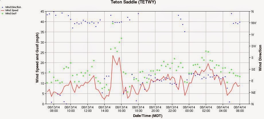
August 13th, 2014.
The wind direction is usually NW at the Lower Saddle.
A storm blew in around 3 p.m.

Gusts over 55 mph are not shown.


~ A Few Trip Reports ~
April Through October
April Through October
July 17th, 2016 (UXM) PNG Variation
Overview - Upper ExumOverview - Owen-Spalding
Enjoy Safe Climbing