The Owen-Spalding Climb
~ Lower Saddle to Summit ~
This is the quickest, safest, and easiest climb on the Grand Teton when the route is dry and the weather is perfect. Under those conditions it is a suitable objective for many athletes who wish to climb this mountain without a rope in a single day. Previous climbing experience is not a prerequisite before undertaking this adventure but it isn't for everybody. It demands agility, finesse and constant vigilance.
The Jenny Lake Climbing Rangers believe that "climbers should not attempt a one-day ascent of the Grand Teton without prior experience on this LARGE mountain and familiarity with technical ascents in the Teton Range" and they warn that "soloists have been injured or killed attempting these routes."
.jpg)
The second party to summit the Grand Teton (2nd verified party) had no knowledge of the area, no similar climbing experience, and no gear. They free-soloed the Owen-Spalding route in a single day back when there was no climbers' trail, no guidebook, and no internet. Quin Blackburn, Dave DeLap, and Andy DePirro did that in 1923. It stands to reason that more than a few people can follow in their footsteps with the resources available today. Indeed, many do. As Renny Jackson says in his Guide to the Teton Range, soloing in a day is "commonplace during the summer when the route is dry".

Free-soloing this route under mixed conditions is not recommended for most climbers. The difficulty & danger increases as does the time needed
to get up and down the mountain. Of course, a little bit of snow, ice, or wet
rock is pretty common. Some climbers can recognize and manage
those hazards. Taking on the additional challenge to free-solo under passable mixed
conditions is a decision best left for yourself. Professional guides
have misjudged hazards and died on this mountain so don't make the
decision lightly.
We don't want to understate or overstate the challenges and risks associated with soloing the Grand Teton. It's obvious that alpine climbing has inherent risk with or without a rope. Some of it can be mitigated; and some, not so much. Additionally, while not everyone can get up this mountain, it has been climbed by blind people, 6-year-olds, 80-year-olds, people missing an arm or leg, an adult with Down syndrome, and out-of-shape flatlanders with no climbing experience whatsoever. Most are guided by friends or the park's climbing concessionaires. And most of the referenced people should never free solo.
It's impossible for us to know how difficult the climb will be for you, how well you will manage the hazards, or how elastic your comfort zone will be. And nothing we say can convey the experience quite like being there in person. YouTube, of course, has thousands of videos of people actually climbing the route.
It's impossible for us to know how difficult the climb will be for you, how well you will manage the hazards, or how elastic your comfort zone will be. And nothing we say can convey the experience quite like being there in person. YouTube, of course, has thousands of videos of people actually climbing the route.

Geraldine Lucas
In 1924, a 58-year-old Geraldine Lucas became the second woman to reach the summit, and first local woman to do so. It was an unexpected accomplishment. Only six visits to the summit had taken place before her arrival. The men standing next to her are Ike Powell, Allen Budge and Jack Crawford. Allen said of the experience, "I never lost anything up there and... never wanted to go back". And trust us, many still feel the same way. For some reason, Allen is missing from the August summit register.
16-year-old Paul Petzoldt, everyone's guide, is sitting in the photo. Paul, with little to no climbing experience, made his first ascent up an icy Grand Teton while wearing cowboy boots. Twenty-two days later, he made his third trip with Geraldine. Paul founded what became Exum Mountain Guides, the National Outdoor Leadership School and the Wilderness Education Association. NOLS alumni went on to run and own Jackson Hole Mountain Guides which was started by Barry Corbet.
Obviously, there is nothing wrong with camping overnight or using protection. Many climbers make it a one-day trip using protection. And you can certainly hire a guide if you have the money. No matter the itinerary, it's a demanding undertaking and a long day for most climbers. Not all athletes can get up and down this mountain, and not all non-athletes are excluded from joining the ranks of those who can.
If you're looking for bubble-wrapped adventures, visit Six Flags Magic Mountain.

There's less than 300 feet of climbing that might test
your natural abilities. Some of that climbing goes by a
large drop-off. It causes more than a few people to reconsider their plans. The Owen-Spalding is considered to be a Class 5.4 climb on the YDS scale of difficulty when dry, "Suitable for beginners".
The latest edition of "A Climber's Guide to the Teton Range" has the class rating at 5.5 for the Double Chimney section. Maybe it's a typo: the guidebook has the entire route at 5.4. Mountain Project also has the Owen-Spalding route at 5.4. That seems about right when it's dry but ratings are pretty subjective. Everyone experiences a climb differently.
For the record, people often shorten the name of the Owen-Spalding route to the "OS", saying the "O" "S" route when speaking.
~~~~~~~~~~~~~~~~
Current Conditions
The Jenny Lake Climbing Rangers occasionally provide reports on conditions through their Teton climbing blog. The park service has two climbing concessionaires on the Grand Teton every day during the summer but it rarely utilizes those resources for more timely updates on conditions. Experienced alpine climbers may find the rangers' reports on mixed conditions too generalized. Additional information on conditions is usually available
through various social media platforms but they can be misleading or outright incorrect. We encourage climbers who are concerned about conditions to do
themselves a favor and keep an eye on the weather leading up to a climb.
Many weather stations on both sides of the Tetons track precipitation and temperatures. Another weather station map.
Summer conditions & information: 307-739-3343
Winter/Off-Season conditions & information: 307-739-3309
Quite often, it can be very difficult to contact the Jenny Lake Ranger Station over the phone. If you're in the park, you can stop by their log cabin
during the summer for details about routes, conditions, challenges, and
to obtain camping permits. The ranger station is open 8am to 5pm daily
from early June to early September. The operating dates change yearly. The rangers also have a hut at the Grand Teton's Lower Saddle during the summer. You might see them there or out climbing.
Local beta about conditions might be found at the AAC's Climber's Ranch in GTNP, the locally-owned Teton Mountaineering shop, the Lupine Meadows trailhead, the Teton County recreation center's new climbing gym, or from the Teton Climbers’ Coalition. The local Black Diamond store is sometimes staffed by local climbers or the REI store (less likely). Hundreds of climbers live in the valley. If you live here, ask around.
The route might clean up quickly after a storm. More likely in July than September but it depends on the weather. Just because no precipitation falls, doesn't mean icy conditions haven't hit the mountain. All you need is cold moist air. Hoar frost occurs when water vapor directly crystalizes on surfaces (deposition). Rime ice can be created when a cloud of supercooled water droplets are freezing on contact with a sub-freezing surface. This can happen quickly. Supercooled water droplets can be found in many stratus and cumulus clouds. Obviously, wet rock is a safety hazard. It doesn't need to be icy.
Conditions in June are always mixed. You'll find icy-snow above 9000 feet. And plenty of new ice being created, or old ice being exposed, on the Owen-Spalding route as we run through June's freeze and thaw cycles. Those snow conditions are changing throughout the day. Bulletproof snow might resemble a 7-Eleven Slurpee once the sun cooks it. At times, June's conditions can be more hazardous than April's. Crampons and an ice axe are often used throughout June.
Of course, many climbers only care about conditions so as to bring the
appropriate gear. It's alpine mountaineering and this mountain gets
climbed year-round. And soloed year-round. Some of the best days in the mountains are the ones with challenging conditions.
The route might clean up quickly after a storm. More likely in July than September but it depends on the weather. Just because no precipitation falls, doesn't mean icy conditions haven't hit the mountain. All you need is cold moist air. Hoar frost occurs when water vapor directly crystalizes on surfaces (deposition). Rime ice can be created when a cloud of supercooled water droplets are freezing on contact with a sub-freezing surface. This can happen quickly. Supercooled water droplets can be found in many stratus and cumulus clouds. Obviously, wet rock is a safety hazard. It doesn't need to be icy.
Conditions in June are always mixed. You'll find icy-snow above 9000 feet. And plenty of new ice being created, or old ice being exposed, on the Owen-Spalding route as we run through June's freeze and thaw cycles. Those snow conditions are changing throughout the day. Bulletproof snow might resemble a 7-Eleven Slurpee once the sun cooks it. At times, June's conditions can be more hazardous than April's. Crampons and an ice axe are often used throughout June.
Conditions in September aren't as predictable as June's. The odds increasingly favor mixed conditions and
colder weather with each passing day but every year is different. If precipitation falls, it will usually fall as snow or graupel
at upper elevations on the majority of September evenings. Of course,
it can also snow during the day. Icy conditions may start to appear on the approach. Every once in a blue moon we have the rare September (or even October) with above-average temperatures and passable conditions for numerous fast & light round-trips.
Safest Time For Free-Soloing
The best days for free-soloing under dry conditions usually arrive between mid-July and mid-to-late August. Every year is different. New snow or ice can cover the mountain at any time but poor conditions in July and August tend to clean up pretty quickly.
The best time of day to climb depends on the weather. An early start is recommended to avoid the possibility of afternoon thunderstorms which are often omitted from a morning forecast. Highly localized afternoon thunderstorms may pass by quickly. They are more likely after 3 pm but most climbers aim to get off the mountain way before then if there is any instability in the atmosphere. You might want to reconsider your plans if the forecast discussion mentions monsoon moisture or a cold front.
Many guides leave the Lower Saddle at 4 a.m. This is done for several reasons like avoiding crowds and incoming weather. Soloing parties who are moving quickly might leave the trailhead at daybreak, or later if the forecast is nice. Many climbers who are hauling gear on a one-day round-trip start between midnight and 2 a.m.
June is never the safest time to solo the mountain. Rockfall hazards increase with June's freeze & thaw cycles. Flushing in couloirs is common. Snow slides down faces. Water undercuts the snowpack. Moats and voids open up. It's a mess. The steeper wind-blown faces and ridgelines might be easier to manage than the approach in June or early July, especially south-facing aspects such as the Exum Ridge. The classic ski mountaineering film Fall Line shows some typical Teton conditions in June.
Fall Line from Bob Carmichael
Weather
LOWER SADDLE
*** NWS Extended Lower Saddle Forecast 11,600'
*** NWS Hourly Lower Saddle Forecast 11,600'
NWS Forecast Discussion (West & Central WY)
Lower Saddle Weather Station 11,600' (Summer Only)
JXN/GTNP
NWS Forecast: GTNP / JXN
Sun, Moon, Planet Times in JXN
Current Weather, Air Quality & Visibility GTNP
Grand Teton Webcams
A
forecast is good for about 6 hours. Even within 6 hours, it's of questionable value for the Tetons. No one can tell you with certainty what's going to happen within a ten mile radius of the Grand Teton unless there's a big, stable, high-pressure system parked over the region and we're in its center. Or there's a massive storm system slamming the Northern Rockies. As anyone who climbs in the Tetons knows, a forecast with an 100%
chance of precipitation might be 100% wrong. Basically, never trust a forecast. Dig a little deeper and be prepared
to read the weather as you travel.
To point out how easy it is to trip up professional forecasters, Jackson's local meteorologist Jim Woodmencey—also a former GTNP climbing ranger and owner/operator of mountainweather.com—was unable to accurately forecast the weather for the big solar eclipse that crossed the valley. It was a beautiful sunny day—except for totality.
To point out how easy it is to trip up professional forecasters, Jackson's local meteorologist Jim Woodmencey—also a former GTNP climbing ranger and owner/operator of mountainweather.com—was unable to accurately forecast the weather for the big solar eclipse that crossed the valley. It was a beautiful sunny day—except for totality.
To be clear: if there is the slightest instability in the forecast, then the forecast is saying "ANYTHING could happen in the mountains". Highly localized mountain thunderstorms can develop quickly and unexpectedly. A tiny change in the jet stream can sideswipe the Tetons with cold, wet weather. Warm sunshine can blanket the town of Jackson while the Grand is hammered by snow. Or vice-versa.

Average Weather At The Valley Floor
In the graphic above, it indicates that the average September experiences 16 days below freezing at the valley floor. And the average low temperature is 32 degrees. In the graphic below for the 11,600 foot Lower Saddle, it looks like only 6 or 7 days dipped below freezing in September of 2018.

If it's 90°F in the afternoon at the valley floor, the summit will probably reach the high 50s or low 60s at some point. Cooler in shaded areas. Temperatures above 90°F are pretty rare in Grand Teton National Park.
In 2022, the highest two temperature readings at the Grand Teton's Lower Saddle arrived on September 4 & 8, (63°F & 62°F). And fairly good conditions for soloing quickly were found into October. In 2022, we had one of the driest Julys on record but August rushed in with one of the wettest starts in history. In 2015, it was hard to find a summer raindrop that impacted climbers — except for one notable storm which encased the mountain in snow and ice in August. In July of 1993, 6 feet of snow fell at the Lower Saddle and it was the coldest & wettest summer on record. Great for the retreating glaciers, not so much for climbers. All this illustrates that the weather and conditions can vary greatly from year to year, at any time of year, and averages mean little for any particular summer climbing season.
FYI: It is not unusual to find water sources frozen at the saddle even though the weather station's thermometer says temperatures never got below freezing. If the thermometer isn't broken, we usually assume the thermometer is miscalibrated but unique environmental factors can create the frozen water. It might be something as simple as warmer air passing by the 2 meter high weather station at the western edge of the saddle while cooler air is trapped closer to the ground when the water is. Got us.

Lower Saddle Wind - 107 mph in October, 2018
Forecast wind speed for the Lower Saddle are often off by a factor of two or more due to the topography.

Temperature swings at the Lower Saddle are fairly mild compared to those at the valley floor during the summer. Temperature inversions during the summer are typically limited to overnight or early-morning hours. Summer inversions rarely have large temperature spreads. During the winter, inversions are common and can reach a 40°F difference on extreme days.

If temps are getting cooler with elevation, we consider 12°F to be the worst-case temperature difference between the Lower Saddle and the summit under clear, dry skies (ignoring wind chill). The accuracy of the Lower Saddle's thermometer is not known (nor is an exact lapse rate), so we give ourselves some wiggle room on the worst-case scenario. An average of 8°F was the difference used by the National Weather Service back when they provided a forecast for both the saddle and the summit. That never changed even if the weather did. We have recorded a 12°F difference on a clear morning.
Wildfires
You're more likely to encounter wildfire smoke as we enter August. In 2021, wildfire smoke arrived in the Tetons by mid-July and stayed around all summer. In 2022, smoke wasn't much of an issue. You can track wildfire smoke on most satellite images. Here's a look at Active Fires & Smoke Plumes. Forecast models for smoke are available from many sources including the National Weather Service's Air Quality interface and NOAA's HRRR Smoke Map. Or get a forecast for the jet stream. It is very rare to have a
smoke-free summer in the Tetons.
Emergency Information
(307) 739-3301 - GTNP Emergency Dispatch
GTNP's Emergency Dispatch Center (Teton Interagency Dispatch Center) is open 24 hours a day during the summer season (usually June 1 - Sept 30). For time-critical, life-threatening emergencies, you might be better off calling the park's dispatch center instead of contacting 911 for search & rescue operations in the park.
Once the summer season dies down, the dispatch center is usually open from 6 a.m. to 10 p.m. You can call them to confirm operating hours during your visit: (307) 739-3301
911 works for texting in Teton County, WY & ID
911 calls & text messages go to the Teton County Sheriff's Office. Calls to the Sheriff's Office get transferred to GTNP if the emergency is within park boundaries during the summer. 911 calls within sight of Idaho might get sent to Teton County, Idaho. They can also receive text messages.
Sometimes a text message will get through to emergency services when a voice call will not. Texting 911 is also advised if your phone's battery has been severely drained. Text messages do not include location coordinates like emergency voice calls so be sure to include location information in any messages (detailed place name or GPS coordinates).
Information needed by the rescue team includes
1) the exact location of the injured party
2) the time of the accident
3) the nature and extent of injuries & medical care being provided
4) equipment at the scene (ropes, hardware, first-aid kit, etc.)
5) the number of people with the injured party
6) the plan of action (if any).
1) the exact location of the injured party
2) the time of the accident
3) the nature and extent of injuries & medical care being provided
4) equipment at the scene (ropes, hardware, first-aid kit, etc.)
5) the number of people with the injured party
6) the plan of action (if any).
The Teton County Backcountry SOS App will drop a GPS location into an emergency text message if your phone's GPS is on. A phone's GPS will consume battery power so turn it off if it isn't needed.
Summer Camping
Summer backcountry camping permits can be reserved online
starting in January. First-come,
first-served, walk-in permits are available during the summer and they are usually in high demand. Backcountry permits involving climbing or mountaineering, and camping in Garnet Canyon must be obtained at the Jenny Lake Ranger Station, when open, mid-June through mid-September. Garnet
Canyon has special regulations for backcountry campers.
For information on free Winter Backcountry Camping Permits call 307-739-3309 M-F or 307-739-3301 Sat & Sun (Park's Dispatch Center). Park visitor centers are closed during the winter. Update: the park service has two different telephone numbers on two different webpages which is not unusual. Call the dispatch center if 3309 doesn't work M-F.
Our Jackson Hole Camping Guide covers some additional camping options if you are unable to secure camping options in the park. Of course, other websites have details about every camping site in the USA and are regularly updated unlike ours. The National Elk Refuge & Greater Yellowstone Visitor Center is also a good resource for visitors.
Additional Details
Just to be clear, let's repeat a few things. Inexperienced mountaineers who wish to summit in a day without using protection are strongly encouraged to wait for the driest conditions possible and perfect weather. Optimal
conditions for free-soloing may not
arrive until late July or early August. Just depends on the weather. Sometimes it's early July.
No one knows how long it will take you to complete a round-trip on the Grand Teton. The fastest round-trip time is under 3 hours. It might take you 24 hours. The round-trip covers around 15 to 16 miles with a 7000 foot elevation gain. Renny Jackson says the Lower Saddle is 7.5 miles from the trailhead in his guidebook. If true, that puts the round-trip to the summit and back closer to 16 miles. The exact distance hasn't been measured with a survey-grade GPS so the actual distance you travel is unknown.
No one knows how long it will take you to complete a round-trip on the Grand Teton. The fastest round-trip time is under 3 hours. It might take you 24 hours. The round-trip covers around 15 to 16 miles with a 7000 foot elevation gain. Renny Jackson says the Lower Saddle is 7.5 miles from the trailhead in his guidebook. If true, that puts the round-trip to the summit and back closer to 16 miles. The exact distance hasn't been measured with a survey-grade GPS so the actual distance you travel is unknown.
There is a short introduction to the approach on this page. Our webpage that covers the approach to the Grand Teton's Lower Saddle goes into greater detail. To be honest, many people making their first ascent just follow other climbers from the trailhead but it's good to have an understanding of the challenges and your intended route. The number of people heading off in wrong directions is amazingly high.
Water

If you arrived at the trailhead without water or filter (or iodine treatment tablets), you can drive to the
South Jenny Lake Store near the Ranger Station and fill up for free at
their outdoor water station during the summer.
Water is found at many places along the trail. The trail crosses the source of spring water feeding Spalding Falls just as you reach the top of the cliff that is part of the Meadows Headwall. You'll be near the Caves Camping Zone. It's a good place to take a break and refill your water supply. Most people drink the water unfiltered. We're guessing it's around 5.25 miles from the trailhead to the spring. We always make sure to have enough water to get there.
Spalding Falls is one of several arteries feeding Garnet Creek. Unfortunately, water quality in the creek has declined with increasing activity in Garnet Canyon. We won't drink the creek's water below the falls during the summer unless its been filtered.
Split Times
Assuming you're trying to go fast & light, and can, it's about a
half hour to 1st junction from the Lupine Meadows' trailhead if you're
walking quickly (not running).
The second junction adds another half hour from the first junction. And
it's another half hour to the Meadows Camping Zone inside Garnet Canyon
if you maintain
speed. That's 1.5 hours in total. From there, it's about an hour to reach the Lower Saddle (2.5 hrs total)
if you're still moving at a good pace. Very few people will be moving quickly.
The average person can take many hours to reach the Lower Saddle from
the trailhead. Most people are not free-soloing, or on a fast & light round-trip.
The fastest runners reach the Grand's summit from the trailhead in under 2 hours. Local athletes regularly reach the summit in under 3.5 hours from the trailhead. In 2017, Ryan Burke, 35, made three 6-hour round-trips of the Grand Teton back-to-back. He actually completed the three summits in 17 hours, 54 minutes. Some settle for two. Meredith Edwards made two back-to-back round-trips up the Grand in about 16 hours just before Ryan's threesome. Plenty of professional mountain runners could easily beat Ryan's time but only Ryan will actually do three round-trips. By the way, very few people who do record-breaking stunts provide any proof of their elapsed time. However, Ryan's time is not in doubt. It sounds just about right.
If you can top out on Snow King Mountain's Exhibition ski run in under 23 minutes (68.3 vertical-ft/min over 0.3 miles), then a sub-5-hour round-trip is looking possible (it is hard to sustain that pace over the 8 or so miles to the Grand's summit). If you can hike from the Jackson Hole Mountain Resort's parking lot to the summit above the tram in under 90 minutes using all the trail shortcuts (46 vertical-feet/min over the 4,139 ft elevation gain), then you shouldn't have a problem nailing a 6 hour round-trip like Ryan while taking a more moderate pace. A runner who competed in JHMR's Hillclimb in 2023, hit 71 vertical-feet/min, taking under 60 minutes to finish the 6.2 mile uphill course. If you're doing that, you'll be closer to a 3-hour-round-trip on the Grand.
The Fastest Two Runners
Andy Anderson, 2h53m02s, August 22, 2012
(1:48:02 up, 1:05:00 down)
(1:48:02 up, 1:05:00 down)
Kilian Jornet, 2h54m01s, August 12, 2012
~ Trailhead to Summit and back ~
Fastest Woman
Emelie Forsberg, 3h51m, August 11, 2012
Jen Day Denton, 4h15m27s, July 9, 2022
Jen also did The Picnic in 10h40m
Jack Kuenzle of Roxbury, Connecticut ran a pretty fast time of 3:02:32 on August 16, 2023. His GPS data is on the Strava website. The overlay of his path on the topo map shows just how difficult it is
to accurately track a course above the Lower Saddle. The GPS has him all over the
place. His round-trip was estimated to be 13.8 miles by his watch. He
took a couple shortcuts. Kilian's GPS data used to be on Suunto's "Movescount" website before the website was discontinued. It might be on their app. He took many shortcuts (some illegal). Stephen Mulherin had a nice fast time of 3:00:34, in 2015. No GPS data. Stephen's old record for the JHMR's Hillclimb was pretty impressive.
~ Others who tried (incomplete list) ~
Rickey Gates, 3:19, 2012
Bryce Thatcher, 3h06m, August 26, 1983
Creighton King, 3:30:39, 1983
Jock Glidden, 4:11, 1972
Joe Hawkes, 5:21, 1939
Rickey Gates, 3:19, 2012
Bryce Thatcher, 3h06m, August 26, 1983
Creighton King, 3:30:39, 1983
Jock Glidden, 4:11, 1972
Joe Hawkes, 5:21, 1939
Glidden & Hawkes might have started from Jenny Lake instead of the Lupine Meadows trailhead.
FWIW: The Fastest Round-Trip Ski Run on the Grand Teton was captured by Jared Inouye, Jason Dorais, and Andy Dorais who came in at 5:17 on June 28, 2011, taking couloirs to the summit.
Exum reported that Rod Newcomb at 75, celebrated his 55th year of climbing the Grand with a one day ascent on July 2nd, 2009. Rod left the Lupine Meadows parking lot at 2:30 a.m. and topped out on the Grand around 11:15 a.m. Possibly record breaking for 75. Rod might have made over 400 trips up the Grand Teton according to Jack Tackle and Bill Anderson.
Supplies
Make sure you have the supplies necessary for a safe trip before venturing to the trailhead. Headlamp with fresh batteries? Water? Toiletries? Proper clothing, especially shoes? Food? Charged phone? First Aid? Helmet? Gloves? Hiking poles? Whatever. On really nice days, everything we need fits in our pockets or a very small pack (fanny size). Fast and light is the objective. Every unnecessary ounce is a burden but we like hiking poles. If you're unsure about your abilities, it's better to play it safe and take some extra supplies for unexpected delays. By the way, a helmet isn't just good for falls, slips and incoming rock, it is also great for keeping golf-ball-sized hail from smashing your noggin.
Free-soloing runners (the select few) carry next to nothing and wear clothing totally unsuitable for most climbers. Runners might also start later and experience very comfortable temperatures. Warmer temperatures will increase hydration needs for the average soloing climber, as will running.
The Approach

All Garnet Canyon Data from GAIA GPS
(best viewed on a desktop/laptop computer)
This GPS data has the distance to the Lower Saddle at under 6.5 miles. About 1 mile less than the guidebook number. Most smart phones and watches won't capture the actual distance because they miss many small twists and turns in the trail especially if someone is moving quickly. And they simply lack the accuracy of professional gear.
While you don't need a GPS to make it up the Grand Teton, it's good to examine a map. We do run into climbers every year who took the wrong turn at a well-marked junction. Pay attention and you'll be fine. Be wary of letting partners run ahead or lag behind (or separate). Almost every year this doesn't work out well for one of the party members.
While you don't need a GPS to make it up the Grand Teton, it's good to examine a map. We do run into climbers every year who took the wrong turn at a well-marked junction. Pay attention and you'll be fine. Be wary of letting partners run ahead or lag behind (or separate). Almost every year this doesn't work out well for one of the party members.

Approach above 9000 feet. And camping locations
You might want a camping permit if you have issues with your knees or can't sustain a long day in the mountains.
The dry summer trail to the Lower Saddle is mostly well defined and easy to navigate. It does completely disappear for over 200 feet at two locations filled with large boulders. They are commonly referred to as the 1st & 2nd Boulder Field, AKA: Platforms Boulder Field & Morainal Boulder Field where the trail disappears. Almost the entirety of Garnet Canyon is a giant boulder & talus field with the trail running through it but some areas are more bouldery than others. The park regularly maintains the original trail to the 1st Boulder Field. Above that, the trail sees only occasional maintenance which is mostly limited to the trail running up to the Petzoldt Caves Camping Zone by Spalding Falls.
The trail disappears in an insignificant way for a short distance in several locations between the 1st Boulder Field and the Meadows Camping Zone. Usually, the trail continues just in front of you. Take the path of least resistance. You are always on the north side of the creek inside Garnet Canyon. And you are close to the creek. You may get off trail but you won't get lost getting to the Meadows.
You may see a few side trails inside Garnet Canyon especially as you near the top of Spalding Falls. Some spurs go to camping spots. Some are shortcuts. Some go to climbing areas. Others are used to avoid early-season snow. The Park Service would like everyone to stay on well-traveled paths whenever possible, or stay on rocky surfaces and not vegetation if you must go off-trail.
Traveling under darkness might be a slightly bigger challenge inside Garnet Canyon if you're not familiar with the approach to the Lower Saddle. People do lose the summer trail so we can't say it's a foolproof approach under darkness.
Traveling under darkness might be a slightly bigger challenge inside Garnet Canyon if you're not familiar with the approach to the Lower Saddle. People do lose the summer trail so we can't say it's a foolproof approach under darkness.

Click to Enlarge

Climbers use a bootpack to gain the top of the Lower Saddle as we enter the summer season, and sometimes well into the summer season. Usually, the fixed rope starts seeing action by mid-July. As always, just depends on the weather. Many people hike directly up and down the headwall when it's easy to do so. While snow travel adds extra hazards it can also speed up round-trips under the right conditions. All the more so if you're on skis (usually springtime).
As the snow melts off, the dry summer trail takes you to a rope that is permanently affixed to the saddle's headwall. The rope drapes over a drainage. It's pretty handy when everything is slick. Scrambling up the headwall without using the rope is common.
The vegetation atop the saddle is fragile. The park asks climbers to stay off of it whenever possible. To the SE of this sign is the saddle's water source (maybe 100 ft away).
.JPG)
When snow covers
the canyon's floor, climbers typically ascend the Meadows' Headwall closer to the Middle Teton's NE aspect. They usually avoid the summer trail by Spalding Falls. Climbers have died on a snowy approach. Respect the snow. You might give yourself a lethal injury with a climbing axe. It has happened. Do not underestimate the threats. More information on snow travel can be found on our page covering the approach.
Parts of the Grand Teton's Lower Saddle can be seen from a few areas as you approach the Meadows Camping Zone but the Lower Saddle mostly hides behind the Meadows' Headwall.


The North Fork of Garnet Canyon
The Morainal Camping Zone runs along the elevated section of rock (the glacier's moraine) at the edge of the Middle Teton Glacier.
June approach @ Moraines
Climbers use a bootpack to gain the top of the Lower Saddle as we enter the summer season, and sometimes well into the summer season. Usually, the fixed rope starts seeing action by mid-July. As always, just depends on the weather. Many people hike directly up and down the headwall when it's easy to do so. While snow travel adds extra hazards it can also speed up round-trips under the right conditions. All the more so if you're on skis (usually springtime).
As the snow melts off, the dry summer trail takes you to a rope that is permanently affixed to the saddle's headwall. The rope drapes over a drainage. It's pretty handy when everything is slick. Scrambling up the headwall without using the rope is common.
Guides belay clients at the fixed rope so you might be slightly delayed. If you struggle in any way with the climbing at the fixed rope then free-soloing is not for you. You can contact the Jenny Lake Climbing Rangers to find out if the approach is free of snow or if the fixed rope is being used.

Upon leaving the fixed rope, climbers follow a path toward the southeast corner of the Lower Saddle. They travel to the toe of the Middle Teton as it sits on the saddle and end up by the most southeastern camping site.

Lower Saddle's Fixed Rope
This is a rockfall zone. Stay alert. Never travel directly above the Fixed Rope to the west or northwest during the summer due to the high probability of causing rockfall on climbers below you. In some locations the rock is too unstable to remain in place no matter how carefully you move. Small landslides have taken place by the fixed rope and natural rockfall has injured climbers at the headwall.
Upon leaving the fixed rope, climbers follow a path toward the southeast corner of the Lower Saddle. They travel to the toe of the Middle Teton as it sits on the saddle and end up by the most southeastern camping site.

The Lower Saddle Sign
The vegetation atop the saddle is fragile. The park asks climbers to stay off of it whenever possible. To the SE of this sign is the saddle's water source (maybe 100 ft away).
.JPG)
Location of the water hose
That water source is at the toe of the Middle Teton's rocky slope and you'll find a section of garden hose in a shallow drainage to direct water into containers from the trickle of water. Just to the north of the hose is a large seepage area. In the above photo, the hose is by the climber in the red shirt.
People drink this water unfiltered (and untreated) all the time; however, sensitive people may want to filter or treat it. There is no guarantee it's always safe to drink. And the hose may become contaminated by unwashed hands. At times, it can need filtering for particulates. BTW: Symptoms of giardiasis normally begin 1 to 2 weeks after becoming infected. It won't happen quickly. Dehydration can happen quickly.
It is possible for the saddle's water source to dry up or freeze over (typically in September). It can spring back to life with the changing weather. It might also be buried under snow but still flowing. You can get water from the Middle Teton Glacier if water disappears at the saddle. Sometimes you can find running water between the Lower and Upper Saddles but don't count on it.
Many climbers are starting to feel the effects of the altitude and exhaustion as they gain the 11,600' Lower Saddle. It's a good place to take a break. Altitude sickness is a common safety hazard for many. Think twice about ignoring it. And be well hydrated.

If you need to piss in the wind, please do so on the western side of the
saddle. The "rest stop" on the western side of the saddle is for privacy. It is not a functioning toilet. You are required to pack out human waste from the saddle using WAG bags, etc. If you ran out of WAG bags, the rangers might have an extra supply in their hut for emergencies.
There is also a gear hanger on the western side of the saddle should you wish to drop some weight. A bear box is available to store food from critters like marmots and pikas. In addition to them, you might see chipmunks, ravens or an invasion of butterflies. It's rare to see bears, foxes, bighorn sheep and mountain goats at the saddle but they have made visits (mountain goats are considered non-native and the park has culled them).

Two huts are assembled at the saddle every season. One hut is utilized by backcountry rangers as mentioned earlier. The other hut is used by Exum Mountain Guides. A third hut—used by the JH Mountain Guides—sits above the trail to the Morainal Camping Zone. Look toward the east face of the Grand Teton by Teepe Pillar to see that hut.
Most people get cellular service at the saddle & above it. It's a good place to check the forecast. Saddle temperatures
can stay in the 50's on the warmest summer nights. On the coldest summer
nights, temperatures dip below freezing and it can snow at the saddle. It has a well-earned reputation
for strong winds, often double the forecast speeds. On a clear, dark night, the sky is spectacular.
You might see a still camera on the eastern edge of the
buttress that rises above the Fixed Rope (to its northeast). It monitors the Middle Teton glacier. The park has installed several thermometers at higher elevations to collect data at glacier sites.
At one time, they installed webcams and promised to
share those images with the public but quickly changed their mind.
There are small caves on the western aspect of the saddle including one next to the "rest stop". Most are north of it. They are not safe locations during thunderstorms. At times, small caves and overhangs can be more dangerous than open areas.
There are small caves on the western aspect of the saddle including one next to the "rest stop". Most are north of it. They are not safe locations during thunderstorms. At times, small caves and overhangs can be more dangerous than open areas.
The Owen-Spalding Climb

Click to Enlarge
Keep in mind that conditions may force you to alter your line of travel into more difficult (or, by comparison, safer/easier) terrain.

The scrambling begins once you enter the
Black Dike. You may see hiking poles by the dike, the fixed rope, or
elsewhere around the Lower Saddle. Leave all hiking poles where you find
them. They are not abandoned, just set aside temporarily. The dike is
made of black diabase which formed from molten material. It's the same type of dike as seen on the Middle Teton and Mt Moran.

Just a quick safety note to non-climbers:
 The main drainage


The man directly below the photographer is on the ledge that
takes you out of the Chockstone Chimney and to the Eye of the Needle (EOTN). Notice the loose rocks. It's one reason to avoid climbing directly up the lower chimney if climbers are above you. The Briggs'
Slab is just to the right of the photographer and unseen.
BTW: The Eye of the Needle's tunnel is a tight fit if you have a big backpack.

We had no crampons or shoe spikes on this day. The slab was too slick so we scrambled down to the Middle Ledge to reach the Eye of the Needle.

 Over or under the BRA

 Area by Mini Black Dike
Again, after scrambling a short distance up the main drainage or along an elevated path, you'll scramble up a small side drainage containing the Mini Black Dike. You can access the Briggs' Slab and other variations from here. The Briggs' Slab is at the south end of the bench's headwall. It sits right above the Chockstone Chimney. On the other side of the slab is the Cracks of Doom variation. The next picture shows the view of the slab from the Chockstone Chimney.

 Approaching the slab
.JPG)
 The scramble to the Upper Saddle begins here
.JPG)
Let's take a moment to look at some less common variations that are near the Briggs' Slab. Conditions on the slab may force you to choose another variation. Or the slab may be busy with guided climbers.
 SOP and COD
.jpg) The high line over the SOP chimney
The high line over the SOP chimney
Back to the route to the Upper Saddle now that we are on the Central Rib's Bench.

The area between the Lower (11,600ft) & Upper Saddles (13,200)
The main drainage sees weekly rockfall events caused by other climbers. Bowling alley is the favored description. Most climbers should stay out of the drainages whenever possible. Crossing them is common, of course. Having said that, mountaineering runners trying to nail down a personal best time or Fastest Known Time will sometimes run up sections of a dry drainage. Of course, bootpacks up drainages are useful when encountering stable winter/spring snow.
Just a quick safety note to non-climbers:
If
you're unfamiliar with climbing etiquette, the appropriate thing to do
if you kick rocks down the mountain, or see rocks falling down the mountain, is to holler 'ROCK'! even if you see
none below you. It's like saying FORE!
when you make an errant golf shot. Your safety and the safety of others
is everyone's responsibility when it comes to falling rock. Better yet, don't cause rockfall (easier said than done, sometimes). It takes real mental & physical effort to be safe on this mountain.
Back to our climb...
As you move past the western aspect of the Central Rib's Needle, you'll come across the Chockstone Chimney on your right. It's at the first opening along the Needle's western aspect. It allows us to access the Central Rib's Bench. The bench usually provides a safer line of travel to the Upper Saddle. Climbers often avoid the drainages due to conditions or rockfall threats.

Many
people are turning around at the first signs of ice in this area. That
may be a wise decision; however, it's always possible that upper
elevations are actually easier to manage (having tacky snow, much less ice, no ice, or plenty of dry rock).

Many variations to gain the Central Rib's Bench
.JPG) This is the Central Rib's "bench" we are trying to access
This is the Central Rib's "bench" we are trying to access
The two most common variations to access the
Central Rib's Bench are:
1) the Eye of the Needle via the Chockstone Chimney variation
2) the Briggs' Slab variation.
The Briggs' Slab is a common
guided variation. The slab is easy to get to and it's easy for guides to
quickly belay clients across the slab. Guides will utilize other
variations when the need arises. Strong climbers can climb directly to
the slab from the chimney instead of taking the longer approach. The
chance of rockfall from those above you is something to consider.
If you're an experienced mountaineer, you can reach the Upper Saddle
without getting into the fine details shared below.
.JPG)
The Briggs' Slab is at the far bottom-right side of the image. It's directly above an upper section of the Chockstone Chimney.
Let's look at the two most common options in greater detail, starting with the chimney...
Let's look at the two most common options in greater detail, starting with the chimney...
Western side of the Needle by the Chockstone Chimney
The
guided climbers in the above image are descending from the Briggs' Slab and
about to pass the Chockstone Chimney. They are staying on a slightly elevated path above the actual
drainage. Staying just above the drainage sometimes provides an extra measure of safety.
Anyone can follow the guides. It's everyone's mountain. They are not in charge of other climbers. People head off in questionable directions all the time and they may end up in locations that are ill-suited for safe and/or efficient travel so don't just follow any climber.
Anyone can follow the guides. It's everyone's mountain. They are not in charge of other climbers. People head off in questionable directions all the time and they may end up in locations that are ill-suited for safe and/or efficient travel so don't just follow any climber.
Take the Chockstone Chimney or go for the Briggs' Slab
You can scramble up the ledge/step/slab system just to the left of the chimney if you wish to avoid the lowest part of the chimney. That's common and faster. Choose any line that looks efficient and safe. We avoid going straight up the chimney with weaker climbers or young kids. If these options look unappealing, just head for the Briggs' Slab.
Let's look back down the chimney.
Looking down at some variations

Another look
BTW: The Eye of the Needle's tunnel is a tight fit if you have a big backpack.
In 2003, two climbers got stuck on the mountain for three days during a snowstorm. On their third day, climber Joe
Hestick broke his hip and several ribs after taking a fall while
descending the Chockstone Chimney.

A look at the exit from the Chockstone Chimney
We had no crampons or shoe spikes on this day. The slab was too slick so we scrambled down to the Middle Ledge to reach the Eye of the Needle.
Climbers going over the Belly-Roll Almost.
Once out of the Eye of the Needle, climbers traverse under or over the Belly-Roll Almost. Both variations work fine.

If you go under the Belly-Roll Almost, you will be looking for a small
foothold that is out of view until you are directly above that foothold. There are
excellent handholds.
While Emelie Forsberg was attempting a woman's fastest known time (FKT) on the Grand Teton, she used the Eye of the Needle variation during her descent and took the Runners' Slab near the bottom of the Chockstone Chimney. It wasn't the shortest way off the bench but they made good time. She was running with Kilian Jornet the day before he ran his FKT on the Grand. Kilian also ran the Grand's round-trip with Anton Krupicka while on another training run. Anton took the
FKT for Wyoming's highest peak,
Gannett, on September 18, 2012: 8h46m32s car-to-car from
Green River Lakes. His time was beaten (barely) in 2020, by
Aaron Robson
of Lander, WY, with a time of
8h 39m 26s.
Emelie & Kilian on her FKT in 2012 (Chockstone Chimney)
Let's look at the access to the Briggs' Slab and variations near it.

Expanded Overview

(Click to Enlarge)

Again, after scrambling a short distance up the main drainage or along an elevated path, you'll scramble up a small side drainage containing the Mini Black Dike. You can access the Briggs' Slab and other variations from here. The Briggs' Slab is at the south end of the bench's headwall. It sits right above the Chockstone Chimney. On the other side of the slab is the Cracks of Doom variation. The next picture shows the view of the slab from the Chockstone Chimney.

Access to Middle Ledge
It's pretty easy to access the Briggs' Slab from the Chockstone Chimney if you want a more direct line to it. Most people use the Eye of the Needle if they climb up the chimney.

The Briggs' Slab is named after Bill Briggs. Guides use a friction
belay over rock to quickly move clients over it. It's a good choice for kids when roped.
.JPG)
The slab
Let's look at the area above the slab...
The drainage running to the ridgeline of the Central Rib is just an
extension of the Chockstone Chimney. Climbers heading for
the Upper Exum Ridge will cross over the ridgeline. Do not follow them. Owen-Spalding climbers are not headed there.
.JPG)
These climbers are getting ready to be belayed over the Briggs' Slab during a descent.

The Cracks of Doom variation is pretty easy but harder than the slab. There are several lines on the face which vary slightly in difficulty.
The Mini Black Dike runs directly to the Sack o' Potatoes chimney. Climbing the chimney at the top of the Mini Black Dike is not the easiest line of attack in the Sack o' Potatoes but it gets the most attention. The easier option is found to the north of the Mini Black Dike along a high line. The line just south of the Mini Black Dike isn't too hard but loose rocks are more of a hazard. Most people who use the SoP's chimney get delayed. A strong climber might find it a good shortcut.
The Mini Black Dike runs directly to the Sack o' Potatoes chimney. Climbing the chimney at the top of the Mini Black Dike is not the easiest line of attack in the Sack o' Potatoes but it gets the most attention. The easier option is found to the north of the Mini Black Dike along a high line. The line just south of the Mini Black Dike isn't too hard but loose rocks are more of a hazard. Most people who use the SoP's chimney get delayed. A strong climber might find it a good shortcut.
Back to the route to the Upper Saddle now that we are on the Central Rib's Bench.
%20-%20Copy.jpg)
The CR's Bench area
It is wise to choose a path that provides
some protection from rockfall. That path can change when other climbers
are above you. Everyone scrambles at a different pace over different types of terrain so it's hard to say what is fastest for any one person.
The drainages by the Upper Western Rib are usually avoided due to conditions, rockfall hazards, or the extra time involved. If it's off-season in September, have at it.
The drainages by the Upper Western Rib are usually avoided due to conditions, rockfall hazards, or the extra time involved. If it's off-season in September, have at it.

It's steeper than it looks from here

Looking back down

You may see scrappy footpaths between here and the Upper Saddle. Some are useful, some not so much.

Central Rib Overview
Click to enlarge
Let's take a look at the Upper Western Rib variation first. We will examine the Black Rock Chimney variations afterward.
The Upper Western Rib Variation

The UWR is a natural line to follow so most climbers choose it. Same with the drainage. You may see climbers heading up the drainage. Most won't be hit by rockfall, and most won't cause rockfall; however, if everyone thinks it's OK to use the drainage, then rockfall events increase. There are many inexperienced and tired climbers on the Grand every single day. They probably aren't thinking about your safety. The guides sometimes refer to the Upper Western Rib as the Mosh Pit.
It's rare to see runners going for the record books but they stand out if they're in a drainage. Move out of any hazard zone.
The next picture was taken near the same location as the last picture.

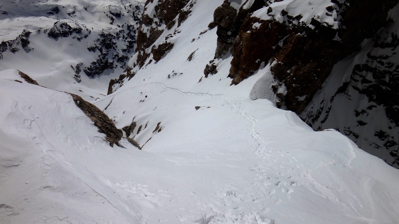
A snowy Owen-Spalding Couloir
Climbers have taken slides to their death due to the tricky snow conditions. On this day, pictured above, we ended up taking a line on the western aspect of the Central Rib, closer to the drainage but above it. The snow was a postholing adventure in the main drainage by the time we started descending. Fine for the ascent.
In June of 1992, a climber lost control near the top of the
Owen-Spalding Couloir. He went over some rock bands and ended up on the
snow about 100 feet above the Black Dike with bilateral wrist fractures,
a right side pneumothorax, and fractures of T-8, T-12 and C4-7 vertebrae. A helmet probably saved his life.

Western aspect of the Central Rib
UWR: Upper Western Rib
EOTN: Eye of the Needle
UWR: Upper Western Rib
EOTN: Eye of the Needle
The photographer is near the location where climbers on the Upper Western Ridge would start to cross the drainage and head back toward the Central Rib.
Jackson Hole Mountain Guide Thomas Raymer was guiding Robert Slater
down the mountain from the Upper Saddle in fresh snow when Slater's
pack caught on a rock and they both fell 200 feet. Slater suffered minor
injuries but Raymer was seriously injured and was carried out the
following day. Raymer had a broken femur & talus, and severe scalp lacerations with part of the skull exposed.

Overview of the upper Central Rib - looking SE.
The marked path is a general direction of travel in the above image.
If you took the Upper Western Rib, head back toward the Central Rib once the slope widens and the Central Rib starts to flatten. You'll end up on the same path as climbers taking the Black Rock Chimney.
If you took the Upper Western Rib, head back toward the Central Rib once the slope widens and the Central Rib starts to flatten. You'll end up on the same path as climbers taking the Black Rock Chimney.
At the top of the Central Rib is the Patio (seen above). It is a
natural flat area where guides often take a
break. The wind tends to blow and the
temps seem to drop as you gain the Upper Saddle
so it's a good place to add an extra layer and grab something to drink or eat.
The Black Rock Chimney Variation
Let's go back down the Central Rib and take a look at the Black Rock Chimney variations.

BRC & Rosenberg Variation (many options)
On June 17, 2013, Grand Teton National Park rangers rescued 57-year-old climbing guide Jim Williams
after the snow that he was standing on near the Black Rock Chimney
collapsed and he took a short fall, catching a crampon on the ice and
sustaining an injury.
There are many loose rocks as you approach the Black Rock Chimney area.

The Black Rock Chimney variation was considered for removal as a guided option by Exum Mountain Guides in 2022, due to too many loose rocks. The Rosenberg Variation tops out at the same location as the chimney. It is usually faster.
You can also wrap around the entire area on an elevated path that stays just above the drainage and then scrambles back toward the Central Rib's crest. That variation runs past (north of) the Rosenberg Variation. This might be the fastest variation for runners who know the way. We haven't timed it. All three options have been guided routes.

Another look at access to the BRC
.jpg)
Once above the Steppy Ramp, you're in the chimney section that runs under the western aspect of the ridgeline. This is very easy scrambling/climbing when dry.

Stay along the western aspect of the Central Rib
If
you're heading for the Steppy Ramp on the descent, go all the way down
the BRC until the ridgeline opens up and you are suddenly on the eastern
aspect of the ridgeline. The Steppy Ramp is right at that
demarcation or transition point. From there, you are forced to take the
eastern aspect of the ridge or the ramp to the west. Take the ramp to
the west.
If you did miss the exit to the Steppy Ramp during the descent and you end up on the eastern aspect, you'll find some slow-moving climbing over some slabs and ledges compared to the ramp. You can regain the Central Rib's Bench further down the rib by using the crossovers that Upper Exum Climbers use. We don't recommend going that way.
If you did miss the exit to the Steppy Ramp during the descent and you end up on the eastern aspect, you'll find some slow-moving climbing over some slabs and ledges compared to the ramp. You can regain the Central Rib's Bench further down the rib by using the crossovers that Upper Exum Climbers use. We don't recommend going that way.
The yellow and green arrows in the above picture are just two travel options right above the ramp. For young kids, the yellow line might be easier to manage. Just depends.

The young child in the green helmet looked to be 6-years-old or younger and rather unhappy with the whole adventure, or too exhausted. And moving at a snail's pace. While very young kids have summited the Grand, most find feeding chipmunks more interesting, fun, and rewarding. Think twice before bringing very young children on this mountain. Same with some adults.

BRC along the western aspect of the Central Rib's ridgeline
This is where the loose rocks are. It's obvious when you're there. Watch your step no matter where you are in this chimney.
.jpg)
These ladies were heading up the mountain to free-solo the Owen-Spalding route.

The bowl-like opening above the BRC and Rosenberg variations- looking SSE
FYI: If you are doing laps on the Upper Exum — and who isn't? — you can take the Wall Street Couloir from the Upper Saddle to reach Wall Street. From an area near the top of the Central Rib, we usually head for the eastern half of the Wall Street Couloir if we choose to go down it. Going up or down the Wall Street Couloir is not recommended for anybody who doesn't need to be there. People do head up and down it by mistake. It is a slope of loose rocks and there are other challenges if you pick the wrong line of descent. Some seldom climbed routes are on the west face of the Exum Ridge directly above the Wall Street Couloir including one of the hardest on the Grand.
In the photo, the top of the Rosenberg is directly below the big white arrow and immediately to your right on a descent.
Do not take the drainage to the Wall Street Couloir shown above. It's not a time-saving shortcut — it's a little funky and has no advantages for free-soloing climbers.
Do not take the drainage to the Wall Street Couloir shown above. It's not a time-saving shortcut — it's a little funky and has no advantages for free-soloing climbers.
FYI: If you are doing laps on the Upper Exum — and who isn't? — you can take the Wall Street Couloir from the Upper Saddle to reach Wall Street. From an area near the top of the Central Rib, we usually head for the eastern half of the Wall Street Couloir if we choose to go down it. Going up or down the Wall Street Couloir is not recommended for anybody who doesn't need to be there. People do head up and down it by mistake. It is a slope of loose rocks and there are other challenges if you pick the wrong line of descent. Some seldom climbed routes are on the west face of the Exum Ridge directly above the Wall Street Couloir including one of the hardest on the Grand.

Another overview of the Central Rib
You may see sloppy & broken footpaths after exiting the top of the bowl. It is best to stay very close to the Central Rib and out of the main drainage.
You may see sloppy & broken footpaths after exiting the top of the bowl. It is best to stay very close to the Central Rib and out of the main drainage.

A view near the Central Rib's Patio
 The Middle Teton
When unconsolidated snow covers foot traps (fall season,
often), the best path to the saddle can be difficult to navigate if you
don't know the area well. Take the time to check your footing.

At
this point, you're above the Middle Teton. Enjoy the views. The Grand
Teton rises about 1000 ft higher than the 12,809' elevation of the
Middle Teton. The Upper Saddle is near 13,200 ft.
Upper Saddle - looking west


Variations to access the eastern side of the Upper Saddle
 Looking back down
.JPG) The southern RED line
The southern RED line
 Another look by the southern RED variation
Loose dirt and rocks are found by the stem move. Move with great care. Mary “Mimi” Conley Bilyeu, an experienced and guided climber fell into the gully directly below the RED route. She did not survive. She most likely slipped on the loose rocks but no one really knows. She was not roped up. Almost no one ropes up here but it's wise to provide a leg up to weaker climbers, spot them, or use a rope.
On this variation, there's a stem move up a rock feature that challenges many climbers. You might find a stepping stone below the stem move to help climbers get over the obstacle.
 The "GREEN" variation
The BLUE route is very useful when conditions make the other options too sketchy (unstable snow, icing, etc), or everything's backed up. It has small holds but it works fine. It might make a novice climber uncomfortable without protection or spotting.
View from above....

.JPG)
A rare 4th variation runs above the red route. It has you climbing along the
seam on the south-facing wall just before the stem move over the flake. We have seen exactly one person use it and only after we suggested it.

Loose dirt and rocks are found by the stem move. Move with great care. Mary “Mimi” Conley Bilyeu, an experienced and guided climber fell into the gully directly below the RED route. She did not survive. She most likely slipped on the loose rocks but no one really knows. She was not roped up. Almost no one ropes up here but it's wise to provide a leg up to weaker climbers, spot them, or use a rope.
On this variation, there's a stem move up a rock feature that challenges many climbers. You might find a stepping stone below the stem move to help climbers get over the obstacle.

The GREEN route sees plenty of descents and ascents. We find that novice climbers would rather climb up it than down it. Kids are better served by a roped ascent/descent of the GREEN line. Many feel it's the easiest ascent line. This is the fastest option. The biggest issue with this line is its exposure to the north and the awkwardness of a descent for novice climbers. Easy to hip belay if needed.
SAFETY REMINDER
Some people get summit fever when they should be bailing. Or making a temporary retreat (depending on the circumstances). If the weather, conditions or skill sets aren't in your favor, it's time to turn around. It's never the wrong call to bail even if you're wrong about the threat. This is especially true if you're responsible for the safety of others. More than a few groups have tried to beat the weather even though they couldn't move quickly; sometimes resulting in injury and death.
Test holds to make sure they'll support your full weight. Look for slip hazards underfoot like verglas and loose rocks. After crossing snow or water, make sure your shoes' soles are dry enough for the slab you're planting your foot on. If a body position or climbing line doesn't feel right, back off and consider another plan of attack.
Take the time to be safe.
"Many of our clients are exhausted and at the limits of their abilities, and they make mistakes. What this means is that our clients are trying to kill each other, they're trying to kill themselves, and they're trying to kill you. Each of us needs to remember this at all times. That's our job." Dave Carman, Exum Mountain Guides, as told in the Outside Magazine story “The House of Rock".
If you're on a guided climb, keep in mind that every climber has a
responsibility to look after their own safety and the safety of
others not only because guides sometimes make incorrect assumptions
about everyone's safety but because that's your job.

Ropes are popular for a reason
Let's get back to our climb
From the Upper Saddle it's less than 600' to the summit. Only a small fraction of that is Class 5.4 climbing when dry. That class rating won't represent the real challenge under heavy icing, especially if you're soloing, more so if soloing without crampons.

The Owen-Spalding Route
Click to Enlarge
Click to Enlarge
AVOID STANDING DIRECTLY BELOW THE RAPPEL AREA
THIS IS A ROCKFALL ZONE
THIS IS A ROCKFALL ZONE


The exposed Belly Roll is at the very NE corner of the Upper Saddle
This area can be windy, freezing, and backed up with climbers. Waiting makes the cold worse. Morning temperatures in the 30s are not uncommon around the Upper Saddle
during the summer. That's before wind chill is calculated. While it's not always freezing and clogged with climbers, you should be prepared for that possibility.
Most free-soloing climbers can safely pass other climbers. It's good etiquette to make sure those climbers are comfortable with the idea, and that those climbers don't put your safety at risk, or vice versa.
People have bailed because they didn't have gloves during the peak summer season. Thin gloves are better than no gloves if it's cold. The climbing rangers have rescued climbers who lost dexterity and grip strength due to low temperatures. Hand warmers can be life savers when temperatures are near or below freezing.

Plenty of climbers turn back at the exposure. We never question that decision nor do we encourage anyone to continue if they make that call. It is a psychological challenge for many.
If you make it this far and decide to bail because of conditions or the challenge then you might want to consider tackling the Enclosure which rises higher than any other peak in the Teton Range other than the Grand. The Enclosure is a western spur off the Upper Saddle and technically not a summit.
To get to the Enclosure, scramble NW from an area closer to the top of the Central Rib. You can't scramble directly to it from the Upper Saddle. The best place to scramble to reach the pseudo-summit is not obvious but it shouldn't take more than 15 minutes when conditions are good.
There is a very small rock formation on the Enclosure's summit in the shape of a circular place for several people to sit. It has outstanding views of the Teton Range. The unusual collection of rectangular rocks were thought to be left by Native Americans. White folks rearranged it into what you see today. It's not known what the original orientation looked like. It's a great place to watch climbers on the western aspect of the Grand Teton. The Enclosure is often the consolation prize that guides dish out when the clients, weather, or conditions make the Owen-Spalding route a questionable proposition. They'll talk it up like it's a treasure of major historical significance atop the second highest high-point in the range to help everyone feel better about not tagging the Grand's summit. That trick might work if Starbucks opens a store there.
Variations that are not for novice climbers:
The Wittich Crack (video & first ascent) is rated a 5.6 (CGTTTR) to 5.7 (MP). It's not uncommon to run into slick conditions near the top of the Wittich after a cold, wet spell because it's well shaded. However, it's not part of a major drainage area like the 1st Entrance of the Double Chimney. It is a variation for stronger climbers who don't want to wait behind OS climbers. The crux is the exit from the top (climb left).
The Wittich Crack (video & first ascent) is rated a 5.6 (CGTTTR) to 5.7 (MP). It's not uncommon to run into slick conditions near the top of the Wittich after a cold, wet spell because it's well shaded. However, it's not part of a major drainage area like the 1st Entrance of the Double Chimney. It is a variation for stronger climbers who don't want to wait behind OS climbers. The crux is the exit from the top (climb left).
A ledge runs from the Double Chimney's 2nd Entrance over to the Great West Chimney. Some climbers coming off the North Ridge will access the Double Chimney, others will take a more direct line to the bottom of the Owen Chimney (a different look at the area). The more direct line is the Double-Chimney Bypass. There is no real advantage to taking this variation. It is mostly a variation for bored climbers. The worst part about using the bypass is running into slimy spots which appear from time to time.

The climbers are NOT on the small ledge running between the GWC and the Double Chimney. That's much smaller.
Let's get back to our standard route options....
OS's Exposure
The above video takes a look at the Owen-Spalding's exposure between the Belly Roll and the 2nd Entrance of the Double Chimney. It's redundant with multiple members of a local coed soccer team making similar moves; however, it gives you a good feel for what to expect. Many of the soccer players had no prior climbing experience.

Belly Roll - going over the detached flake


Belly Roll - going part-way under it

Another climber riding the bottom of the Belly Roll but above the lower ledge

Belly Roll - going mostly under the flake using the lower ledge

 Looking back at the Belly Rol
Video of two climbers going under the Belly Roll

Belly Roll - view from above
Video of two climbers going under the Belly Roll
We are not aware of any accidents ever happening while passing the Belly Roll.
There is a nice ledge directly below the Belly Roll. The ledge is tiny at its southern end. In the video above, the first climber jumps off the southern end which isn't the wisest move to emulate. Had he landed on a small patch of ice, or lost his balance, he could have sailed over the cliff. Once he let go of his handhold, only his feet were keeping him on the mountain. You can gently step off the end if you are tall. Obviously, taller climbers have greater flexibility in their choices since their reach is longer. The shorter climber climbs over the lip of the cleavage once he passes the Belly Roll's detached flake. That was a wise decision for him.
There is a nice ledge directly below the Belly Roll. The ledge is tiny at its southern end. In the video above, the first climber jumps off the southern end which isn't the wisest move to emulate. Had he landed on a small patch of ice, or lost his balance, he could have sailed over the cliff. Once he let go of his handhold, only his feet were keeping him on the mountain. You can gently step off the end if you are tall. Obviously, taller climbers have greater flexibility in their choices since their reach is longer. The shorter climber climbs over the lip of the cleavage once he passes the Belly Roll's detached flake. That was a wise decision for him.

The ledge between the Belly Roll and the Crawl. Upper Saddle in background

Looking toward the Crawl from the ledge.

The Crawl with access to the Double Chimney in background - descent
Go outside, inside, or partly outside & inside the Crawl.

Glenn is below the First Entrance of the Double Chimney and he has one foot on the ledge variation used to access the 2nd Entrance of the DC.

Entering the Crawl

The Crawl - descent

The area right behind the climbers and in front of the photographer can be sketchy. Loose rocks, snow, water and ice are common at this location. Additionally, the rock face is sloping into Valhalla Canyon. Be careful as you leave the Crawl — see below....


Climber at the Crawl
This picture will give you a feel for what's underneath you if snowy conditions hide features. Unstable snow can slide off the slope and take you with it (see below, too). Stay close to the wall. FYI: There is an old piton on the wall above you as you come out of the Crawl. A few small handholds are along the wall.


A questionable 'cornice' over the exposure

You have a couple of options to choose from to gain the interior of the Double Chimney. The 1st Entrance is the crux. The 2nd Entrance is considered to be the fastest and easiest variation. And it's the most common variation taken by soloing climbers.
Let's look at the variations in more detail.

1st Entrance of the Double Chimney

Too many climbers were backed up at the 1st Entrance in the above image. And more were behind them. Using the 2nd Entrance would have been a better choice to speed things along. Once again, on the Owen-Spalding route it is important to keep things moving if others are behind you. If a more efficient variation presents itself, please consider taking it. FYI: a roped party with more than 3 people is not appreciated on the trade routes and they are strongly discouraged from assembling. But, there's no rule against it. The rangers discourage it on their blog, and the guidebook does. Free-soloing parties usually don't care. They'll pass when it's safe to do so.
 Albert Ellingwood on top
The above guide is grabbing a horn and muscling her way over it with some stemming behind her. There is a small depression near her rear foot to use for leverage. Notice she is only wearing approach shoes. Or trail running shoes with a solid grip. This is common.
Many climbers give this entrance a rating higher than 5.4. Once again, the 2023 edition of A Climber's Guide to the Teton Range gives the Double Chimney a 5.5 rating; however, it doesn't even highlight the 1st Entrance on its marked up route image. Some feel the entire route only has a 5.4 rating because of the 1st Entrance. Either way, it's still a cruxy, exposed maneuver for many OS climbers. If you're more runner than climber, you might find the 1st Entrance quite challenging.
The 1st Entrance is often wet or icy. Winter snow can build up here and provide a nice step below the horn which makes this an easy option.
Variations that are not usually taken by novice climbers:
There is a variation directly above the horn at the 1st Entrance (directly above this climber's right arm). It runs up a tiny chimney/drainage. It can be used to access a ledge that runs along the top of the Double Chimney's Open-V variation (discussed further below). It is a good way to bypass slow climbers if this variation is dry. It can also be used as a variation to access the Catwalk. It's fairly easy; however, it can be dangerously wet, icy, or slimy because it is a drainage for water flowing off the Catwalk. In our experience, non-climbers find it too intimidating. Downclimbing that variation is even more unsettling for many. It's got exposure with holds that look questionable above a drop to your death.
There is a variation directly above the horn at the 1st Entrance (directly above this climber's right arm). It runs up a tiny chimney/drainage. It can be used to access a ledge that runs along the top of the Double Chimney's Open-V variation (discussed further below). It is a good way to bypass slow climbers if this variation is dry. It can also be used as a variation to access the Catwalk. It's fairly easy; however, it can be dangerously wet, icy, or slimy because it is a drainage for water flowing off the Catwalk. In our experience, non-climbers find it too intimidating. Downclimbing that variation is even more unsettling for many. It's got exposure with holds that look questionable above a drop to your death.
Let's get back to the 1st Entrance....

1st Entrance seen from above
Too many climbers were backed up at the 1st Entrance in the above image. And more were behind them. Using the 2nd Entrance would have been a better choice to speed things along. Once again, on the Owen-Spalding route it is important to keep things moving if others are behind you. If a more efficient variation presents itself, please consider taking it. FYI: a roped party with more than 3 people is not appreciated on the trade routes and they are strongly discouraged from assembling. But, there's no rule against it. The rangers discourage it on their blog, and the guidebook does. Free-soloing parties usually don't care. They'll pass when it's safe to do so.
Downclimbing the 1st Entrance isn't common but it's a good option under some circumstances (worse conditions via the 2nd Entrance).

Albert Ellingwood is atop of the Austrian mountaineer
Hermann Buhl. They are at the 1st Entrance of Double Chimney. The American mountaineer
Carl Blaurock
took the photo in
1924. Carl was the first person to summit all fourteeners in the
contiguous United States. Ellingwood made his first climb of the route a year earlier with the first woman to summit the Grand Teton, Eleanor Davis. Eleanor and Albert were the 3rd party to officially summit. They were actually on the 4th ascent up the Grand because members of the Owen party climbed twice in 1898 (minus Owen on the second trip). This shoulder stand is called a courte-échelle (short ladder). In the 1960s, this was the recommended climbing move in Bonney's guidebook.
Let's get back to our 2nd Entrance route options....
Again, do not go past the 2nd Entrance and toward the Great West Chimney unless you intend to go off-route (DC Bypass, etc). The narrow ledge that runs to the Great West Chimney from the 2nd Entrance is along the same cleavage as the Crawl, etc. If you need to take a piss, it might be a good spot to navigate to. It is a common exit for climbers coming off the North Ridge.

Climber heading for the 2nd Entrance
This climber's handholds are along the obvious
cleavage above the sloping rock. His feet are on the sloping rock. Some
footholds are low on the slope, some high.
The crux is the last move off the cleavage as he gains the
interior of the chimney. It demands attention. The footholds are small and some might be more frictiony than you're
expecting.

Gaining the 2nd Entrance

You can see the ledge below these climbers in the next photo...

Lower ledge - heading for the 2nd Entrance
From the 1st Entrance, downclimb to a narrow
ledge that runs toward the 2nd Entrance. Directly below the 2nd Entrance
you will find
a small step and some small holds on the wall in front of you.

This is a funky spot for belaying. We ascended the 1st Entrance to avoid these climbers. We could have waited for the climbers to move into a safer location; however, that might take more time than it takes to reach the summit, or longer than expected.

He is above Valhalla Canyon (unseen below) / Black Ice Couloir (far right). Just a quick aside to say that climbers can be below you anywhere on the Grand. Certainly below the climber shown here. Be mindful about rockfall.

Another look
In the video below, the Bob takes a slip as he tries to enter the 2nd Entrance of the Double Chimney. This is a common area for minor slips as the footholds are more friction than bomb-proof step. He recovers and goes on to make some GT climbing history. Climbers have fallen to their death around this area. One involved a lightning strike and another involved a novice free-soloing climber under adverse conditions. He was alone and his exact location & the exact cause of his fall is unknown. There have been others.
A big slip that didn't slow him down
Watch for loose rocks as you enter the chimney.
Watch for loose rocks as you enter the chimney.
We will take a moment to say something about departure times from the trailhead. In August of 2017,
Bob Harris, seen above, made the first known ascent up the Grand by an individual with Down syndrome. His team departed the
trailhead just before 6 a.m. and arrived at the summit around 5:15
p.m. Had they arrived at the Upper Saddle in the morning it would have
been a much longer day, and more dangerous. The climbing was cold and
icy in the morning. Some climbers turned around. The weather was nice
and warm later in the day with much safer conditions. After climbing,
they camped overnight at the Lower Saddle. Not every day will provide
great afternoon weather for a delayed start; however, a late start is a common tactic with overnight icing.

The 2nd Entrance
The climber looking at the photographer is at the location where the 1st Entrance tops out.
We will look at several variations to move around the Double Chimney:


The crack along the southwest corner of the Open-V ends on a nice ledge. Just walk off to the east above the Open-V.

The Open-V. Tunnel variation below.
 Climber in the northern slot
Photographer is on a ledge above the Open-V.
 They went up the Upper Exum, down OS
This free-soloing climber is descending the Open-V. The tunnel variation is considered easier. It's sometimes clogged with ice or icy snow. Take your time and consider the best variation for you. Stem moves are very popular in the interior of the DC.

The climber on the flake's edge is heading for the northern slot (left side).

Two free-soloing climbers, one descending
The climber on the flake's edge is heading for the northern slot (left side).

Photographer is on a ledge above the Open-V.


Stemming to move in or out of the Open-V is common
While it might be a little tricky for novice climbers to exit & enter the Open-V with grace, it's even trickier when it's icy. VERY SKETCHY when icy. There aren't many monkey-bar handholds when it's iced up. It demands your attention. All the more so if you lack crampons.
Jackson Hole Mountain Guide Allan Bard (44), who was also a highly respected & experienced guide of the Palisades School of Mountaineering in Bishop, California, died after slipping on ice and falling 130 feet on a rope while leading the Double Chimney.
Jackson Hole Mountain Guide Allan Bard (44), who was also a highly respected & experienced guide of the Palisades School of Mountaineering in Bishop, California, died after slipping on ice and falling 130 feet on a rope while leading the Double Chimney.

Taking a break at the entrance to the Open-V

North Slot directly below photographer. Rope in Tunnel. Open-V at top of image.
The detached flake used to be upright, creating two chimneys.

Exiting the Open-V slot to the southeast
Let's go back and look at the tunnel variation.

Downclimbing the tunnel variation.


Back to our regular route options...


.JPG)
 The Catwalk - looking northish - downclimb
 The scramble between the Catwalk & Main Rap area
Climbers sometimes crab craw down the rock during the descent to reach the flatter part of the Catwalk variation. You won't recover (YOU WILL DIE) if you lose your balance, slip or trip in this area. So, at the very least stay low and go slow if you're new to this. Gravity and momentum are two hazards working against you as you downclimb this area.
 The Owen Chimney
 Lower part of the Owen Chimney
It might be easier to downclimb parts of the chimney while facing out with your hands or legs stemming on the walls when it's icy.
After a storm, it can take several days for the mountain to drain or burn off; or, just a few hours. All depends on the weather. Sublimation is the most common way for snow and ice to disappear when temps remain below freezing. At times, it is amazing how quickly it works. However, it doesn't work very quickly in this chimney.
 Another look up


The free-soloing climber is exiting the lower part of the tunnel (she went up the Upper Exum Route). The DC's tunnel variation is a tight fit with a backpack. You're on your hands and knees once inside. When dry, it is a very popular variation. Fairly quick and easy.
This is where you pop out of the tunnel on the ascent.

Many ways to climb out.


Climber exiting the tunnel
The photographer is on a ledge just above the Open-V and looking slightly NE. The climber is at the top of the Double Chimney and about to exit onto some slabby rock.

The common exit from the DC - looking WNW

The slabs by the climber have modest handholds when dry but work fine. Those holds can become plugged with ice. Consider a slightly more northern exit when icy.
The woman is exiting the DC just above the tunnel
The rope is coming out of the tunnel variation. The belayer is at the bottom of the Owen Chimney. The Owen Chimney runs slightly sideways
to the southeast so you can't see its interior as you exit the
Double Chimney.
Again, we think the holds to the left side of the image are better than those along the direct line by the rope under poor conditions.
Just to her right begins a shortcut to the Catwalk for climbers using that variation (see below).
Again, we think the holds to the left side of the image are better than those along the direct line by the rope under poor conditions.
Just to her right begins a shortcut to the Catwalk for climbers using that variation (see below).

The Owen Chimney & Catwalk
We will look at the Catwalk and the chimney in more detail in just a second.
Variation that is not usually taken:
The Owen Chimney is not very difficult when dry. Mostly steppy rock. It's not always easy to tell if ice is covering critical footholds in the chimney from below. As always, soloing under icy conditions is not recommended but stuff happens, or perhaps you have the experience to handle it.
We will look at the Catwalk and the chimney in more detail in just a second.
Variation that is not usually taken:
A Southern Variation: This bypass has been used for decades by many climbers. You probably won't see anyone using it. You can access the southern bypass
from the first opening in the Owen Chimney. The very bottom of the bypass doesn't see much sunshine so it can get
icy. The rest of the bypass faces southwest and gets more sun. The bypass is probably more
difficult for a novice climber than a dry Catwalk or Owen Chimney but it's not harder than 5.4 climbing when dry. The bypass is a mixed bag of climbing: chimney, corner crack, slab etc.
.jpg)
You can also access the sunnier part of the Owen-Chimney Bypass from the Catwalk if you travel a short
distance up the Catwalk and look for the easiest location to gain a
small ledge above you. The climber above is standing on that ledge. It goes quite a distance south above the Catwalk.
.JPG)
.jpg)
.JPG)
Sunnier part of the Owen-Chimney Bypass
Back to our regular route options...
The Catwalk Variation
We'll look at the Catwalk variation first and then go back and look at the Owen Chimney variation.
We'll look at the Catwalk variation first and then go back and look at the Owen Chimney variation.

Two ways to the Catwalk
The most common line that runs directly to the Catwalk from the Double Chimney goes by a flake that looks suspicious. In the above image, it's at the location where the lower yellow line stops and restarts. It's been a reliable flake for decades but
there are options on both sides in case you wish to avoid it. Easy climbing. This is
the fastest line to the Catwalk.

The Owen Chimney 1st opening
.JPG)
This is the view from just above the first opening in the Owen Chimney. You must go around a tight corner to access the Catwalk from the chimney. Easy to navigate when dry. You might see an old piton at the corner. A couple of very old pitons run along the Catwalk's eastern wall.
.JPG)
The soloing climber in the blue jacket is taking a direct line toward the Catwalk from the Double Chimney. The climber in the red jacket is at the base of the Owen Chimney. The Double Chimney is to the left of the photographer.
.JPG)
The Catwalk - looking southish. Climbers are descending.
The Catwalk is the preferred descent route for most free-soloing climbers, and for almost all free-soloing FKT runners. FKT runners who are strong climbers should consider the Owen Chimney during an ascent if it is dry and empty. It will be the fastest option. Kilian Jornet used it while training for his FKT.
Ice is common near the location where the last climber is. That area is a significant drainage running over the Catwalk. The climber sailed past a full sheet of ice covering about five feet of the catwalk and the wall. If you do find ice, it might be easy to step over it while using a hold on the wall. Sometimes you can scramble away from the wall to the west and find enough dry patches to pass a difficult section of ice. Not everyone is comfortable moving away from the wall but this is often an excellent option. You can always look for a rock and chip away at the ice if it strikes your fancy.
Verglas can be hard to recognize if it's a tiny patch along a mostly dry Catwalk. Look for it.
Verglas can be hard to recognize if it's a tiny patch along a mostly dry Catwalk. Look for it.
The Main Rappel Overlook is located at the very southern end of the scramble off the Catwalk. In the image, you can see its crest just barely jutting out into the sky. You're scrambling to the left of it at after exiting the flat part of the Catwalk variation. Follow the easiest path up the rock and it will take you where you need to go.

Climbers sometimes crab craw down the rock during the descent to reach the flatter part of the Catwalk variation. You won't recover (YOU WILL DIE) if you lose your balance, slip or trip in this area. So, at the very least stay low and go slow if you're new to this. Gravity and momentum are two hazards working against you as you downclimb this area.
The Owen Chimney variation
Let's go back and look at the Owen Chimney variation for those who don't want to take the Catwalk.
The Owen Chimney is part of the original route. The Owen Chimney can get backed up pretty quickly with a group of climbers. We strongly recommend the Catwalk if things are going slowly. Or the southern bypass option.
The 75 foot Owen Chimney was referred to as the Spalding Chimney in Bonney's guidebook from the 1960's. A more fitting name in our opinion as he led the first ascent, was more modest about the achievement and was the better climber. Owen seemed a little too infatuated with a grandiose sense of self-importance when it came to his climbing. His actual job as a surveyor had far more importance in the lives of others.


It might be easier to downclimb parts of the chimney while facing out with your hands or legs stemming on the walls when it's icy.
After a storm, it can take several days for the mountain to drain or burn off; or, just a few hours. All depends on the weather. Sublimation is the most common way for snow and ice to disappear when temps remain below freezing. At times, it is amazing how quickly it works. However, it doesn't work very quickly in this chimney.


The Owen Chimney - nice steppy footholds when dry


The middle to upper half of the chimney is pretty nasty if it's icy. It can be a real challenge to navigate. Quite often the chimney looks dry or manageable from below but once you get further into it you'll find it challenging. On July 20, 2023, Braydan Duree of Kuna, Idaho died after falling 40 to 50 feet from the Owen Chimney. DuRee was wearing a helmet, using a rope and leading the route when he fell. No word on what caused the fall but conditions weren't totally dry.
Look for critical handholds along the upper northern wall if it's icy. It stays drier than the rest of the chimney. Finding safe footholds might be harder. Obviously, crampons come in handy under icy conditions but not everyone brings them. An obvious hand jam on the south side of the upper chimney is useful at times. You will pass an old piton or two through the crux.
Depending upon your location in the Owen Chimney, it is sometimes possible to climb out of the chimney and access the bypass to your south, or vice versa.
Depending upon your location in the Owen Chimney, it is sometimes possible to climb out of the chimney and access the bypass to your south, or vice versa.

You may wish for more flat sections of rock when it's slick. Dry footholds can be small and difficult to reach when ice runs down the chimney.

We probably climbed this in work boots without crampons. More thin snow than ice. Plenty of dry rock or manageable conditions for an experienced climber. The snow was probably tacky. There's a fine line to navigate when conditions are mixed and you're soloing. It helps to have a deep well of experience. Most get that on the end of a rope. Often, the most difficult and important skill to master is knowing when to turn around.

Top of the Owen Chimney

We are looking north in the photo. We are at the base of Sargent's Chimney. This ledge system runs between the Great West Chimney and the Exum Ridge.
If you need to take a piss, you might find some privacy by the Great West Chimney. There isn't much privacy on this route but there are a few nooks and crannies.


 Another look when dry.
.jpg) The Hidden Exit variation is in the first alcove on your left
The Hidden Exit variation is in the first alcove on your left

During a descent, many free-soloing runners don't want to check the Owen
Chimney because it's likely to be in use, or in poorer condition.
Checking an unknown option kills time. The Catwalk won't present any
delays for most runners when dry. For strong climbers, we consider the
chimney to be the quickest option if it's dry and empty.
If we were out for an FKT, we would use an empty chimney on an ascent and probably the Catwalk on the descent to avoid any chance of climbers in the chimney. The option of going down the chimney's southern bypass would probably be slower than the Catwalk but we haven't timed it.
If we were out for an FKT, we would use an empty chimney on an ascent and probably the Catwalk on the descent to avoid any chance of climbers in the chimney. The option of going down the chimney's southern bypass would probably be slower than the Catwalk but we haven't timed it.
Suddenly see lots of people? No matter their ascent route, just about everybody uses the same descent path which is the upper half of the Owen-Spalding route. You're likely to see many more people above the
Owen Chimney or above the Catwalk. Most of
those people are headed for the Main Rappel to the Upper Saddle (the Owen Rappel).

Ledge at base of Sargent's
We are looking north in the photo. We are at the base of Sargent's Chimney. This ledge system runs between the Great West Chimney and the Exum Ridge.
If you need to take a piss, you might find some privacy by the Great West Chimney. There isn't much privacy on this route but there are a few nooks and crannies.

Looking up at Sargent's southern approach
If
you took the Catwalk, you'll probably end up by the photographer taking
this picture as you approach Sargent's. The climbers are heading for
the rap. You can climb up the southern side of Sargent's. It's the
quickest line to and from the Catwalk. Many travel lines. Take any. The northern access point from the top of the Owen Chimney may be the easiest for kids.

Overview of Sargent's Chimney
Sargent's
Chimney fans out at its base. The southern wall at the base of
Sargent's points toward the Main Rap. The northern wall points toward
the top of the Owen Chimney.
Sargent's Chimney is named after Jessie Sargent.
Her husband, Frank Sargent was of the Governor of Massachusetts from
1969 to 1975. Back in the early 60s, she broke her ankle at the very
bottom of the chimney in a freak accident while on a guided climb and
had trouble getting off the mountain in a timely manner, taking several
days. Times have certainly changed. Sargent's was sometimes called the
Fissure Chimney before then.

In the middle of the image, there is a triangle-shaped tip of a rock sticking out of the snow with a black rectangular inlay. Can you find the inlay in the next photo?...

All free-soloing. The rope in the image is probably a rappel line.


The Hidden Exit
The Hidden Exit out of Sargent's is the most common ascent line. This variation appears to be the original line climbed by the Owen-Spalding party when you look at Owen's marked-up photo of the route they took (seen further below).
Since the main chimney is often used for rappelling and because guides sometimes belay clients down the Hidden Exit, you will need to decide what line of travel is best for you once you arrive. The fastest and safest option depends upon your climbing skills and how crowded it is above you.
There is a always a chance of rockfall caused by climbers in the main chimney. It is not as common as you might think given how busy it gets. It is a threat that you need to consider, however. Pick lines that offer some protection if climbers are above you. Or wait for the threat to pass.
Let's examine the Hidden Exit in more detail first.

It helps to pay attention to all the
possible holds during an ascent to speed up the descent. There
is a big foothold near the child's upper body that's often overlooked. There are plenty of holds but it's funky to race down quickly if you're not used to it. Cannon and her dad made it look easy.

The young woman needs to step over the "bathtub" or go through it to reach the wall on the other side. Several ways to do that. She can climb atop the boulder to her left and step across the gap, or stem across the wall to reach the other side of the boulder.

The climber in the yellow shirt is in a small chute that gets you out of the Hidden Exit.
Let's take a look at a variation of the Hidden Exit that some climbers might find fairly easy, and useful if the area is busy:

The wall north of the "bathtub" is a short step with good holds if you find the right spot. Sketchier to downclimb if you haven't gone up it or don't know the best line. Far, far to the north is an easier line but why bother.
Back to the regular Hidden Exit route:
Back to the regular Hidden Exit route:

This is the top of the Hidden Exit.


Let's take a closer look at Sargent's upper chimney

This is the exit location that most climbers will utilize if they climbed directly up Sargent's Chimney. It's at the first opening in the upper chimney and just above the rap slings. Sargent's Chimney actually continues for a short distance further up the mountain. This photo was taken on Aug 4, 2012. Pretty dry. Sargent's Chimney can hold ice all year long in shaded pockets.
Some climbing parties will drop their climbing gear around here and scramble the rest of the way to the summit. It's usually safe to do that with most climbers under dry conditions; but, while rare, accidents have happened between here and the summit. Tired people make mistakes.


South side
Both sides of the bulge can be a little funky for novice climbers to tackle quickly.


Another look from below
The downclimbing climbers are coming from the Hidden Exit area.
Once ascending climbers pass the alcove for the
Hidden Exit, they usually head for the left or right sides of the chimney. We
think they are pretty close in terms of difficulty. The right side (above the right-most climber in the image) might be safer if people are above you. You'll have a better feel for your safest options once you arrive.
Six free-soloing climbers were in the chimney (including photographer). It is not unusual to see that many free-soloing climbers on the mountain but six in one spot is not too common. Notice that several have helmets.
Alright, back to the climb above the Hidden Exit. You're headed for the Slabby Wall.

As you can see, it's a pretty straight shot to the summit after passing the Hidden Exit. But, you may want to zig-zag around features.

Go northish after exiting Sargent's or its Hidden Exit and turn right as soon as it is easy to do so. It's an obvious line when you see it.


The Three Stooges is not a feature you will recognize on the descent unless you're paying very close attention. It is just a short distance above Sargent's. It just lets you know you're heading in the right direction.
.JPG)
A wall of rock will be on your south side for part of the way as you head toward the Slabby Wall.

The center crack of the Slabby Wall points toward the summit and back toward Sargent's Hidden Exit. Remember that.
Climb its center crack (or its sides); or, switchback around the Slabby Wall to the south. There is a small ledge along the top of the southern half of the Slabby Wall. That small ledge is often used as part of any switchback.
A feature called The Horse is a false summit above the wall. It's seen at the top of the image. Upon a descent, that small ledge running along the top of the slabs will be picked up directly below the southern end of the Horse.
Back to the standard OS route on the western aspect......


These climbers are cutting short the longer switchback option on the southern half of the Slabby Wall.

None is on a rope in the above 2 photos. Runners who are strong climbers might find it faster to climb by the center crack and skip the switchbacks. On this day, we took on the switchbacks and actually beat everyone taking the direct line. Most guided groups use the switchbacks.


Somewhere below the summit lookin' toward Cascade & Valhalla Canyon
Edgar did a single-day, round-trip soloing everything. He was working two jobs in Jackson, getting little sleep, and set to go to work at the Four Seasons on the overnight shift after climbing. Some are here to earn a living. He showed up at the Four Seasons but his crew covered for him. He went to sleep to get ready for his next job.

The last scramble to the summit will probably include a few climbing moves if you don't find the easiest way. It's not difficult climbing. Many variations to the NE. You are heading to the north side of the Horse.
SUMMIT


Her first time climbing
Both soloed. She was on the college rowing team and unsurprisingly sailed up the OS with speed and confidence. If we remember correctly, big if, this was about a 10-hour round-trip. It was a casual day not a race. She certainly could have gone faster. That's wildfire smoke in the background. August 7th, 2017

We skied in jeans too
Johnna & Becky soloed the OS at the end of August in 2019.

Around 1960
Jim Huidekoper owned
Jackson Hole Mountain Guides from about
1970 to 1975. Stearnie skied Teton Pass before you did and he
owned
Hungry Jacks in Wilson. Schwartz was a partner in
the old Point Store
at
Hoback Junction.

Some of these scouts hiked to the Lower Saddle with packs almost as heavy as they were. It was a cold climb up the OS before the sun hit. A few had frozen hands. BE PREPARED
DOWNCLIMB
The hard part isn't over. You need to get back down safely. And back to the trailhead.
Start off on the right foot and think about safety. In 2017, Evan Pack, 33, of Lehi, UT summited the Grand Teton and was beginning to descend the mountain when he lost his footing directly below the summit and fell approximately 20 feet. He suffered serious injuries requiring evacuation. Gravity and momentum are dangerous.
Start off on the right foot and think about safety. In 2017, Evan Pack, 33, of Lehi, UT summited the Grand Teton and was beginning to descend the mountain when he lost his footing directly below the summit and fell approximately 20 feet. He suffered serious injuries requiring evacuation. Gravity and momentum are dangerous.
Once you're back at the Slabby Wall, look for its center crack. As stated before, it points down toward Sargent's Hidden Exit. Below the wall, scramble down the easiest descent line (overall straight line) until the easier scrambling comes to an end. Look for Sargent's or its Hidden Exit to your south. Downclimb either variation. Or rap down Sargent's main chimney.

Let's take a look at the rappel area that drops you back onto the Upper Saddle.

The Upper Saddle's landing zone slopes downhill from south to north below the rappel. The landing zone (LZ) below the sling sits higher than the landing zone below the bolted ring. Most climbers get by with a dynamic 60m rope thrown a little to the south from the sling. Make sure your rope is truly 60m and dynamic (not every climber has a handle on that). Again, thrown south from the sling. It's over 30m if you go further north. If you hauled an 80m rope up here, that's impressive but most bring a 60m rope. If the area is backed up, try partnering up with another party and use two ropes from the bolted chain. The 70' rap area isn't a fan favorite but it's a third option.

As seen in the photo, the 70' rappel area can be reached from the main rappel's sling if you climb up a very short chimney directly above the sling. Head south immediately after exiting the short chimney. You can also reach it directly from the base of Sargent's Chimney; however, loose rocks are a hazards to climbers below you. Of course, watch for loose rocks everywhere.
Descending in January
The above photo has Guide Greg Collins in back, his client in the middle, and Dan Carson in front. Andrew Carson thinks he took the photo in 2008. Andrew posted it on Mountain Project. They are taking the switchback just south of the Slabby Wall. Andrew Carson used to own JHMG and he guided many winter climbs. His career took him
into real estate, conservation work, climbing, and the non-profit world. He participated in
Paul Petzoldt’s very first course at the National Outdoor Leadership School in 1965. He and his wife Nancy moved to
Wilson, WY, in the late ’60’s.
Nowadays, winter or winter-like ascents are mostly for ski mountaineers. Alpine mountaineering in the Tetons during the winter without skies has lost much of its luster and public interest. Personally, we have no desire to climb when it's cold from sunrise to sunset nor do we have any desire to pack skis all the way up the mountain. We dislike packing lunch. Skis are a great way to cover the approach when snow covers the ground, however.
Let's take a look at the rappel area that drops you back onto the Upper Saddle.

Main Rappel Area
The Upper Saddle's landing zone slopes downhill from south to north below the rappel. The landing zone (LZ) below the sling sits higher than the landing zone below the bolted ring. Most climbers get by with a dynamic 60m rope thrown a little to the south from the sling. Make sure your rope is truly 60m and dynamic (not every climber has a handle on that). Again, thrown south from the sling. It's over 30m if you go further north. If you hauled an 80m rope up here, that's impressive but most bring a 60m rope. If the area is backed up, try partnering up with another party and use two ropes from the bolted chain. The 70' rap area isn't a fan favorite but it's a third option.
Almost without exception, free-soloing climbers on the Owen-Spalding do
not use the rappel or carry ropes. For many, it's always quicker to
downclimb the OS route and usually safer. Free-soloing climbers might
carry a rope under adverse conditions or while exploring new areas. Some
will catch a ride on another person's rope. That's pretty easy to do
during the busy season, but not common.
Dick Pownall
was the first to use the rappel area. He started climbing and guiding
in the Tetons during the late 1940s. And he finished in 2002, at the age
of 75. According to Tom Hornbein,
he toyed with the idea of another climb when he turned 90. The main rappel to the Upper Saddle is also know as the Owen Rappel. And at one
time, the Pownall Rappel.
Be very careful while traveling around the rappels. There are many loose rocks that can easily tumble onto climbers below you.
Be very careful while traveling around the rappels. There are many loose rocks that can easily tumble onto climbers below you.

Raps back to the Upper Saddle
Three climbers are at the maintained 30m+ sling and four are approaching the 1st setup for the 70' rap. The 70 foot rappel option is broken into two parts.
As seen in the photo, the 70' rappel area can be reached from the main rappel's sling if you climb up a very short chimney directly above the sling. Head south immediately after exiting the short chimney. You can also reach it directly from the base of Sargent's Chimney; however, loose rocks are a hazards to climbers below you. Of course, watch for loose rocks everywhere.
The first setup isn't a 70' drop. The distance you travel between the two stations might be 70 feet but the drop to the upper landing zone is pretty short. You can downclimb a
tight, slanting chimney and avoid the first setup if you wish. The
second setup is a 70 foot drop. You should probably use new slings on the 70' rap setups. Don't trust the old tat.

You can see that the man rappelling off the bolted chain is directly below the man using the sling. He will need to travel a greater distance on his rope compared to the man using the rope off the sling. Just after leaving sight of the rappel setups, it's possible to land on a nice ledge that can be used to adjust your position and check your rope.
Again, ALWAYS check all bolts and slings before using them. The maintained sling is sometimes threaded inside a
cut section of fire hose to protect it so completely examining the sling doesn't usually happen.
There have been 2-hour
delays at the rappel to the Upper Saddle (like on a hot Labor Day weekend with perfect conditions during a pandemic). That can be a real safety hazard.
People have come up short of rope while rappelling here. And Exum Mountain Guide Gary Falk lost his life in a fall from the sling area.

40m drop
.JPG)
~~~~~~~~~~~~~~~~~~~~~~~~~~~
Click to Download or Enlarge the following images...
.jpg)


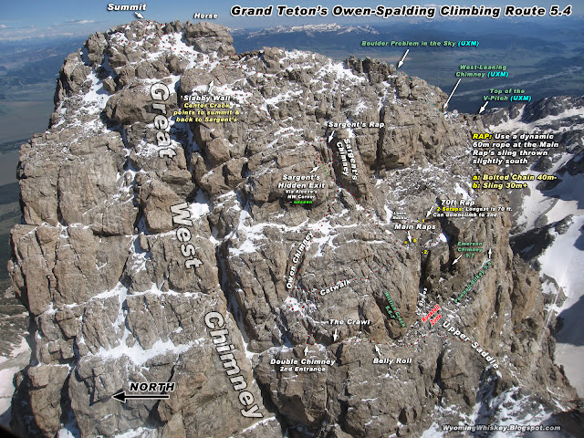


.JPG)
A fat ledge under the main rappel area
This is a good place to check your rope after leaving the Main Rap's sling or bolt. Photographer is at the 2nd setup of the 70' Rap. You can see the ledge in the next image. This is not the ledge 6-10 feet immediately below the raps stations. This is further down.
Click to Download or Enlarge the following images...
.jpg)


Again, turn around and go bag the Enclosure (the western spur off the
Grand
Teton's Upper Saddle) if conditions are really poor on the Grand Teton and you want to bail.
It's a funky scramble and it requires your attention if it's slick.


Original ascent path

Owen-Spalding Climbing Route
Click to enlarge
Overview of the route between the Lower Saddle and Upper Saddle & Exum Ridge
A few trip reports for April through October
July 17th, 2016 (UXM) PNG Variation
~~~~~~~~~~
Overview - Owen-Spalding
The Approach to the Lower Saddle
Wyoming Whiskey Home Page
All of our images may be used without permission or attribution for all not-for-profit purposes
Enjoy Safe Climbing